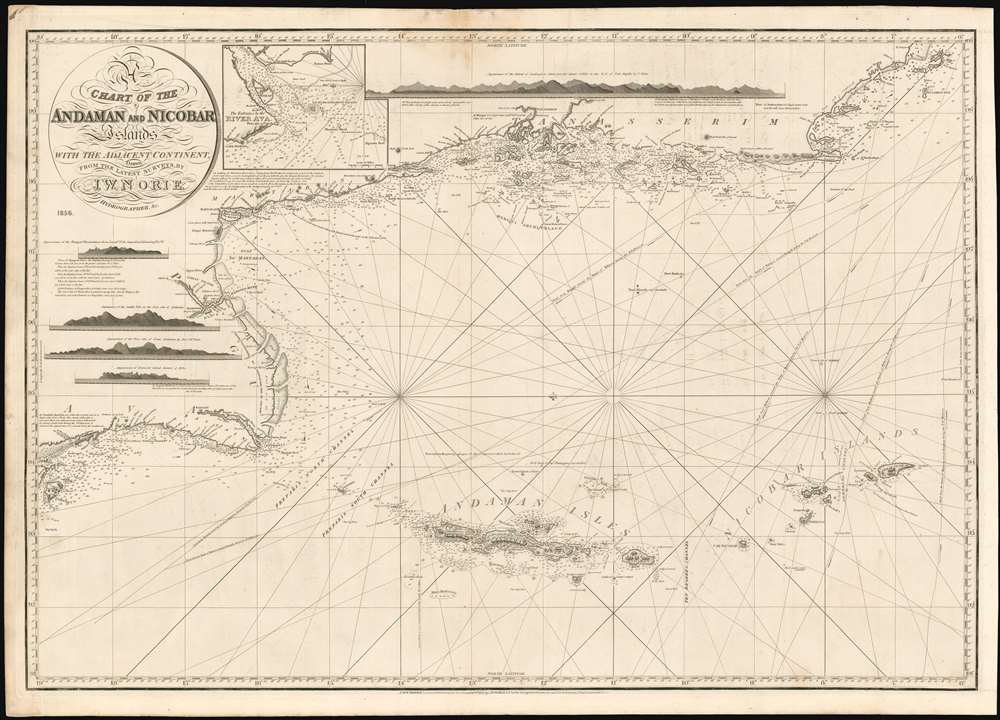
1856 Norie Map of the Andaman Islands, South Burma, and Thailand's West Coast
BurmaThailandAndamanNicobar-norie-1856$1,000.00

Title
A Chart of the Andaman and Nicobar Islands with the Adjacent Continent, Drawn from the latest Surveys, by J. W. Norie, Hydrographer.
1856 (dated) 24.75 x 36 in (62.865 x 91.44 cm) 1 : 1630649
1856 (dated) 24.75 x 36 in (62.865 x 91.44 cm) 1 : 1630649
Description
A scarce 1856 blueback nautical map by J. W. Norie depicting the Andaman Islands and the Nicobar Islands, as well as parts of modern-day Burma (Pegu) and Thailand (Tanasserim).
A Closer Look
Oriented to the east, Norie's map covers from Ramree Island and Sandoway (today a popular resort known as Nagapali Beach, Myanmar), then southeast around Pegu and past Rangoon (Yangon), then along the Myanmar and Thai coastline as far south as Ko Tarutao (Trotto), in modern-day southern Thailand. The map includes the large Thai coastal city of Phuket, then known as Junkseylon Island.Andaman and Nicobar Islands
The foci of this map, as the title suggests, are the Andaman and Nicobar Islands. The Andaman Islands were well known even in antiquity. Although Ptolemy may have mentioned them under a different name, they were definitely referred to by 9th-century Arab geographers. In the 10th century, the Persian navigator Buzurg ibn Shahriyar of Ramhormuz refers to them in his narrative Ajaib al-Hind (The Wonders of India). Shahriyar describes the inhabitants of Great Andaman as fierce cannibals - a reputation they would maintain well into the late 19th century. Marco Polo also refers to the Andamans, where, in one of his more whimsical and memorable passages, he describes the inhabitants as having heads like dogs.The Andamans Become Significant
Although first mapped in some detail in the late 1780s by British naval commanders, the Andaman Islands remained in relative obscurity well into the early 19th century. The British founded several minor colonies on the islands, including the penal colonies of Port Chatham and Port Cornwallis. These initial forays into settling the islands were general failures due to high instances of disease and an exceptionally fierce indigenous population. In 1824, shortly after Norie issued the 1817 first edition of this map, the Andaman Islands attained greater significance. Port Cornwallis, on the northwestern coast of Great Andaman, was chosen as a staging point for British fleets transporting troops to Pegu to fight in the First Burmese War (1824 - 1826). The subsequent Second Anglo-Burmese War (1852 - 1853), which ended with Britain's complete domination of the region, ended just before this map was published. Significant improvements to the charting of the coastline appear along the Burmese coast near Mergui and the coast south of Ramree Island, although it is unclear whether these updates appeared on the new 1833 plate or were added for the 1856 update. Despite the regularly updated charts, the archipelago was hazardous to navigate throughout the early 19th century and was the site of countless shipwrecks. The survivors of these shipwrecks were rarely seen again. Some of these may have been victims of indigenous anthropophagi. However, Ramree Island is notorious for its voracious crocodile population, which was reputed to have played an effective role in preventing the Japanese retreat from the island in February 1945.No Outsiders
While the Andamans are now often sought by tourists and divers, not all of the islands are friendly to outsiders. The denizens of North Sentinel Island (North Centinel, on the chart) are well known for their violent rejection of outsiders, retaining their status as one of the world's few 'uncontacted peoples.'Publication History and Census
Norie produced the first edition of A New Chart of the Andaman and Nicobar Islands in 1817 and updated it at least twice, in 1827 and 1831. This, in turn, was replaced in 1833 with A Chart of the Andaman and Nicobar Islands, an entirely new plate, which was then re-issued by Norie and Wilson in 1856. Norie charts are rare; this example is exceptionally so. While we are aware of three other copies that have reached the market, there are no copies of any edition of this chart listed in OCLC.Cartographer
John William Norie (June 3, 1772 - December 24, 1843) was a British teacher of navigation, hydrographer, chart maker, and publisher of maritime manuals active in London, England in the late 18th and early 19th centuries. Norie was born in Wapping, London, an area long associated with the maritime sciences. Norie's career as a chart maker commenced under the tutelage of William Heather, a prominent purveyor and publisher of nautical charts, pilot books, and navigational tools who took over the firm of Mount and Page in 1765. Heather and Norie were likely acquainted through John Hamilton Moore, another important chart maker with whom both seem to have been associated early in their careers. Heather hired Norie to teach basic navigation at his shop at 157 Leadenhall Street. Under Heather Norie also distinguished himself as a draftsman, completing many of the early charts associated with the Heather firm. When Heather died in 1812 John Norie partnered with George Wilson, a moneyed 'man about town' with little experience in the maritime trades, to acquire the map and chart business at 9500 British Pounds. It proved a good deal for Norie, who retained all copyright privileges and drew 1/4 quarter share of business profits, as well an impressive quarterly salary and, for doing all of the work, 1/3rd of Wilson's share. The firm, referred to as the 'Naval Warehouse' quickly acquired a reputation for quality navigational materials and became a favorite of merchant seamen. It was even referenced in Charles Dickens' classic novel Dombey and Son. In 1819, Norie and Wilson acquired the failing chart business of David Steel, which significantly increased the size, though not quality, of their chart catalogue. With the rise of the British Admiralty and its own maritime chart productions, the business of "Chart Purveyor" in London dramatically changed. Admiralty charts and pilot books, designed for military use, were offered through established intermediaries, like Norie, at bargain prices. Most chart makers of the period found it profitable to use the highly technical Admiralty charts to update their own more decorative vernacular charts. For a brief time this practice proved exceptionally profitable but eventually began to draw criticism. Nonetheless, Norie retired to Edinburgh in 1840 and died a wealthy man in 1843. In 1840 the business passed to a nephew of George Wilson, Charles Wilson, who renamed the firm "Norie & Wilson". William Heather Norie, J. W. Norie's own son, produced few charts, instead pursuing a career in the legal field. Norie & Wilson merged with James Imray's prosperous chart business in 1899, becoming Imray, Laurie, Norie & Wilson, a profitable concern that remains active in the maritime charting industry. More by this mapmaker...
Condition
Very good. Few marginal mends with no loss of image. Stain at upper centerfold.