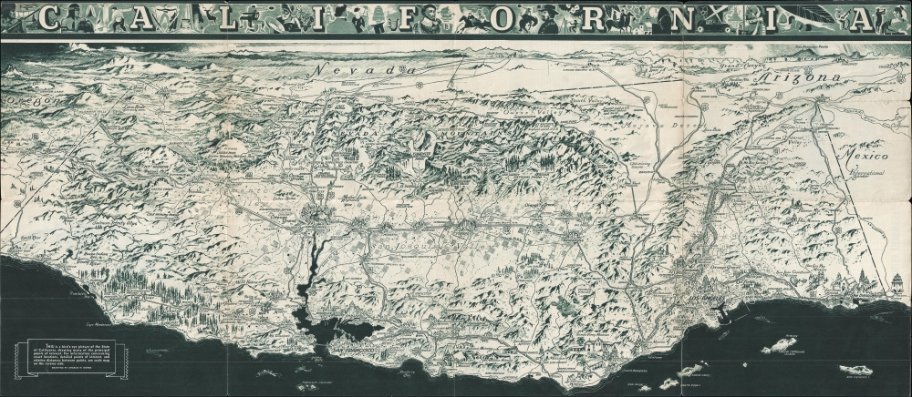
1936 Owens Bird's Eye View of California
California-owens-1936$250.00

Title
California. / California Official Tourist Picture Map.
1936 (dated) 16.5 x 38 in (41.91 x 96.52 cm)
1936 (dated) 16.5 x 38 in (41.91 x 96.52 cm)
Description
This is a c. 1936 Charles Hamilton Owens bird's eye view of California. This map was promoted and distributed by the All-Year-Club to promote California tourism.
A Closer Look
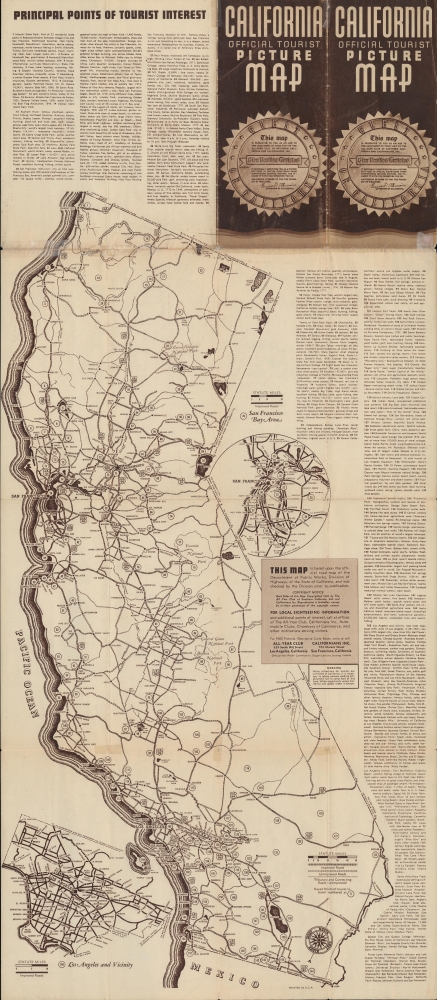
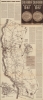
Coverage looks east on California, embracing from Grants Pass, Oregon to Phoenix, Arizona and Tijuana, Mexico and from Salt Lake City, Utah to the Pacific Ocean. Cities and towns throughout are labeled, among them Sacramento, San Francisco, Los Angeles, San Diego, Las Vegas, Yuma, and Flagstaff. The transportation network is highlighted, with major highways and railway lines labeled. The Union Pacific, Southern Pacific, Western Pacific, and Santa Fe Railroads are among the labeled railroads. Several national parks, including Yosemite, Sequoia, and Redwood in California, Crater Lake in Oregon, and the Grand Canyon in Arizona appear as well. Both Mount Whitney (the highest point in the United States at the time) and Death Valley (the lowest point) are labeled. Famous landmarks, such as the Golden Gate Bridge, the Oakland Bay Bridge, the Rose Bowl, and the California State Capital Building are all drawn in profile. Verso content features a more traditional map and highlights points of interest to tourism. There also, is a welcome message from Frank F. Merriam, Governor of California from 1934 - 1939.The All-Year Club of Southern California
By the 1910s, Southern California was already a winter destination, a haven for easterners keen to escape New England winters. By the early 1920s, businessmen realized tourism need not be seasonal; Southern California's 'amazing' weather could draw visitors year-round. In 1921, a group of nineteen Southern California businessmen, led by Harry Chandler (publisher of the Los Angeles Times), created the All-Year Club of Southern California as a spin-off of the Los Angeles Chamber of Commerce. The club lobbied the county Board of Supervisors for funding to sell southern California as a summer resort. The push began in Texas, Arizona, and Oklahoma, where residents would see L.A.'s ninety degrees days with low humidity as relief from the sweltering Midwestern summer. That year, a single large resort reported a daily increase of 100 visitors. Likewise, the Santa Fe, Southern Pacific, and Union Pacific railroads reported record ticket sales during the summer of 1921. These early successes were proof of concept for the All-Year Club, and so it expanded promotion. Numbers continued to rise, as did the Club's budget, and by 1926 the All-Year Club was spending $450,000 on advertising and promotional material. However, not everything was positive. Even though SoCal was booming, ads only wanted tourists, not job-seekers. The ads stated categorically that tourists were welcome, but job-seekers were not, since they would not be able to find work. Nonetheless, the hopeful unemployed came, leading to an ongoing population boom. The All-Year Club of Southern California operated under that name until 1968, when it became the Greater Los Angeles Visitors and Convention Bureau, which later merged with the Southern California Visitors Council. Until 2012, the organization had been known as LA Inc., and today it is the Los Angeles Tourism and Convention Board.Publication History and Census
This map was drawn by Charles Hamilton Owens and published by the All-Year Club of Southern California in 1936.Cartographer
Charles Hamilton Owens (Feb 16, 1881 - March 3, 1958) was an American painter and illustrator and staff illustrator for the Los Angeles Times. Born in San Francisco, he had a passion for drawing from a young age. After landing a job as a messenger for The San Francisco Examiner, Owens began being taught his trade by the newspaper's illustrators. Although it is unclear exactly where Owens started his career as a newspaper staff artist, his reputation was launched by his detailed sketches of the 1906 San Francisco earthquake and fire for a New York paper, using only wire reports and his knowledge of the city. By 1910, Owens was working for the Los Angeles Examiner. Even at this point in his career, Owens was known for experimenting with new forms of illustration, fusing drawings of events with photographs. Owens's map of the Titanic disaster used a high oblique perspective, 'capturing the earth's sphericity and showing the polar regions on a curving horizon.' By the 1920s, Owens reputation as an artist in Los Angeles had grown beyond the realm of journalism. He had a studio and received commissions for landscapes and had exhibited watercolors of California and Hawaii landscapes. Thus, when Owens began creating his war series in April/May 1942, he had all the necessary skills to create visually striking works. The Los Angeles Times began a series of maps for its readers, which were full-page inserts that would appear every Monday and Saturday. Owens's maps would be included in the Monday issues, and a Rand McNally map would be included on Saturdays. The Rand McNally maps, however, were discontinued on June 27, 1942, but Owens's maps continued to be printed. His last war map was published on September 10, 1945, a little over a week after the Japanese surrender. Owens died in Los Angeles on March 3, 1958. More by this mapmaker...
Condition
Good. Wear along original fold lines. Verso repairs to fold separations. Old tape repairs on verso. Highway map of California on verso.