1753 Jefferys Map of Callao (Lima), Peru and Chart of Adjacent Coastline
Callao-jefferys-1753$500.00

Title
The Port of Callao, in the South Sea...
1753 (undated) 9 x 15 in (22.86 x 38.1 cm) 1 : 188000
1753 (undated) 9 x 15 in (22.86 x 38.1 cm) 1 : 188000
Description
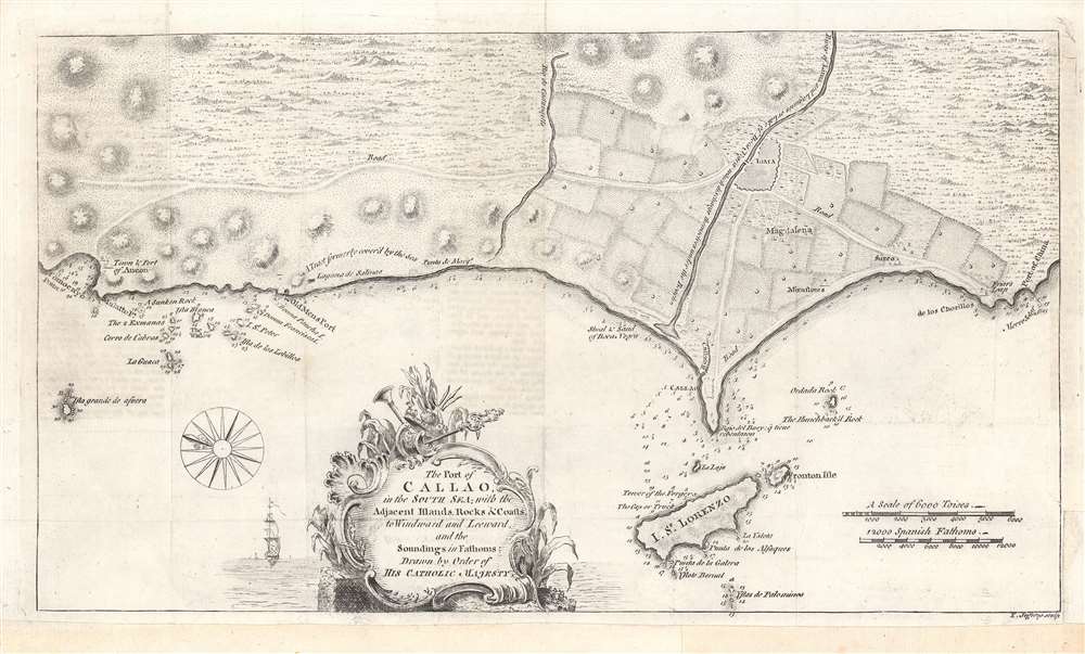
This is a rare work by the British cartographer Thomas Jefferys, a 1753 map of Callao and Lima in Peru. It depicts the coastline of the Lima region while also serving as a nautical chart, noting soundings, islets, and other features.
The motivation for the map's production is not immediately clear, but Jefferys' connections with the Crown and the map's dedication to 'His Catholic Majesty' would suggest it was considered important information for the Court, especially given the regular warfare between Britain and Spain across the 18th century. Although produced during a period of peace, the British and Spanish had recently negotiated an end to the War of Jenkins' Ear (1739 - 1748), which was fought in the Americas but became subsumed under the wider War of Austrian Succession (1740 - 1748). Afterwards, the two empires avoided direct confrontations but generally fell into opposing camps, as during the Seven Years' War (1756 - 1763) and the American Revolutionary War (1775 - 1783).
Callao was founded two years after Lima, about 15 km to the west, and grew into a major port, not just for Lima but for all of Spanish South America. Any goods bound for export coming from the southern half of Spanish South America went through Callao, even if originating east of the Andes in what is now Argentina. Thereafter, they were sent to Panama and carried overland to Caribbean ports or travelled west across the Pacific as part of the Manila Galleon Trade.
In 1746, a powerful earthquake followed by a tsunami completely destroyed Callao and badly damaged Lima. Afterwards, Callao had to be entirely rebuilt, including fortifications at the end of the promontory on which Callao sits, which are faintly visible here. The resulting structure, the Fortaleza del Real Felipe, was built between 1747 and 1774 and was thus under construction when this map was made. The importance of defending Lima and the risk of seaborne pirate attack meant that the project received considerable resources and became one of the most important structures in the Spanish New World colonies. Its value was proven a century later, ironically against the Spanish, when the former imperial master launched a failed attempt to recapture independent Peru in 1866.
A Closer Look
This overhead view of the coast is oriented towards the east, covering an area of about 30 miles, from Ancon in the north to Chorrillos in the south. Waterways, agricultural and urban areas, and elevation are indicated. Scales are given in toises and Spanish fathoms.The motivation for the map's production is not immediately clear, but Jefferys' connections with the Crown and the map's dedication to 'His Catholic Majesty' would suggest it was considered important information for the Court, especially given the regular warfare between Britain and Spain across the 18th century. Although produced during a period of peace, the British and Spanish had recently negotiated an end to the War of Jenkins' Ear (1739 - 1748), which was fought in the Americas but became subsumed under the wider War of Austrian Succession (1740 - 1748). Afterwards, the two empires avoided direct confrontations but generally fell into opposing camps, as during the Seven Years' War (1756 - 1763) and the American Revolutionary War (1775 - 1783).
Lima and Callao
Lima was founded in 1537 as a power base for Francisco Pizarro in his fight against both indigenous forces and Spanish rivals. The city was built somewhat inland to protect from seaborne attack, and Callao developed as the port to Lima. Lima was the capital of the Viceroyalty of Peru from 1543 onwards. The city walls were built between 1684 and 1687, to guard against attack from pirates who roamed the Pacific Ocean.Callao was founded two years after Lima, about 15 km to the west, and grew into a major port, not just for Lima but for all of Spanish South America. Any goods bound for export coming from the southern half of Spanish South America went through Callao, even if originating east of the Andes in what is now Argentina. Thereafter, they were sent to Panama and carried overland to Caribbean ports or travelled west across the Pacific as part of the Manila Galleon Trade.
In 1746, a powerful earthquake followed by a tsunami completely destroyed Callao and badly damaged Lima. Afterwards, Callao had to be entirely rebuilt, including fortifications at the end of the promontory on which Callao sits, which are faintly visible here. The resulting structure, the Fortaleza del Real Felipe, was built between 1747 and 1774 and was thus under construction when this map was made. The importance of defending Lima and the risk of seaborne pirate attack meant that the project received considerable resources and became one of the most important structures in the Spanish New World colonies. Its value was proven a century later, ironically against the Spanish, when the former imperial master launched a failed attempt to recapture independent Peru in 1866.
Publication History and Census
This map was made by Thomas Jefferys, known as the 'Geographer to the Prince of Wales' and later as 'Geographer to the King.' It is undated but appeared in 1753 in the important publication The Gentleman’s Magazine. It is only independently cataloged in the holdings of a small handful of institutions, though is likely to be distributed in institutions holding copies of The Gentleman’s Magazine from 1753.Cartographer
Thomas Jefferys (1695 - November 20, 1771) was one of the most prominent and prolific map publishers and engravers of his day. Jefferys was born in Birmingham and was apprenticed to the engraver Emmanuel Bowen in 1735. Later, in the 1740s he engraved several maps for the popular periodical Gentleman's Magazine. Around 1740 Jefferys was finally able to go into business for himself and in 1746 received an appointment as 'Geographer to Fredrick, Prince of Wales,' which shortly after translated to the position of 'Royal Cartographer to King George III.' Jefferys initially specialized in compiling and re-engraving the works of earlier cartographers into more coherent cartographic wholes. Later, while not salaried position, Jefferys' appointment as 'Royal Cartographer' guaranteed preferential access to the most up to date cartographic material available, allowing him to produce new and updated charts of exceptional accuracy. He his best known for his maps of the Americas, particularly the posthumously published 1775 American Atlas, which included some of the finest and most important late colonial era maps of America ever made. Despite his prolific publishing history, royal appointments, and international publishing fame, Jefferys lived most of his life in dire economic straits. He was bailed out of bankruptcy by Robert Sayer during the production of the American Atlas. In the end, Jefferys died suddenly with very little to his name. Nonetheless, his cartographic legacy survived, and even after his death in 1771, many of his important maps continued to be published and republished by Sayer and Bennet, Conrad Lotter, Georges Louis Le Rouge, Laurie and Whittle, and others. Many attribute some of Jefferys best maps to the colorful and criminally inclined Irish cartographic genius Braddock Mead (John Green, c. 1688 - 1757), who is considered the 'secret behind Jefferys.' Jefferys was succeeded by his son, also Thomas, who had little success as a cartographer and eventually partnered with, then sold his stock and plates to William Faden - Jefferys' true heir. More by this mapmaker...
Condition
Very good. Fold lines visible.
References
OCLC 45130851.