2002 U. S. Geological Survey Photomosaic Map of Callisto, Moon of Jupiter
CallistoPhotomosaic-usgs-2002$150.00

Title
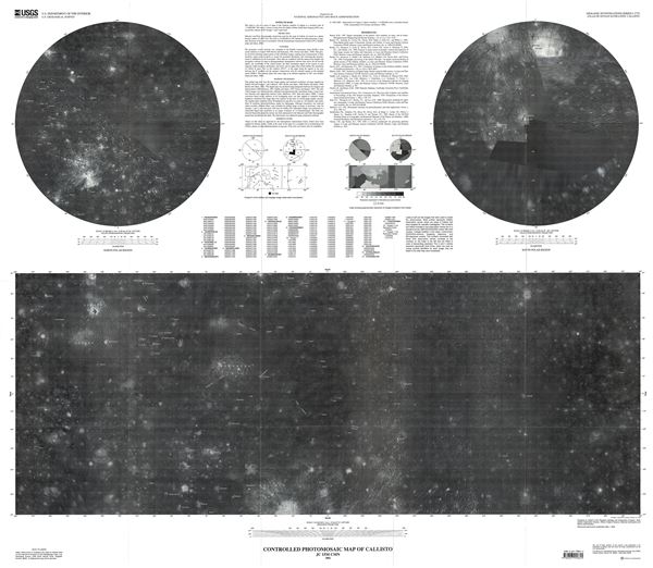
Controlled Photomosaic Map of Callisto.
2002 (dated) 37 x 42 in (93.98 x 106.68 cm) 1 : 15000000
2002 (dated) 37 x 42 in (93.98 x 106.68 cm) 1 : 15000000
Description
This is a beautiful 2002 example of the U. S. Geological Survey map or photomosaic of Callisto, the moon of the planet Jupiter. This map of the third largest moon in our Solar System was compiled from images from the Voyager 1 and 2 space crafts. The map identifies Valhalla, the Solar System's largest multi-ring crater basin. The Asgard formation, the second largest multi-ring structure, is also shown in this map. The North Polar Region and the South Polar Region are represented in two insets in the upper left and right quadrants respectively.
The primary mission of the Voyager 1 and 2 at the time of launch was to explore Jupiter and Saturn. Since then, the mission objective has been extended to exploring the Solar System beyond the outer planets, as far as the Sun's sphere of influence and possibly even beyond the outer limits of our Solar System. Voyager 2, launched in August 1977, flew by Jupiter and Saturn and continued on to explore Uranus and Neptune, becoming the only spacecraft to visit these outer planets. It is also the only spacecraft to have studied all four giant planets of our Solar System at close range. Voyager 1, launched in September 1977, also flew by Jupiter and Saturn and continued on toward interstellar space. Both space crafts are carrying a golden record explaining their origins and containing sounds and images portraying Earths life and its culture in all its diversity. Although departing the Solar System in different directions, both Voyagers have reached the Heliosheath, where the solar wind mixes with interstellar wind.
This map was prepared for the National Aeronautics and Space Administration and published by the U.S. Geological Survey as Geological Investigations Series Atlas of Jovian Satellites map I-2770.
Cartographer
The Office of the Coast Survey (later the U.S. Geodetic Survey) (1807 - present), founded in 1807 by President Thomas Jefferson and Secretary of Commerce Albert Gallatin, is the oldest scientific organization in the U.S. Federal Government. Jefferson created the "Survey of the Coast," as it was then called, in response to a need for accurate navigational charts of the new nation's coasts and harbors. The first superintendent of the Coast Survey was Swiss immigrant and West Point mathematics professor Ferdinand Hassler. Under the direction of Hassler, from 1816 to 1843, the ideological and scientific foundations for the Coast Survey were established. Hassler, and the Coast Survey under him developed a reputation for uncompromising dedication to the principles of accuracy and excellence. Hassler lead the Coast Survey until his death in 1843, at which time Alexander Dallas Bache, a great-grandson of Benjamin Franklin, took the helm. Under the leadership A. D. Bache, the Coast Survey did most of its most important work. During his Superintendence, from 1843 to 1865, Bache was steadfast advocate of American science and navigation and in fact founded the American Academy of Sciences. Bache was succeeded by Benjamin Pierce who ran the Survey from 1867 to 1874. Pierce was in turn succeeded by Carlile Pollock Patterson who was Superintendent from 1874 to 1881. In 1878, under Patterson's superintendence, the U.S. Coast Survey was reorganized as the U.S. Coast and Geodetic Survey (C & GS or USGS) to accommodate topographic as well as nautical surveys. Today the Coast Survey is part of the National Oceanic and Atmospheric Administration or NOAA. More by this mapmaker...
Source
Geologic Investigations Series. U.S. Department of the Interior. U.S. Geological Survey.
Condition
Very good. Original fold lines visible. Blank on verso.