This item has been sold, but you can get on the Waitlist to be notified if another example becomes available, or purchase a digital scan.
1948 O'Toole Pictorial Map of Cape Ann, Massachusetts
CapeAnn-otoole-1948$225.00

Title
Cape Ann Gloucester, Magnolia, Rockport, Pigeon Cove, Lanesville, Bay View, Annisquam.
1948 (undated) 12 x 15.5 in (30.48 x 39.37 cm) 1 : 60480
1948 (undated) 12 x 15.5 in (30.48 x 39.37 cm) 1 : 60480
Description
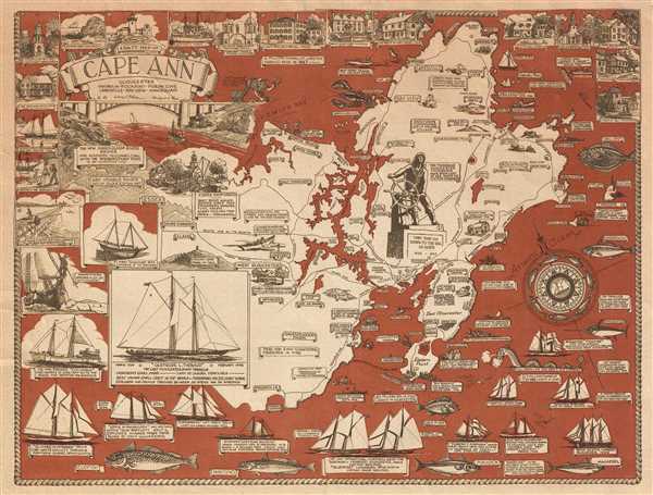
A scarce and unusual map, this is a 1948 Larry O'Toole pictorial map of Cape Ann, Massachusetts. Cape Ann is in northeastern Massachusetts, about 30 miles from Boston. Cape Ann marks the northern limit of Massachusetts Bay. A richly illustrated map, A Salty Map of Cape Ann is almost interactive and is full of both historical and practical information about the area. Most of the practical information seems to be aimed at weekend visitors, making claims that 'the best sport fishing on the east coast' is off Cape Ann, or that there is good fishing for 'landlubbers' on Dog Bar Breakwater. Contemporary facts about the area are also given, such as '6 million pounds of lobster handled here in 1947'.
The map is framed by historical sites and sailing ships. The sites are numbered and marked on the map, while most of the ships that are depicted were either lost at sea or made a fantastic voyage. The 'Florence C. Robinson' for example, sailed from Rocky Neck on November 21, 1938 and went to the Galapagos Islands and Tahiti. The two largest images on the map are of the 'Gertrude L. Thebaud', which was the last Gloucester dory trawler, and is the 'best known small craft in the world' according to the map, and a sketch of the new Annisquam River bridge, which was to be completed in 1950.
The map was drawn and copyrighted by Larry O'Toole of Rockport, Massachusetts. There were at least two editions. A large format edition with blue oceans published in 1947, and the present smaller format edition, with read oceans, published in 1948.
Cartographer
Larry O'Toole (1909 – April 10, 1951) was a Rockport, Massachusetts based adventurer, visual artist, and muralist. For a time, he was the official artist of the U.S. Coast Guard. He also painted several murals, known for their 'salty humor,' for American naval bases. At least one is in the Boston Navy Officer's Club. From 1938 – 1939, O'Toole, also an accomplished sailor, manned movie star Sterling Hayden's square-rigged brigantine, the 'Florence Robinson,' on a voyage to Tahiti. O'Toole made few maps, but his Salty Map of Cape Ann is a notably fine example of mid-20th century pictorial mapmaking. More by this mapmaker...
Condition
Very good. Blank on verso.
References
OCLC 5702066. University of Southern Maine, Osher Map Library, MO-1949-75.