1726 Valentijn Map of the Cape of Good Hope, South Africa
CapeofGoodHope-valentijn-1726$950.00

Title
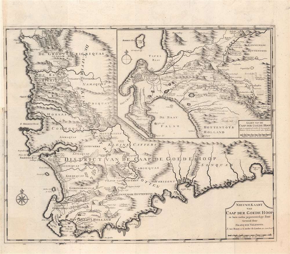
Nieuwe Kaart van Caap der Goede Hoop in hare rechte jegenwoordige staaat vertoond door Francois Valentyn.
1726 (undated) 20.5 x 24.5 in (52.07 x 62.23 cm) 1 : 275000
1726 (undated) 20.5 x 24.5 in (52.07 x 62.23 cm) 1 : 275000
Description
A beautiful and remarkable 1726 Francois Valentijn map of the Cape of Good Hope, South Africa. This piece comprises two important maps printed on a single sheet. The primary map details the Cape of Good Hope from the Doornbosch River to the Baay van Algoa (Algoa Bay). The second map, appearing in the upper right quadrant, offers a more detailed depiction of the modern day Cape Town region from Robben Island to False Bay and east as far as Draakenstein. Both maps offer exceptional inland detail with landholders noted throughout - an exceptionally valuable resource for anyone studying the early development of the Cape. Being one of the earliest sophisticated maps of the region, Valentijn's chart was used as a model by numerous subsequent cartographers.
Publication History and Census
This map was issued in Amsterdam in Francois Valentijn's 1726 Oud en nieuw Oost-Indien. It was published by Joannes van Braam and Gerard onder de Linden, whose names appear on the imprint. Today this important map is very scarce as we note only two examples cataloged in OCLC which are part of the collections at the Library of Congress and the University of Texas at Arlington.Cartographer
Francois Valentijn (April 17, 1666 - August 6, 1727) was a Dutch minister, naturalist, colonial administrator, and historian active in Holland and the East Indies, in the late 17th and early 18th centuries. Valentijn was born in Dordrecht, Holland and studied at the Universities and Leiden and Utrecht before, in 1685, taking a position with the Dutch East India Company (VOC). He remained in the East Indies for about 10 years before returning to Dordrecht. Unable to adjust to life in Europe, he returned to the East Indies in 1705 where he remained for another 9 years. After 19 total years in the Orient working for the VOC, Valentijn once again returned to Holland where he composed his eight volume five part masterwork Oud en Nieuw Oost-Indien. The scope and detail of this work, including over 1000 engraved images and numerous maps was unprecedented with regards to Asia. The work contained some of the finest and most detailed large scale maps of the East Indies ever published. The most important of these focus on Taiwan and Malaya. Valentijn most likely drew on secret VOC manuscript maps and documents, a fact that makes it exceptionally surprising that his works were actually published. Valentijn academic scholarship, in sharp contrast to his cartographic work, is often highly criticized as being self-aggrandizing and, more often than not, plagiarized. More by this mapmaker...
Source
Valentijn, F., Oud en Nieuw Oost-Indien,( Dordrecht: J. van Braam) 1726.
Condition
Very good. Crisp dark impression suggestive of an early strike off the plate. Original platemark visible. Left margin expertly extended where originally joined to volume. Blank on verso.
References
Library of Congress, Map Division, G8503.C3 1726 .V3. OCLC: 871359935. Norwich, O. I., Norwich's Maps of Africa: An Illustrated and Annotated Cartobibliography, no 214.