Digital Image: 1875 Livingstone Map of Central Africa
CentralAfricaLivingstone-harper-1875_d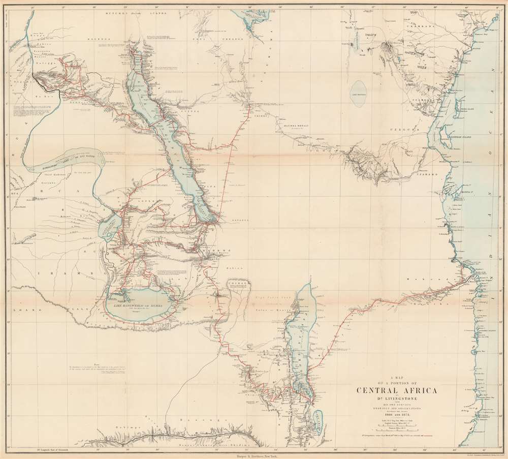

Title
A Map of a Portion of Central Africa by Dr. Livingstone from His Own Surveys Drawings and Observations Between the Years 1866 and 1873.
1875 (undated) 29.5 x 32.75 in (74.93 x 83.185 cm) 1 : 2173248
1875 (undated) 29.5 x 32.75 in (74.93 x 83.185 cm) 1 : 2173248
Description
FOR THE ORIGINAL ANTIQUE MAP, WITH HISTORICAL ANALYSIS, CLICK HERE.
Digital Map Information
Geographicus maintains an archive of high-resolution rare map scans. We scan our maps at 300 DPI or higher, with newer images being 600 DPI, (either TIFF or JPEG, depending on when the scan was done) which is most cases in suitable for enlargement and printing.
Delivery
Once you purchase our digital scan service, you will receive a download link via email - usually within seconds. Digital orders are delivered as ZIP files, an industry standard file compression protocol that any computer should be able to unpack. Some of our files are very large, and can take some time to download. Most files are saved into your computer's 'Downloads' folder. All delivery is electronic. No physical product is shipped.
Credit and Scope of Use
You can use your digial image any way you want! Our digital images are unrestricted by copyright and can be used, modified, and published freely. The textual description that accompanies the original antique map is not included in the sale of digital images and remains protected by copyright. That said, we put significant care and effort into scanning and editing these maps, and we’d appreciate a credit when possible. Should you wish to credit us, please use the following credit line:
Courtesy of Geographicus Rare Antique Maps (https://www.geographicus.com).
How Large Can I Print?
In general, at 300 DPI, you should at least be able to double the size of the actual image, more so with our 600 DPI images. So, if the original was 10 x 12 inches, you can print at 20 x 24 inches, without quality loss. If your display requirements can accommodate some loss in image quality, you can make it even larger. That being said, no quality of scan will allow you to blow up at 10 x 12 inch map to wall size without significant quality loss. For more information, it is best consult a printer or reprographics specialist.
Refunds
If the high resolution image you ordered is unavailable, we will fully refund your purchase. Otherwise, digital images scans are a service, not a tangible product, and cannot be returned or refunded once the download link is used.
Cartographer
Dr. David Livingstone (March 19, 1813 - May 1, 1873) was a Scottish physician, an explorer of Africa, a pioneer Christian missionary with the London Missionary Society, and one of the most beloved British heroes of the late 19th century. Livingstone is renowned worldwide and has been written about extensively, so we will only provide a short summary of his achievements here. Livingstone first arrived in Africa in the arly 1840s and served in numerous posts as a missionary for the London Missionary Society. In his gradual move northward from South Africa, Livingstone found himself in the village of Liyanti on the banks of the Zambezi River in 1851. Livingstone spent the next two years exploring the Zambezi, eventually becoming the first European to see the Mosi-o-Tunya waterfall, now known as Victoria Falls in the West, which Livingstone named for Queen Victoria. He then returned to Britain, where he resigned from the London Missionary Society in 1857 to pursue scientific exploration and opening Central Africa to commerce, mostly in an effort to end the African slave trade. Livingstone left that same year to lead the Second Zambesi Expeditionl which turned into a nightmare because of his poor leadership skills. Nonetheless, this expedition was the first to reach Lake Malawi, but was unable to achieve the stated goals of the expedition of opening the African interior to trade because the Zambezi and Ruvuma Rivers proved impossible to navigate with large vessels. He was ordered by the British government to return home in 1864 due to rising costs and failure to achieve the stated goals of the expedition. Livingstone returned to Africa in 1866 with the stated goal fo finding the source of the Nile. He would spend the rest of his life on this mission and never find success. During these years Livingstone was almost constantly sick adn suffering. He died on May 1, 1873 in Chief Chitambo's village at Ilala, southeast of Lanke Bangweulu in present-day Zambia, of malaria and internal bleeding due to dysentery. Livingstone's explorations in central Africa were truly groundbreaking. He was the first to identify Lake Ngami, Lake Malawi, and Lake Bangweulu to Western science, along with Victoria Falls. He also provided previously unknown details of Lake Tanganyika, Lake Mweru, and numerous river, the most important of which was the upper Zambezi. His explorations filled in many portions of the map that had previously been left blank. More by this mapmaker...