This item has been sold, but you can get on the Waitlist to be notified if another example becomes available, or purchase a digital scan.
1908 British War Office Map of Central America
CentralAmerica-topographicalsection-1908$475.00

Title
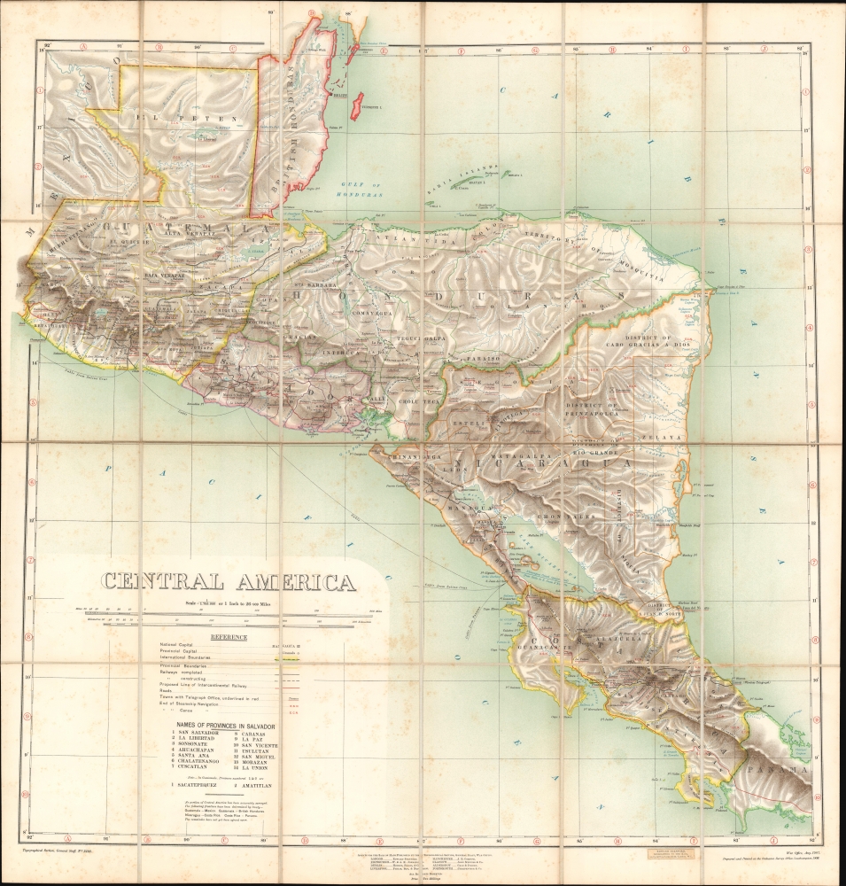
Central America.
1908 (dated) 29.25 x 28 in (74.295 x 71.12 cm) 1 : 1705000
1908 (dated) 29.25 x 28 in (74.295 x 71.12 cm) 1 : 1705000
Description
A fascinating chromolithograph map of Central America issued jointly by the British War Office Topographical Section and the British Ordnance. The map emerged during the peak of global conversation about an interoceanic canal or railroad route to connect the Caribbean Sea, and thus the Atlantic, with the Pacific.
A Closer Look
Coverage embraces Central America from Guatemala and British Honduras to western Panama, encompassing Guatemala, British Honduras (Belize), El Salvador, Honduras, Nicaragua, and Costa Rica. Topography is meticulously rendered with shading. The map is particularly impressive for its delineation of the region's complex inland river systems, as well as annotations throughout designating 'E.S.N' or 'E.C.N', meaning 'End Steam Navigation' or 'End Canoe Navigation' respectively. The map also identifies roads, extent and planned railroads, telegraph offices, and the 'Proposed Line of [an] Intercontinental Railway. The general lines of submarine telegraph cables in the Pacific are also noted.The Interoceanic Route
Central America was of great interest in the early 20th century, when the need for a practical interoceanic connection dominated the global conversation. When this map was issued, there was only one railroad route connecting the Caribbean to the Pacific - the Puerto Barrios-Istapa railroad through Guatemala. Alternate routes are noted on this map, all of which were then in the planning or construction phase, including a railroad passage through Honduras, a proposed canal through Nicaragua, a nearly complete railroad route through Costa Rica, and of course, the Panama Canal Route (not on map). The meticulous notes on river navigation, even by canoe, appearing throughout, underscore the extent to which this area was then being meticulously mapped as well as the rigors inherent in exploring the mountainous jungles.Chromolithography
Chromolithography is a color lithographic technique developed in the mid-19th century. The process involved using multiple lithographic stones, one for each color, to yield a rich composite effect. Oftentimes, the process would start with a black basecoat upon which subsequent colors were layered. Some chromolithographs used 30 or more separate lithographic stones to achieve the desired effect. Chromolithograph color could also be effectively blended for even more dramatic results. The process became extremely popular in the late 19th and early 20th centuries, when it emerged as the dominate method of color printing. The vivid color chromolithography produced made it exceptionally effective for advertising and propaganda imagery.Publication History and Census
This map was first published by the British War Office (Topographical Section, General Staff) in 1907. The present example was updated and issued a year later in 1908 by the Ordnance Survey Office, London. It bears a store paste-down stamp from the Stanford Geographical Establishment in London, an authorized reseller. The map is rare. The OCLC notes just 5 examples located in institutions: The British Library, The Buffalo and Erie County Public Library, McGill University, UC Berkeley, and the University of Cambridge.CartographerS
The British War Office (1857 - 1964) was a department of the British Government responsible for the administration of the Royal Army until 1964, when its functions were transferred to the Ministry of Defense. The War Office was to the Royal Army what the Admiralty was to the Royal Navy, and later, the Air Ministry. Within the War Office, the General Staff Topographical Section was responsible for thousands of maps issued for British intelligence and military use. The Topographical Section was renamed Geographical Section in April 1907. Many, once their military use passed, were offered through licensed agents to the general public. The sole London agent for War Office material was Edward Stanford. More by this mapmaker...
The British Ordnance Survey (1791 - present) is the national mapping agency of Great Britain and is one of the largest producers of maps in the world. This non-ministerial department of the government of the United Kingdom is responsible for producing maps of Great Britain and many of its overseas possessions. The history of the Ordnance Survey goes back as far as 1747, following the Jacobite rising, when King George II commissioned a comprehensive military survey of Scotland to assist further campaigns. The result, produced by Paul Sandby, John Mason and William Roy, was the Duke of Cumberland's Map, the first military quality map of the British Isles. This grew into the Principal Triangulation of Great Britain (1783-1853) under William Roy, and eventually lead to the creation of the Ordnance Survey in 1791. Today the Ordnance Survey produces a large variety of paper maps and digital mapping products. Its large scale maps, issued to the scale of 1:10000, available in sheet map form until the 1980s, are now only available digitally. All maps produced by the Ordnance Survey are in copyright for 50 years after publication. Learn More...
Condition
Very good. Slight foxing. Folds into original binder.
References
OCLC 21821111.