1751 Vaugondy Map of Swabia, Germany
CercleSouabe-vaugondy-1751$175.00

Title
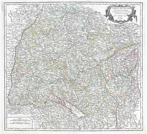
Cercle de Souabe, dans lequel sont distingués les principaux Etats, et les Enclaves de la Maison d'Autriche.
1751 (dated) 20 x 22 in (50.8 x 55.88 cm) 1 : 480000
1751 (dated) 20 x 22 in (50.8 x 55.88 cm) 1 : 480000
Description
This is an attractive 1749 map of Swabia, Germany by Gilles Robert de Vaugondy. The map covers the southwestern parts of Germany along with parts of Switzerland. The map extends from Zurich in Switzerland north to Speyer in Germany and east as far as Donauworth. The entire region is depicted in extraordinary detail, offering both topographical and political information, with forests and mountains beautifully rendered in profile.
The 'circles' of Germany are the 'imperial circles,' administrative units created for tax and defense purposes by the Holy Roman Empire, of which these areas were a part. Prior the French Revolutionary Wars and the Congress of Vienna, the Holy Roman Empire's Circle of Swabia was bordered by Franconia, Bavaria, Palatinate, France and Switzerland. Since the Reformation, the region had been one of the most divided in Europe, with secular princes and Free Cities becoming Protestant, and the ecclesiastical territories (including the Bishoprics of Augsburg, Konstanz and others) remaining Catholic, as did the territories belonging to the Habsburgs, Hohenzollerns and the Margrave of Baden-Baden. The Napoleonic Wars dissolved the Holy Roman Empire in 1806, leading to Germany's eventual consolidation in 1871. With a reputation for being extremely serious and hardworking, Swabia has produced many famous native sons-- Einstein, Brecht, Hegel, Kepler, and of course, Roland Emmerich.
This map was published in the 1751 edition of Vaugondy's Atlas Universel.
Cartographer
Robert de Vaugondy (fl. c. 1716 - 1786) was French may publishing from run by brothers Gilles (1688 - 1766) and Didier (c. 1723 - 1786) Robert de Vaugondy. They were map publishers, engravers, and cartographers active in Paris during the mid-18th century. The father and son team were the inheritors to the important Nicolas Sanson (1600 - 1667) cartographic firm whose stock supplied much of their initial material. Graduating from Sanson's maps, Gilles, and more particularly Didier, began to produce their own substantial corpus. The Vaugondys were well-respected for the detail and accuracy of their maps, for which they capitalized on the resources of 18th-century Paris to compile the most accurate and fantasy-free maps possible. The Vaugondys compiled each map based on their own geographic knowledge, scholarly research, journals of contemporary explorers and missionaries, and direct astronomical observation. Moreover, unlike many cartographers of this period, they took pains to reference their sources. Nevertheless, even in 18th-century Paris, geographical knowledge was limited - especially regarding those unexplored portions of the world, including the poles, the Pacific Northwest of America, and the interiors of Africa, Australia, and South America. In these areas, the Vaugondys, like their rivals De L'Isle and Buache, must be considered speculative or positivist geographers. Speculative geography was a genre of mapmaking that evolved in Europe, particularly Paris, in the middle to late 18th century. Cartographers in this genre would fill in unknown lands with theories based on their knowledge of cartography, personal geographical theories, and often dubious primary source material gathered by explorers. This approach, which attempted to use the known to validate the unknown, naturally engendered rivalries. Vaugondy's feuds with other cartographers, most specifically Phillipe Buache, resulted in numerous conflicting papers presented before the Academie des Sciences, of which both were members. The era of speculative cartography effectively ended with the late 18th-century explorations of Captain Cook, Jean Francois de Galaup de La Perouse, and George Vancouver. After Didier died, his maps were acquired by Jean-Baptiste Fortin, who in 1787 sold them to Charles-François Delamarche (1740 - 1817). While Delamarche prospered from the Vaugondy maps, he defrauded Vaugondy's window Marie Louise Rosalie Dangy of her rightful inheritance and may even have killed her. More by this mapmaker...
Source
Robert de Vaugondy, G., Atlas Universel, (Paris: Antoine Boudet) 1757.
The Atlas Universel was the crowning glory of the Robert de Vaugondy firm's atlas production. The atlas was revolutionary on many levels and exemplified the Vaugondy credo commode, complet, univorme, et suive (convenient, complete, uniform, and easy to use). The atlas thus consisted of a wide corpus of maps, both modern and historical, was of moderate height and width, and featured maps of uniform style and structure. They partnered with Antoine Boudet, a shrewd businessman and publisher with whom they had worked previously, to produce the 1752 first edition. To minimize his fiscal risk, Boudet sold the atlas first by subscription using a large prospectus, receiving in the process over 1100 pre-orders. The first edition appeared in 1752 and contained beautifully produced maps with elaborate freshly designed allegorical cartouche work, generally by Pierre-Edme Babel, Pierre Philippe Choffard, and Charles Nicholas Cochin. Most of the maps were engraved by the Delahaye firm, the payment for whose services ultimately led to legal disputes. Despite proving a popular work of astounding quality, the Atlas Universal received harsh criticism from fellow cartographers, particularly Philipppe Buache. Ever at odds with the Vaugondys, Buache's critical perspective may have been influenced more by political maneuvering than academic affront. The atlas was issued in multiple editions between 1752 and 1788. Later editions, issued after 1786, were taken over by Charles Delamarche, who inherited the Robert de Vaugondy firm and assumed Boudet's publication rights.
Condition
Very good. Split repaired along original centerfold.
References
OCLC 605098241.