Digital Image: 1595 Mercator Map of the Isle of Wight, Anglesey, Guernsey and Jersey Islands
ChannelIslands-mercator-1595_d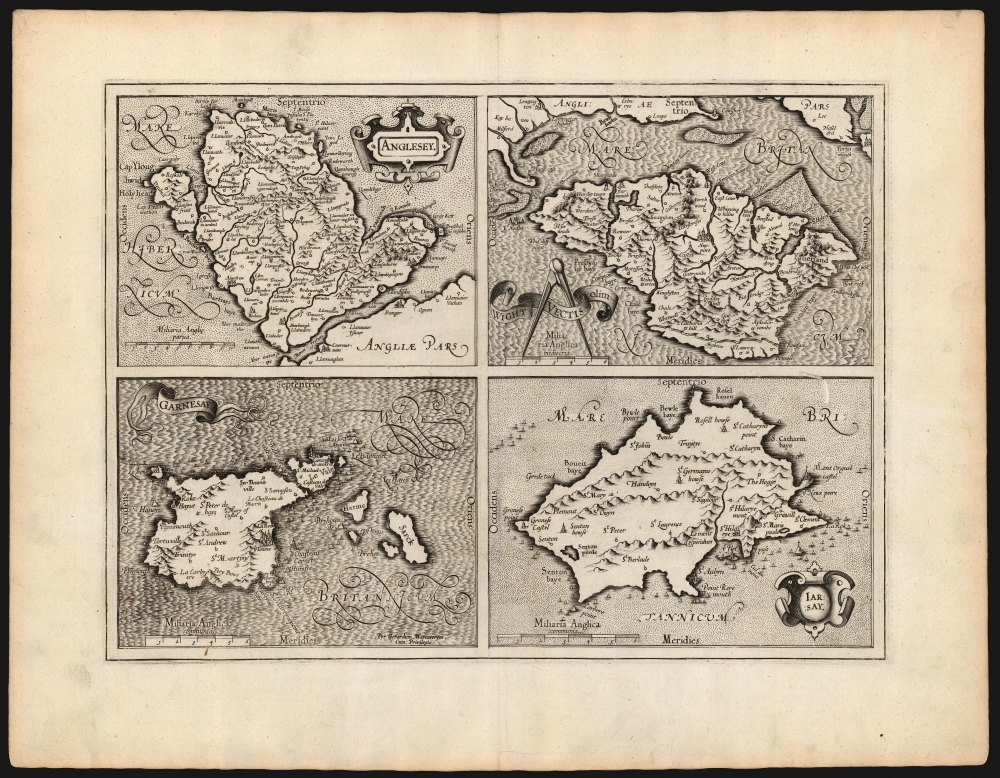

Title
Anglesey/ Wight Vectis olim/ Garnesay/ Jarsey.
1595 (undated) 12.5 x 17 in (31.75 x 43.18 cm)
1595 (undated) 12.5 x 17 in (31.75 x 43.18 cm)
Description
FOR THE ORIGINAL ANTIQUE MAP, WITH HISTORICAL ANALYSIS, CLICK HERE.
Digital Map Information
Geographicus maintains an archive of high-resolution rare map scans. We scan our maps at 300 DPI or higher, with newer images being 600 DPI, (either TIFF or JPEG, depending on when the scan was done) which is most cases in suitable for enlargement and printing.
Delivery
Once you purchase our digital scan service, you will receive a download link via email - usually within seconds. Digital orders are delivered as ZIP files, an industry standard file compression protocol that any computer should be able to unpack. Some of our files are very large, and can take some time to download. Most files are saved into your computer's 'Downloads' folder. All delivery is electronic. No physical product is shipped.
Credit and Scope of Use
You can use your digial image any way you want! Our digital images are unrestricted by copyright and can be used, modified, and published freely. The textual description that accompanies the original antique map is not included in the sale of digital images and remains protected by copyright. That said, we put significant care and effort into scanning and editing these maps, and we’d appreciate a credit when possible. Should you wish to credit us, please use the following credit line:
Courtesy of Geographicus Rare Antique Maps (https://www.geographicus.com).
How Large Can I Print?
In general, at 300 DPI, you should at least be able to double the size of the actual image, more so with our 600 DPI images. So, if the original was 10 x 12 inches, you can print at 20 x 24 inches, without quality loss. If your display requirements can accommodate some loss in image quality, you can make it even larger. That being said, no quality of scan will allow you to blow up at 10 x 12 inch map to wall size without significant quality loss. For more information, it is best consult a printer or reprographics specialist.
Refunds
If the high resolution image you ordered is unavailable, we will fully refund your purchase. Otherwise, digital images scans are a service, not a tangible product, and cannot be returned or refunded once the download link is used.
Cartographer S
Gerard Mercator (March 5, 1512 - December 2, 1594) is a seminal figure in the history of cartography. Mercator was born near Antwerp as Gerard de Cremere in Rupelmonde. He studied Latin, mathematics, and religion in Rupelmonde before his Uncle, Gisbert, a priest, arranged for him to be sent to Hertogenbosch to study under the Brothers of the Common Life. There he was taught by the celebrated Dutch humanist Georgius Macropedius (Joris van Lanckvelt; April 1487 - July 1558). It was there that he changed him name, adapting the Latin term for 'Merchant', that is 'Mercator'. He went on to study at the University of Louvain. After some time, he left Louvain to travel extensively, but returned in 1534 to study mathematics under Gemma Frisius (1508 - 1555). He produced his first world map in 1538 - notable as being the first to represent North America stretching from the Arctic to the southern polar regions. This impressive work earned him the patronage of the Emperor Charles V, for whom along with Van der Heyden and Gemma Frisius, he constructed a terrestrial globe. He then produced an important 1541 globe - the first to offer rhumb lines. Despite growing fame and imperial patronage, Mercator was accused of heresy and in 1552. His accusations were partially due to his Protestant faith, and partly due to his travels, which aroused suspicion. After being released from prison with the support of the University of Louvain, he resumed his cartographic work. It was during this period that he became a close fried to English polymath John Dee (1527 - 1609), who arrived in Louvain in 1548, and with whom Mercator maintained a lifelong correspondence. In 1552, Mercator set himself up as a cartographer in Duisburg and began work on his revised edition of Ptolemy's Geographia. He also taught mathematics in Duisburg from 1559 to 1562. In 1564, he became the Court Cosmographer to Duke Wilhelm of Cleve. During this period, he began to perfect the novel projection for which he is best remembered. The 'Mercator Projection' was first used in 1569 for a massive world map on 18 sheets. On May 5, 1590 Mercator had a stroke which left him paralyzed on his left side. He slowly recovered but suffered frustration at his inability to continue making maps. By 1592, he recovered enough that he was able to work again but by that time he was losing his vision. He had a second stroke near the end of 1593, after which he briefly lost speech. He recovered some power of speech before a third stroke marked his end. Following Mercator's death his descendants, particularly his youngest son Rumold (1541 - December 31, 1599) completed many of his maps and in 1595, published his Atlas. Nonetheless, lacking their father's drive and genius, the firm but languished under heavy competition from Abraham Ortelius. It was not until Mercator's plates were purchased and republished (Mercator / Hondius) by Henricus Hondius II (1597 - 1651) and Jan Jansson (1588 - 1664) that his position as the preeminent cartographer of the age was re-established. More by this mapmaker...
Reyner Wolfe (died 1573) was a Dutch-born English Protestant printer, cartographer, and historian. He was born in Druten; virtually nothing is known of his youth and education. A Protestant, he settled in England prior to 1530, where he would set up as a bookseller in London; his work began to appear in 1542, and was noted for its introducton of Greek and Hebrew typefaces. He was one of the original members of the Stationers' Company, of which society he was made Master in 1559, 1564, 1567 and 1572. He planned and began a Universal Cosmography, but he died before it was finished. Much of the work would be included in Holinshed's Chronicles of 1577. Wolfe is known to have produced at least one map in manuscript, a c. 1560 map of the Channel Island, Guernsey: it is not recorded that any of his cartographic works were printed by him, or what others survived. But certainly his Guernsey map would find its way to Gerard Mercator, who would reproduce it in his 1595 Atlas. Learn More...
Christopher Saxton (c. 1540 – c. 1610) was an English cartographer. He produced the first county maps of England and Wales. His childhood and education is not well understood but he may have attended the predecessor school to Queen Elizabeth Grammar School, Wakefield and also Cambridge University. It is supposed that he learned mapmaking from John Rudd, the vicar of Dewsbury and Thornhill. He was commissioned to begin a survey of England, financed by Thomas Seckford of Suffolk, Saxton began the work in 1574; in 1577 he extended his survey to Wales. The first plates were engraved in 1574, and they were complete in 1578. The maps were produced in the Atlas of the Counties of England and Wales published in 1579. The atlas was popular and influential; cartographers including John Speed would add to and adapt Saxton's work. Saxton may have engraved the maps of the Welsh counties himself: the remainder of the atlas was engraved by Dutch and Flemish artists. Learn More...
Giovanni Battista Boazio (fl. 1588 – 1606) was an Italian draftsman and cartographer. A large part of his career was spent working in England, where he would produce maps of Ireland, the Isle of Wight, and an array of maps recording Sir Francis Drake's voyages to the West Indies. His map of Ireland would appear in Ortelius' Theatrum, while his Isle of Wight would provide Mercator with the source for his map of the island. Learn More...
Source
Mercator, G., Atlas sive Cosmographicae, (Duisberg: Busius) 1595.
Mercator's Atlas is one of the most important works in the history of cartography. Although in fact Ortelius was the first to publish a proper atlas, the Teatrum Orbis Terrarum, Mercator's work the first book to employ the term Atlas for a collection of maps. The term is derived both from the mythical titan, Atlas, who was forced to bear the world upon his shoulders, and the Libyan king, philosopher, and astronomer of the same name that, so the legend goes, constructed the first globe. Mercator dedicated the final 25 years of his life to compile the Atlas. He published two parts during his lifetime in 1585 and 1589, but the final part published posthumously by his son Rumold Mercator, in 1595. The map plates for the Atlas were later acquired by Jodocus Hondius who published the most complete and well known edition in 1606. It was Jodocus who popularized the Atlas and who did the most to elevate Gerard Mercator's name.
References
OCLC 843398126. Rumsey 10501.115 (1607) Van der Krogt, P. C. J., Koeman's Atlantes Neerlandici, (Vol. 1), 5700:1A. Karrow, R. W., Mapmakers of the Sixteenth Century and their Maps 56/159.