Digital Image: 1779 London Magazine View of Charleston, South Carolina (after Bishop Roberts)
Charlestown-londonmagazine-1779_d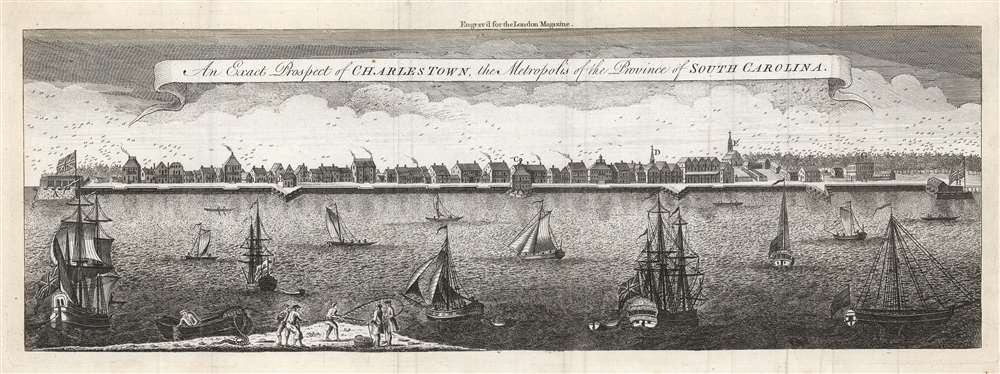

Title
An Exact Prospect of Charlestown, the Metropolis of the Province of South Carolina.
1779 (undated) 6.75 x 20 in (17.145 x 50.8 cm)
1779 (undated) 6.75 x 20 in (17.145 x 50.8 cm)
Description
FOR THE ORIGINAL ANTIQUE MAP, WITH HISTORICAL ANALYSIS, CLICK HERE.
Digital Map Information
Geographicus maintains an archive of high-resolution rare map scans. We scan our maps at 300 DPI or higher, with newer images being 600 DPI, (either TIFF or JPEG, depending on when the scan was done) which is most cases in suitable for enlargement and printing.
Delivery
Once you purchase our digital scan service, you will receive a download link via email - usually within seconds. Digital orders are delivered as ZIP files, an industry standard file compression protocol that any computer should be able to unpack. Some of our files are very large, and can take some time to download. Most files are saved into your computer's 'Downloads' folder. All delivery is electronic. No physical product is shipped.
Credit and Scope of Use
You can use your digial image any way you want! Our digital images are unrestricted by copyright and can be used, modified, and published freely. The textual description that accompanies the original antique map is not included in the sale of digital images and remains protected by copyright. That said, we put significant care and effort into scanning and editing these maps, and we’d appreciate a credit when possible. Should you wish to credit us, please use the following credit line:
Courtesy of Geographicus Rare Antique Maps (https://www.geographicus.com).
How Large Can I Print?
In general, at 300 DPI, you should at least be able to double the size of the actual image, more so with our 600 DPI images. So, if the original was 10 x 12 inches, you can print at 20 x 24 inches, without quality loss. If your display requirements can accommodate some loss in image quality, you can make it even larger. That being said, no quality of scan will allow you to blow up at 10 x 12 inch map to wall size without significant quality loss. For more information, it is best consult a printer or reprographics specialist.
Refunds
If the high resolution image you ordered is unavailable, we will fully refund your purchase. Otherwise, digital images scans are a service, not a tangible product, and cannot be returned or refunded once the download link is used.
Cartographer S
Bishop Roberts (? - 1740) was an American artist active in Charlestown, South Carolina. Very little is known of his life, but he advertised his services (portraits, landscapes, heraldry, drawings, engravings; and as well to paint houses) in 1735. He produced a watercolor panorama of the coastline of Charleston sometime between 1735 and 1739. (The original is now held in the Colonial Williamsburg Collection.) A large printed version of this work on four sheets appears to have been engraved by W. H. Toms, which was available as early as 1740. We are aware of one example of this four-sheet panorama to have survived, also at Colonial Williamsburg. Its 1739-40 dating is indicated by announcements printed by Robert’s widow, Mary Roberts, advertising that her husband's subscribers should pick up (and pay for) the prints so that she could settle his estate. Mary Roberts (died 1761) was herself an artist, one of the earliest American miniaturists, and the first recorded woman working in the medium in the colonies. More by this mapmaker...
William Henry Toms (1701 - 1765) was an English engraver, print seller, publisher and stationer active in London during the early to middle 18h century. The son of Peter Toms, Henry apprenticed under John Harris from 1716. He was engraving independently from at least 1726 and his imprint appears on portraits, books plates, landscapes, maps and architectural prints. His name appears on the great Popple map of North America as well as on important maps by Lempriere, Seale, Boulton, Moll, and others. He was imprisoned for debt in 1761. His son, Peter Toms II (1726 - 1777) became a well known painter. His apprentices included the engraver and publisher John Boydell (January, 19 1720 - December 12, 1804). He lived on Masham Street, London. His work also appears as 'Henry William Toms', 'W. H. Toms', and 'Thoms'. Learn More...
Source
Baldwin, R., London Magazine, Or, Gentleman's Monthly Intelligencer... , (London) 1779.
References
OCLC 51121721.