Digital Image: 1843 Blake Nautical Chart or Map of Key West, Florida
ChartKeyWest-blake-1843_d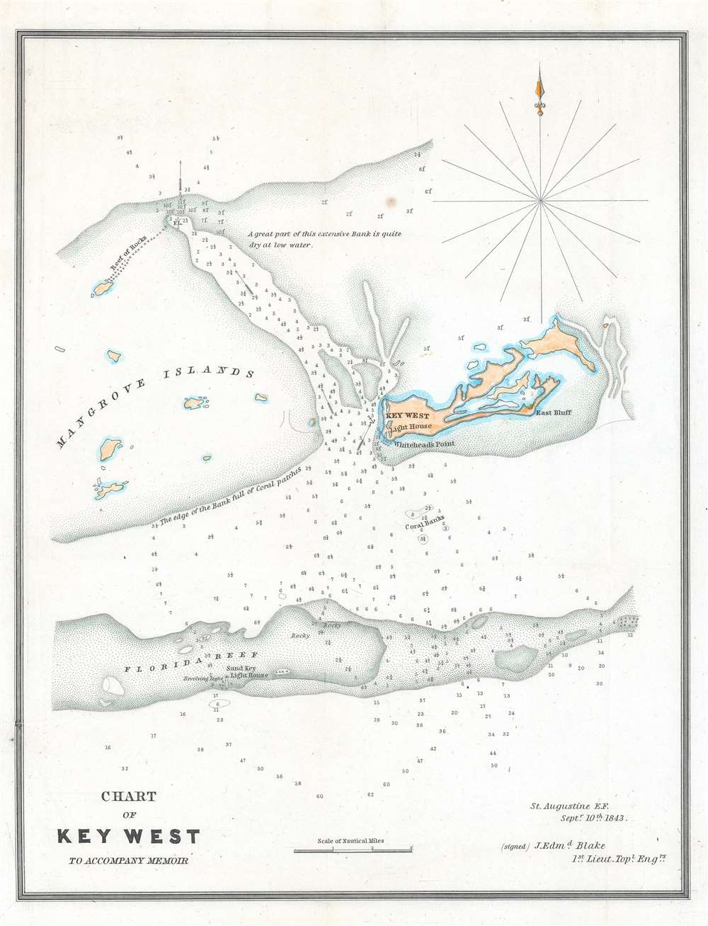

Title
Chart of Key West to Accompany Memoir.
1843 (dated) 12.5 x 9.75 in (31.75 x 24.765 cm) 1 : 130000
1843 (dated) 12.5 x 9.75 in (31.75 x 24.765 cm) 1 : 130000
Description
FOR THE ORIGINAL ANTIQUE MAP, WITH HISTORICAL ANALYSIS, CLICK HERE.
Digital Map Information
Geographicus maintains an archive of high-resolution rare map scans. We scan our maps at 300 DPI or higher, with newer images being 600 DPI, (either TIFF or JPEG, depending on when the scan was done) which is most cases in suitable for enlargement and printing.
Delivery
Once you purchase our digital scan service, you will receive a download link via email - usually within seconds. Digital orders are delivered as ZIP files, an industry standard file compression protocol that any computer should be able to unpack. Some of our files are very large, and can take some time to download. Most files are saved into your computer's 'Downloads' folder. All delivery is electronic. No physical product is shipped.
Credit and Scope of Use
You can use your digial image any way you want! Our digital images are unrestricted by copyright and can be used, modified, and published freely. The textual description that accompanies the original antique map is not included in the sale of digital images and remains protected by copyright. That said, we put significant care and effort into scanning and editing these maps, and we’d appreciate a credit when possible. Should you wish to credit us, please use the following credit line:
Courtesy of Geographicus Rare Antique Maps (https://www.geographicus.com).
How Large Can I Print?
In general, at 300 DPI, you should at least be able to double the size of the actual image, more so with our 600 DPI images. So, if the original was 10 x 12 inches, you can print at 20 x 24 inches, without quality loss. If your display requirements can accommodate some loss in image quality, you can make it even larger. That being said, no quality of scan will allow you to blow up at 10 x 12 inch map to wall size without significant quality loss. For more information, it is best consult a printer or reprographics specialist.
Refunds
If the high resolution image you ordered is unavailable, we will fully refund your purchase. Otherwise, digital images scans are a service, not a tangible product, and cannot be returned or refunded once the download link is used.
Cartographer
Jacob Edward Blake (January 17, 1812 - May 9, 1846) was an American army officer and engineer. A native of Pennsylvania, Blake attended the United States Military Academy at West Point from July 1, 1829 until July 1, 1833, when he graduated and was commissioned as a brevet second lieutenant in the 6th U.S. Infantry Regiment. He was promoted to second lieutenant on July 31, 1836, and first lieutenant on September 6, 1837. He joined the newly created Corps of Topographical Engineers on July 7, 1838, where he would spend the rest of his U.S. Army career. He served in Florida during the Second Seminole War in 1838 and 1839, and then worked constructing harbors on Lake Erie from 1839 until 1841. Then, he was part of the team that surveyed the U.S.-Texas border in 1841 and 1842. Blake returned to Florida in 1842 to served on brevet Brigadier General William J. Worth's staff as the leader of its survey team. Blake worked on surveys of Florida for three years, until he was transferred to General Zachary Taylor's army in 1845. Blake served with distinction during the Mexican American War (1846 - 1848). In his official report, General Taylor mentioned Blake's daring reconnaissance of the Mexican lines before the Battle of Palo Alto (May 8, 1846). Blake spent nearly twenty-four hours in the saddle during and after the Battle of Palo Alto. After returning to camp, Blake was unsaddling his horse when his holsters hit the ground and his gun went off. The ball struck him, and he died a few hours later. More by this mapmaker...
References
OCLC 233986066.