Digital Image: 1875 Smith Map of the American Civil War Battles around Chattanooga, Tennessee
Chattanooga-smith-1875_d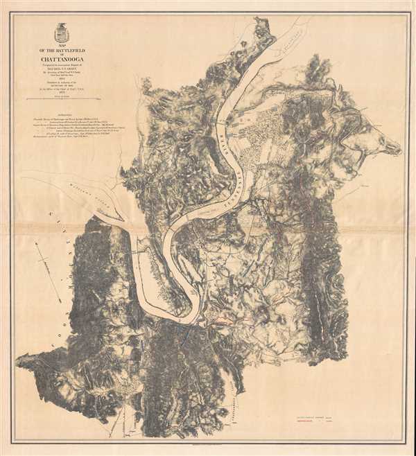

Title
Map of the Battlefield of Chattanooga. Prepared to accompany Report of Maj. Gen. U.S. Grant by direction of Brig. Gen. W.F. Smith.
1875 (dated) 29 x 26.75 in (73.66 x 67.945 cm) 1 : 27500
1875 (dated) 29 x 26.75 in (73.66 x 67.945 cm) 1 : 27500
Description
FOR THE ORIGINAL ANTIQUE MAP, WITH HISTORICAL ANALYSIS, CLICK HERE.
Digital Map Information
Geographicus maintains an archive of high-resolution rare map scans. We scan our maps at 300 DPI or higher, with newer images being 600 DPI, (either TIFF or JPEG, depending on when the scan was done) which is most cases in suitable for enlargement and printing.
Delivery
Once you purchase our digital scan service, you will receive a download link via email - usually within seconds. Digital orders are delivered as ZIP files, an industry standard file compression protocol that any computer should be able to unpack. Some of our files are very large, and can take some time to download. Most files are saved into your computer's 'Downloads' folder. All delivery is electronic. No physical product is shipped.
Credit and Scope of Use
You can use your digial image any way you want! Our digital images are unrestricted by copyright and can be used, modified, and published freely. The textual description that accompanies the original antique map is not included in the sale of digital images and remains protected by copyright. That said, we put significant care and effort into scanning and editing these maps, and we’d appreciate a credit when possible. Should you wish to credit us, please use the following credit line:
Courtesy of Geographicus Rare Antique Maps (https://www.geographicus.com).
How Large Can I Print?
In general, at 300 DPI, you should at least be able to double the size of the actual image, more so with our 600 DPI images. So, if the original was 10 x 12 inches, you can print at 20 x 24 inches, without quality loss. If your display requirements can accommodate some loss in image quality, you can make it even larger. That being said, no quality of scan will allow you to blow up at 10 x 12 inch map to wall size without significant quality loss. For more information, it is best consult a printer or reprographics specialist.
Refunds
If the high resolution image you ordered is unavailable, we will fully refund your purchase. Otherwise, digital images scans are a service, not a tangible product, and cannot be returned or refunded once the download link is used.
Cartographer S
William Farrar 'Baldy' Smith (February 17, 1824 - February 28, 1903) was an American military officer and a Union general during the American Civil War. Born in St. Albans, Vermont, Smith entered the United States Military Academy at West Point in 1841 and graduated four years later fourth in his class of forty-one cadets. Upon graduating, Smith was appointed a brevet second lieutenant and assigned to the Corps of Topographical Engineers. He spent his years in the Corps conducting surveys of the Great Lakes, Texas, Arizona, Florida, and much of Mexico. He also worked for the lighthouse service and twice served as an assistant mathematics professor at West Point. During the American Civil War, Smith had a career full of great successes and incredible failures. He was at the First Battle of Bull Run on the staff of Brigadier General Irvin McDowell, and soon was recognized for gallantry at the Battle of White Oak Swamp in the Seven Days Battles. Smith also led his division with 'conspicuous valor' during the Battle of Antietam. Due to his accomplishments, Smith was promoted to command of the VI Corps of the Army of the Potomac when his corps commander was reassigned to a superior command. This, however, was disastrous for Smith and escaped being being dismissed by General Burnside, along with several other senior officers, when President Lincoln countermanded Burnside's order and, instead, removed him from command. Smith, having made the decision to stay in the Army, nonetheless faced the reality that the Senate did not confirm his promotion to major general, meaning that he reverted back to the rank of brigadier general and took over command of a division of militia in Pennsylvania. It was with this militia unit that Smith repelled an attack by Major General J.E.B. Stuart during the Gettysburg Campaign. In October 8163, Smith was reassigned to duty as the chief engineer of the Army of the Cumberland, and soon would be the chief engineer of the Military District of the Mississippi. Smith was responsible for opening what became known as the 'Cracker Line' to supply besieged Union troops in Chattanooga, which won him his promotion of major general in March 1864. During the Overland Campaign of 1864, Grant assigned Smith to common the XVIII Corps in the Army of the James. In this command he led his troops in the Battle of Cold Harbor and in the first operations against Petersburg. At Petersburg, Smith again suffered a setback, when he waited too long to seize an opportunity to attack the city, which cost the Union Army a chance to shorten the war by nearly a year. He was relieved of command in July 1864, and spent the rest of the war on 'special duty'. After the was was over, Smith resigned from the volunteer army in 1864 and the regular army in 1867. He was President of the International Telegraph Company from 1864 until 1873 and served on the board of police commissioners of New York City from 1875 until 1881. After 1881, Smith began working on civil engineering projects in Pennsylvania, and died in Philadelphia in 1903. More by this mapmaker...
Graphic Company (1872 - 1890), or The Graphic Company, was a New York City based printing house in the latter half of the 19th century. The company was founded by the brothers James H. Goodsell and C. M. Goodsell. The Goodsell Brothers were born in Michigan and, for a time, ran a printing business in Chicago, which they lost during the 1871 Great Chicago Fire. They moved to New York in 1872, drawing investors and founding The Graphic Company with $500,000 USD in investment capital, much of it from Canada where it was publically traded. Among their investors were the prominent Republicans Alexander Robey 'Boss' Shepherd and Benjamin Franklin Butler. It was originally created as a newspaper, The Daily Graphic, but quickly expanded to other forms of printing. In 1873, they concocted a publicity stunt to build a giant branded balloon to send aeronauts John Wise and Washington H. Donaldson across the Atlantic in just 60 hours – an attempt that ended in disaster in a Connecticut field just 120 miles from its starting point. By 1874, The Graphic Company advertised as general lithographers, engravers, and power press printers, with specializations in commercial lithography (stock certificates, checks, notes, etc), presentation cards, chromolithography, and photo-lithography. Within a year, they had become a large and successful printing house, largely due to large government printing contracts that may have been dubiously obtained, possibly through investors Sherman and Butler. In 1878, they introduced an additional periodical, The Weekly Graphic. The Goodsells sold their shares in The Graphic Company by at least 1886. By 1888, the company changed its name to the American Graphic Company. In 1889, it was advertised as the Graphic Publishing Company. For most of its operation, the company was located at 39-41 Park Place, New York. The firm was dissolved by court order in March of 1890. The Goodsell Brothers were also, from 1872, publishers of the Financier, a successful financial journal based at 156 and 158 Broadway, and the Insurance Spectator. Learn More...
References
LOC G3964.C3S5 1875 .S61 CW 406. Stephenson, R. W., Civil War Maps; an Annotated List of Maps and Atlases in Map Collections of the Library of Congress, 406. OCLC 144230211.