This item has been sold, but you can get on the Waitlist to be notified if another example becomes available, or purchase a digital scan.
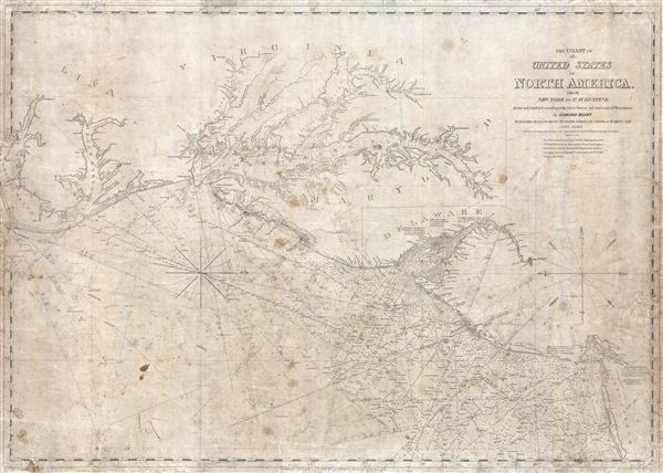
1851 Blunt Nautical Map of The Chesapeake Bay, Delaware Bay, and Albemarle Sound
ChesapeakeBay-blunt-1851$350.00

Title
The Coast of the United States of North America, from New York to St. Augustine drawn and regulated according to the best Surveys and Astronomical Observations by Enmund Blunt.
1851 (dated) 27 x 38 in (68.58 x 96.52 cm) 1 : 703800
1851 (dated) 27 x 38 in (68.58 x 96.52 cm) 1 : 703800
Description
An interesting 1851 Edmund Blunt maritime chart or nautical map of the coast of the United States between New York City and the Pamlico Sound. Centered on the Chesapeake Bay, which is rendered in full, this map offers a fine pre-U.S. Coast Survey analysis of the American coast including the Pamlico Sound, the Albemarle Sound, The Chesapeake Bay and its Rivers, the Delaware Bay, and the New Jersey coastline. The map extends inland as far as Washington D.C. The chart includes numerous depth soundings throughout as well as notes on lighthouse, shoals, and various other undersea dangers. This map appears to have seen considerable use and has numerous pencil markings related to navigation throughout. A scarce map.
Cartographer
Edmund March Blunt (June 20, 1770 - 1862) was an American navigator, bookseller, chartmaker, and cartographer based in Newburyport, Massachusetts. Blunt was born in Portsmouth, New Hampshire in 1770. In 1796, along with the nominal assistance of prominent navigator Captain Lawrence Furlong, Blunt published The American Coast Pilot, one of the most important published works on American navigation. Although much of the work was plagiarized from British publications, the Coast Pilot was an immediate popular success. In response to the popularity of his work, Blunt published 21 subsequent editions, each with important updates and revisions. The first edition to contain map plates was printed in 1804. Following a fire that destroyed his offices at The Sign of the Bible in 1811, Blunt moved his business to New York and opened a new shop, The Sign of the Quadrant. His sons Edmund Jr. (1799 - 1866) and George William (1802 - 1878), joined the firm in 1824 and eventually took over the family business, renaming the firm 'E. and G. W. Blunt'. They both produced their own nautical books, charts, and instruments, as well as republished their father’s work. In 1830, Edmund accepted a position under Ferdinand Hassler at the United States Office of the Coast Survey. Much of Blunt's original work eventually found its way into U.S. Coast Survey Publications. George closed the firm in 1872 and sold the plates and chart copyrights to the U.S. Coast Survey and the U.S. Navy Hydrographic Office. Due to the quality and detail of Blunt's work, revised editions of his most important charts were republished well into the 1880s. More by this mapmaker...
Condition
Average. Map exhibits soiling throughout as well as numerous pencil marking associated with early navigational use. Map has been professionally repaired and backed with archival tissue.