1913 Fairchild Map of Chester Heights, Mount Vernon, New York
ChesterHeights-fairchild-1913$500.00

Title
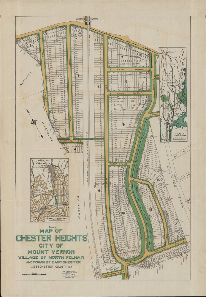
Sales Map of Chester Heights City of Mount Vernon Village of North Pelham and Town of Eastchester Westchester County N.Y.
1913 (dated) 18.25 x 12 in (46.355 x 30.48 cm) 1 : 1850
1913 (dated) 18.25 x 12 in (46.355 x 30.48 cm) 1 : 1850
Description
An unrecorded promotional cadastral map of the Chester Heights neighborhood of Mount Vernon, New York, prepared in 1913 by John F. Fairchild. It was produced as Mount Vernon and other nearby suburbs were growing rapidly due largely to new commuter train routes to New York City, including the New York, Westchester, and Boston Railway seen here.
Aside from residential lots and the railway, roads, greenspace, the Hutchinson River, and a proposed trolley along New Rochelle Rd. are labeled. Two insets appear; a railroad location map at top-right, showing the routes of the New York, Westchester, and Boston Railway and other lines, and a street location map, displaying a wider area than the main map.
A Closer Look
Oriented towards the northwest, this map marks lots for sale in the Chester Heights neighborhood in the extreme northeastern corner of Mount Vernon. Today, this area is well-traversed by motorists interchanging between the Hutchinson River Parkway and Cross-County Parkway, but these roads were only initially constructed in the 1920s, with the Hutchinson River Parkway closely following the path of its namesake river and Hutchinson Blvd. and the Cross-County Parkway running north-south just to the west of the area seen here. Conversely, the New York, Westchester, and Boston Railway seen here and its Chester Heights Station at top (and Lincoln Avenue Station referred to at bottom) were defunct by the 1930s, and its right of way was incorporated into the residential lots along Hillcrest Road and Alta Drive. In other respects, the ultimate layout and name of streets did not exactly follow this plan, especially at bottom, but the general layout of the neighborhood conforms to that seen here.Aside from residential lots and the railway, roads, greenspace, the Hutchinson River, and a proposed trolley along New Rochelle Rd. are labeled. Two insets appear; a railroad location map at top-right, showing the routes of the New York, Westchester, and Boston Railway and other lines, and a street location map, displaying a wider area than the main map.
The New York, Westchester, and Boston Railway
The New York, Westchester, and Boston Railway was an electric commuter railroad that operated in the Bronx and Westchester County between 1912 and 1937. Backed by J. P. Morgan, the railway matched the enthusiasm and ambitions of the growing 'bedroom communities' on the periphery of New York City, with ornate stations including marble interiors, relatively luxurious cars, a level grade, and minimal street crossings. It provided a smooth and easy ride to a station at E. 180th Street in the Bronx, where connection was provided to the Interborough Rapid Transit Company Third Avenue Line, and onwards to E. 132nd St. and Willis Ave, with a shuttle and walkway connection to the 129th Street station of the Second and Third Avenue elevated lines. Even more impressively, fares were less expensive than competitors. However, competing lines, namely the New York, New Haven and Hartford Railroad (also financed by J. P. Morgan), offered a direct route to Grand Central Station. The rise of automobiles also dramatically hurt passenger numbers, and by the mid-1930s, the New York, Westchester, and Boston was bankrupt. Eventually, the Bronx portion of the tracks became the IRT Dyre Avenue Line, now part of the NYC Subway's 5 Line. The rest of the line was dismantled and scrapped to support the war effort during World War II.The Growth of Westchester
Westchester County became a popular destination for upwardly mobile residents of, or migrants to, New York City in the late 19th and early 20th century for several reasons. The city was crowded, dirty, polluted, and, until public health measures were instituted, a hotbed of infectious disease. Suburbs, on the other hand, were seen as spacious, healthful, and rejuvenating (especially at the heights of the Garden City Movement). Moreover, new train lines, many now incorporated into the New York City Subway system or the Metro-North Railroad, and, eventually, automobiles, provided easy transportation to and from the city. The result was that real estate developers and investors bought up large tracts of land in Westchester County, planning out subdivisions and even entire towns, selling the lots, and constructing the buildings in just a few years. For example, Mount Vernon's population grew from roughly 4,500 in 1880 to over 10,000 by 1890, with more than 10,000 new residents added in each of the following three decades.Publication History and Census
This map was prepared by John F. Fairbank, a local civil engineer, in 1913. It is unrecorded in institutional collections and has no known history on the market.Cartographer
John F. Fairchild (c. 1868 - 1943) was a civil engineer and surveyor based in Mount Vernon, New York. Fairchild was born in Washington, D.C. and attended Central High School. Little is known of his upbringing or training, but he appears to have begun work as a civil engineer in Washington, D.C. around 1888. In 1890, he relocated to Mount Vernon, New York. Although he worked for the Bronx Valley Sewer Commission in the mid-1890s, most of his maps were cadastral maps of real estate lots being sold in growing neighborhoods and suburbs of Washington, D.C. and New York City. In 1899, he produced an Atlas of the City of Mount of Vernon and the Town of Pelham. Fairchild served as a major in the U.S. Army Corps of Engineers in the First World War. In 1930, he retired and relocated to Harrington Park, New Jersey, where he died in 1943. More by this mapmaker...
Condition
Very good. Light wear along original folds. Light offsetting.