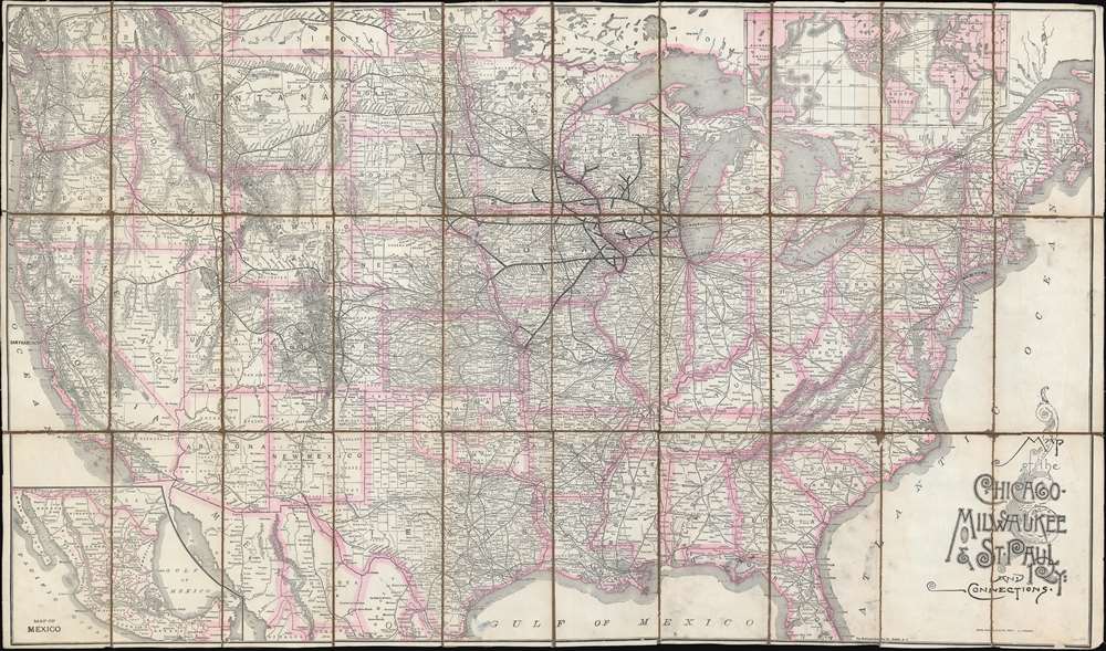
1893 Rand McNally Map of the Chicago, Milwaukee, and St. Paul Railway
ChicagoMilwaukeeStPaulRR-randmcnally-1893$1,500.00


Title
Map of the Chicago, Milwaukee and St. Paul Ry: and connections.
1893 (undated) 22 x 39 in (55.88 x 99.06 cm) 1 : 10700000
1893 (undated) 22 x 39 in (55.88 x 99.06 cm) 1 : 10700000
Description
This is a large format 1893 railroad map of the United States illustrating the Chicago, Milwaukee and St. Paul Railway, and its national connections. The map is a significant deviation from earlier maps of the same title in that in covers the United States from coast to coast. At the time, the directors of the Chicago, Milwaukee and St. Paul Railway were concerned by competition from the Northern Pacific, which offered enviable coast-to-cost service. While the directors ultimately sanctioned the development of their own Pacific line, it took until 1909 to be put into operation. In the meantime, the Chicago, Milwaukee, and St. Paul Railway needed to compete. This map illustrates possible connections available to passengers on the Chicago, Milwaukee, and St. Paul Railway, including access to steamship routes to Europe, China, and Australia, and railroad routes in Mexico.
Chicago, Milwaukee, St. Paul Railroad
The Chicago, Milwaukee, St. Paul Railroad, commonly known as the Milwaukee Railroad, was a rail network operated in the American Midwest from 1847 to 1980. It was founded as the Milwaukee and Waukesha Railroad in Wisconsin, where it was intended to link Milwaukee (and Lake Michigan) to the Mississippi River. In 1850, the name changed to the Milwaukee and Mississippi Railroad, when construction of the initial line began. Between 1850 and 1857 extension lines were added to Waukesha (1851), Madison, and Prairie du Chien (1857), which finally completed the dream of connecting Milwaukee to the Mississippi. In 1874, the railway absorbed the Chicago and Pacific Railroad, changing its name to the Chicago, Milwaukee and St. Paul Railway. By 1887, the railroad had lines extending service to Wisconsin, Minnesota, Iowa, South Dakota, and Michigan's Upper Peninsula.Historical Context for Railroad Competition
Between 1884 and 1890 the railroad suffered serious competition from the Northern Pacific, which offered superior access to the West Coast. The railroad directors thus developed a plan to extending their line all the way to the Pacific - no doubt inspiring this coast-to-coast map. Work on the Pacific Extension, which was estimated at 45 million USD, the equivalent of 1.35 billion in modern dollars, began in 1901 and was completed in 1909. The line ran mostly parallel to the Northern Pacific but was slightly shorter. Ultimately, the extension cost some 235 million USD, more than four times the initial estimate, pushing the railroad into insolvency by 1925. It was resurrected several times, but finally terminated all service in 1980.Publication History and Census
The map was published jointly by Matthews Northrup and Rand McNally in Chicago on behalf of the railroad. There appear to be several editions with the same title, some dating from the 1870s and others dating as late as 1902. We have been unable to secure images of all editions, but those we have found suggest that the map was massively retooled and redesigned with each publication. The OCLC lists several examples, but upon further investigation, most of these appear to be digital listings tracing back to the David Rumsey example at Stanford. We note verifiable holdings at Stanford, Princeton, and the University of Michigan. We have been able to identify no market history.CartographerS
Rand, McNally and Co. (fl. 1856 - present) is an American publisher of maps, atlases and globes. The company was founded in 1856 when William H. Rand, a native of Quincy, Massachusetts, opened a print shop in Chicago. Rand hired the recent Irish immigrant Andrew McNally to assist in the shop giving him a wage of 9 USD per week. The duo landed several important contracts, including the Tribune's (later renamed the Chicago Tribune) printing operation. In 1872, Rand McNally produced its first map, a railroad guide, using a new cost effective printing technique known as wax process engraving. As Chicago developed as a railway hub, the Rand firm, now incorporated as Rand McNally, began producing a wide array of railroad maps and guides. Over time, the firm expanded into atlases, globes, educational material, and general literature. By embracing the wax engraving process, Rand McNally was able to dominate the map and atlas market, pushing more traditional American lithographic publishers like Colton, Johnson, and Mitchell out of business. Eventually Rand McNally opened an annex office in New York City headed by Caleb S. Hammond, whose name is today synonymous with maps and atlases, and who later started his own map company, C. S. Hammond & Co. Both firms remain in business. More by this mapmaker...
Matthews-Northrup Works (fl. c. 1895 - 1930) were a Buffalo, New York based, in their own words, "writing, designing, engraving, printing, [and] binding" firm. The firm was founded by James Newson Matthews (November 21, 1828 - December 20, 1888) as the J. N. Matthews Company. William Phelps Northrup (April 2, 1850 - February 2, 1929) later joined the company as an apprentice and then partner, at which point the firm was reincorporated as the Matthews-Northrup Works. The Matthews-Northrup Works rose to prominence as publishers and printers of railroad maps, with dozens to their credit. When James died, his shares were inhered by George Edward Matthews (1855 - 1910), who ran the business until his death in 1910. Also in 1910, they famously redesigned the cover of National Geographic Magazine. Despite some six previous cover changes in just 21 years, the Matthews-Northrup layout proved so popular that it was used for nearly 50 years. The firm can also take credit for the Winchell typeface, designed in 1903 under E. E. Winchell's tenure as art director. Curiously, the partners of Matthews-Northrup maintained an unusual affectation in which only the officers of the company could wear beards or mustaches. In this same spirit, the firm also had its own private social club, the Fellowcraft Club, where the all-male employees could relax, play pool, drink and dine. Matthews-Northrup maintained offices on Washington Street, Buffalo, where they were based, as well as Madison Square, New York City, Garden Tower, Boston, and the Citizens Building in Cleveland. Learn More...
Condition
Good. Dissected and mounted on original linen in thirty (30) panels. Some loss at fold intersections. Linen is weak in certain sections.
References
OCLC 53343040. Rumsey 5247.001.