1661 Elzevir / Cluver map of China, Korea and Japan
China-elzevir-1661$250.00

Title
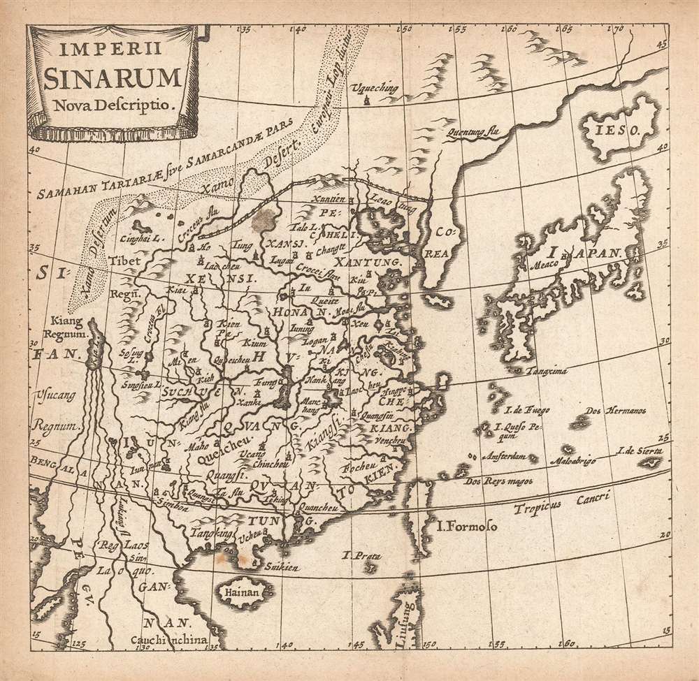
Imperii Sinarum Nova Descriptio.
1661 (undated) 4.75 x 5 in (12.065 x 12.7 cm) 1 : 72351000
1661 (undated) 4.75 x 5 in (12.065 x 12.7 cm) 1 : 72351000
Description
This is a finely-engraved miniature map of China, Korea and Japan, printed in a 1661 Elzevir edition of Philipp Cluver's introduction to geography. Cluver's work appeared in editions produced by many different houses, and with maps of wildly differing characteristics.
The Map
The map's detail is primarily focused on China itself. The Great Wall is shown; points north of it include the Gobi Desert (Xamo) and reference to the kingdom of Samarkand. Korea appears with little detail, but is represented as a peninsula - correcting the long, erroneous insular Korea myth. Japan is recognizable; the proto-Hokkaido (Ieso) appears correctly as an island, rather than as part of the Asian mainland as it often would through the latter 17th and the 18th centuries. In these respects, this map follows the model of Joan Blaeu's 1655 map of the same title, as did the China map appearing in the 1661 Conrad Buno edition of Cluver. However, while the place names match closely, the Elzevir edition is executed better than the Buno, whose lettering is childlike, and approaching illegible in comparison. The Elzevir, particularly considering the workaday source, is an extremely artful piece, exhibiting expert engraving with an even, light hand. Even the simple cartouche of this example is more elegantly and artistically rendered than the clumsy, blockish cartouche of the Buno.Apocryphal Lake Chiamay
At the western extreme of the map, north of what would become Burma appears the mythical Lake of Chiamay (Xia L. on the map). roughly in what is today Assam, India. Sixteenth and Seventeenth century cartographers postulated that such a lake must exist to source the four important Southeast Asian river systems: the Irrawaddy, the Dharla, the Chao Phraya, and the Brahmaputra. This lake began to appear in maps of Asia as early as the 16th century and persisted well into the mid-18th century. Its origins are unknown but may originate in a lost 16th century geography prepared by the Portuguese scholar Joao de Barros. It was also heavily discussed in the journals of Sven Hedin, who believed it to be associated with Indian legend that a sacred lake, Mansarovar, linked several of the holy subcontinent river systems. There are even records that the King of Siam led an invasion to take control of the lake in the 16th century. Nonetheless, the theory of Lake Chiamay was ultimately disproved, and it disappeared from maps entirely by the 1760s.A Mystery Engraver? A Woman?
None of the maps appearing in the Elzevir edition of Cluver's Introductionis in universam geographiam are signed by an engraver. For a miniature map, this is not unusual - very often this work was executed by journeyman engravers, who would not have the right to apply their imprint. However, it is very possible that the matriarch of the Elzevir firm - Eva van Alphen - did this work herself. She is known to have been an accomplished engraver, having been credited with a beautiful Dutch Bible map after Visscher (Orbis Terrarum Tabula Recens Emendata et in Lucem Edita per N. Visscher). At the time their Cluver was produced, Eva's husband Jean was in failing health and upon his 1661 death she took over direction of the firm. The excellent work here may well be hers.Publication History and Census
The map was engraved for inclusion in Philipp Cluver's Introductionis in universam geographiam, as early as 1659. Though he did not live to see it in print, Cluver's text became one of the most popular of the seventeenth century, printed in many editions from 1624 through the 18th century. This example appeared in a 1661 edition of the book, published by the house of Elzevir. This edition of Cluver is noted in 15 examples in OCLC; the separate map is not catalogued.CartographerS
Philipp Clüver (also Klüwer, Cluwer, or Cluvier, Latinized as Philippus Cluverius and Philippi Cluverii) (1580 - December 31, 1622) was a German geographer and historian active in Leiden in the late 16th and early 17th centuries. Clüver was born in the Royal Prussian city of Danzig (Gdansk), then a province of the Kingdom of Poland. He study of law at the University of Leiden before turning his attention to history and geography. Cluver traveled, mostly by foot, extensively throughout Europe, spending time in Germany, England, Scotland, Holland and Italy. On returning to Leiden he was given a special appointment as geographer and put in charge of the university's library. Cluver is best known for his general study of the geography of antiquity. A popular Enlightenment era field of study, antiquarian geography attempted to resolve place names known from classical literature but, by the time of the Renaissance, geographically confused. Cluver based his research not only on classical literary sources, but — and this was his primary contribution to the genre — also his extensive and local inspections of sites. Today he is considered one of the founding fathers of historical geography. Cartographically Cluver's most prominent works include his edition of Ptolemy's Geographia (based on Mercator's edition of 1578) and for miniature atlases that were reprinted for most of the 17thand 18th centuries. Cluver was also known as Klüwer, Cluwer, or Cluvier, Latinized as Philippus Cluverius and Philippi Cluverii. He died in Leiden in 1622. More by this mapmaker...
The house of Elzevir (active c. 1600 - 1712) were a celebrated family of Dutch booksellers, publishers, and printers of the 17th and early 18th centuries; their specialty tended to be small - format 'duodecimo' books. The firm came to prominence with the work of Lodweijk, or Louis, Elzevir (1546-1617) who got his start as a bookbinder in Leuven and after some years became a bookseller and publisher in is own right in Leiden. Louis published about 150 works during his lifetime. He had seven sons, five of whom carried on their father's trade. Of these, Bonaventura Elzevir (1583–1652) is the most celebrated. He began publishing in 1608, joined in 1626 by his nephew Abraham Elzevir (1592-1652). In 1617 another nephew, Isaac Elzevir (1596–1651), acquired a press allowing the family business to take over the production end of the publishing process. Abraham's son Jean Elzevir (1622-1661) joined the partnership in 1647; he would carry on the Leiden business until his death in 1661. Jean's wife, Eva van Alphen Elzevier (active 1651-1663; died 1681) then became head of the business, producing work of a very high quality. Bonaventura's son Daniel. (1626-80) would join his cousin Louis' press in Amsterdam in 1654, but many of their productions were actually manufactured at Eva's press in Leyden. It is likely that the quality work of this period can be credited to her: it dropped sharply after her death in 1681, at which point the business fell into the hands of her feckless son Abraham, whose incompetence brought the company to an end with his own death in 1712. Learn More...
Petrus Bertius (November 14, 1565 – October 12, 1629), also known as Peter Bardt and P. Bertii, was a Flemish theologian, historian, and cartographer. Bertius was born in Beveren (Alveringem), a son of the preacher Pieter Michielszoon Bardt. The Bardt family fled to London at the outbreak of the Dutch War of Independence in 1568, fleeing both religious and political strife. When the political situation in the Netherlands stabilized in 1577, Bertius returned to study at the University of Leiden. He supported himself by tutoring until 1593 when he was appointed subregent of the Leiden Statencollege. This was probably a nepotistic post as, in the same year, he married Maritgen Kuchlinus, the daughter of Johannes Kuchlinus, then regent of the Statencollege. Bertius himself succeeded Johannes, becoming regent in 1606. Through his marriage, Bertius associated with Flemish cartographers Jodocus Hondius and Pieter van den Keere, both of whom were in-laws. Bertius first began publishing cartographic works in 1598 when, working with Barent Langenes, he published a the miniature Latin language atlas Tabulae contractae. In 1618, publishing with his brother-in-law Jodocus Hondius, he issued the atlas Theatrum Geographiae Veteris, which impressed Louis XIII of France sufficiently that he relocated to Paris to take position as court cosmographer to the King. Two years later he converted to Catholicism and took a position teaching rhetoric at the Collège de Boncourt, in Paris. In 1622, Louix XIII granted him a chart in mathematical sciences at the royal college and the honorarium of royal historian. Bertius remained in Paris until his death in 1629. Learn More...
Source
Clüver, P., Philippi Cluverii Introductionis in Universam Geographiam (Amsterdam: Elzevir) 1661.
Condition
Very good. Original folds. Small ink or tallow spot. Lightly toned.