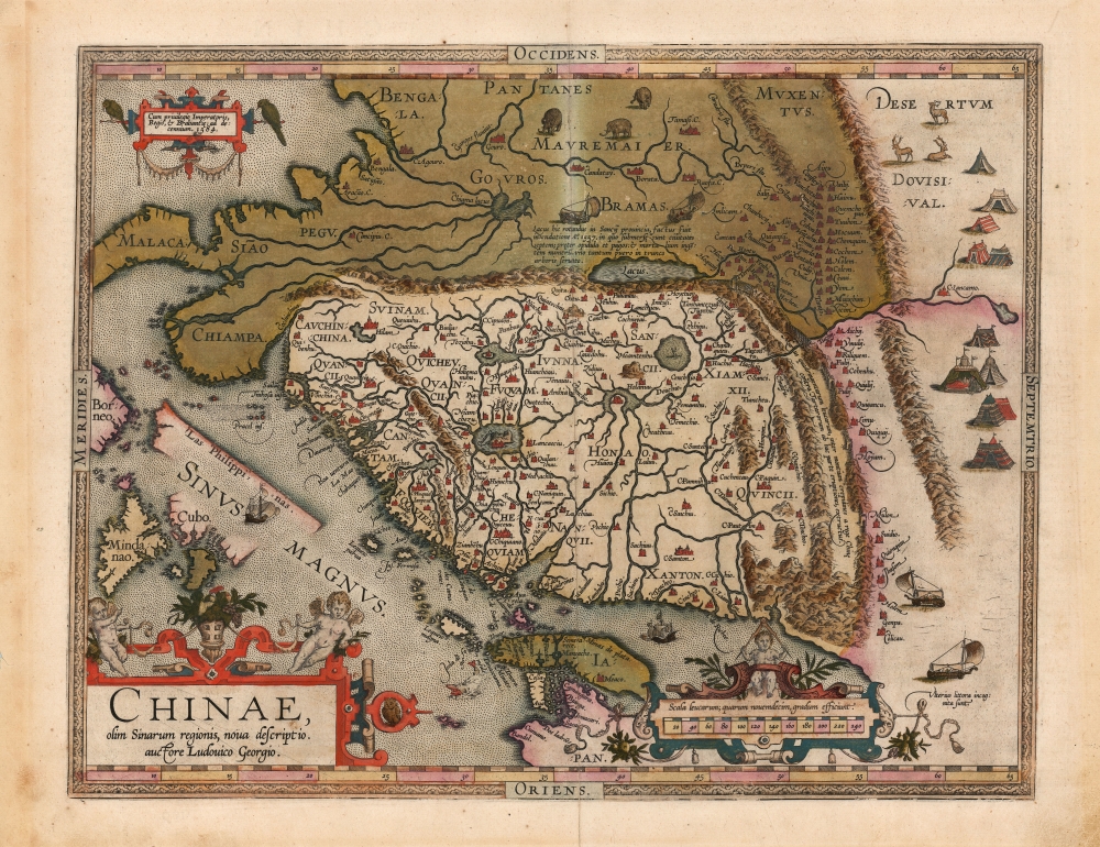
1584/1602 Ortelius Map of China and the Philippines: Original Vrients Color
China-ortelius-1584$6,500.00

Title
Chinae, olim Sinarum regionis, nova descriptio. auctore Ludovico Georgio.
1584 (dated) 17 x 22.5 in (43.18 x 57.15 cm) 1 : 2800000
1584 (dated) 17 x 22.5 in (43.18 x 57.15 cm) 1 : 2800000
Description
This is Abraham Ortelius' 1584 map of China, the first specific map of China to appear in an atlas, here in a beautiful, original-color example of a 1602 Vrients edition. Based on reports of Portuguese missionaries, Ortelius' map was not substantially improved upon until the 1655 maps of Martino Martini (卫匡国; 1614-1661). The map is visually unique, with its western orientation and abundant decorative elements.
It is also the first to depict the Great Wall of China. Though presented impressively, enclosing the whole northern border of China, the wall's size is grossly underestimated in the attendant note: 'A wall of four hundred miles has been constructed between the edges of the mountains by the king of China against the invasions of the Tartars in this part'.
This map contains the first depiction of wind wagons, the sight of which astonished European travelers visiting in the 16th century, but which the Chinese employed as early as the 6th century. The verso text contains the first western printed representation of Chinese characters.
An Array of Firsts
This is the first printed European map specifically of China (not named on the 1522 Fries, which was the first to show the area overall). It is the first map of China to appear in a modern, uniform atlas. It was the first atlas map to name the Philippine Archipelago (the 1578 De Jode applies the name to a single island.) Here, Mindanao and the southern shores of Cebu are shown: further expanses of hypothetical 'islands' are roughed in, but Luzon does not appear. Suarez, in his Early Mapping of Southeast Asia, posits that this depiction derives not from reports of Spanish ships arriving from the east (as did Magellan), but from Portuguese ships arriving from the west and keeping to the coast en route to China.It is also the first to depict the Great Wall of China. Though presented impressively, enclosing the whole northern border of China, the wall's size is grossly underestimated in the attendant note: 'A wall of four hundred miles has been constructed between the edges of the mountains by the king of China against the invasions of the Tartars in this part'.
This map contains the first depiction of wind wagons, the sight of which astonished European travelers visiting in the 16th century, but which the Chinese employed as early as the 6th century. The verso text contains the first western printed representation of Chinese characters.
Portuguese Sources and the 1556 Shaanxi Earthquake
The map's Portuguese sources record the deadliest earthquake in human history through a gauze of error. In Shaanxi province (Sancii) is a round lake with a figure afloat in it, in a prayerful pose. Text refers to the picture:This round lake in the province of Sancii was made by a flood in the year 1557, during which seven cities were submerged, as well as towns and villages, and a very great number of dead people were the result, except for one boy only, who was saved by means of a tree trunk.The story to refers the great 1556 Shaanxi Earthquake - in the aftermath of which there were massive flooding and landslides. The 1556 quake has been estimated at magnitude 8. As many as 830,000 Chinese living in loess caves (yaodongs) on high cliffs were killed as the earthquake initiated a horrific cascade of landslides and floods. Chinese annals describe it:
Mountains and rivers changed places and roads were destroyed. In some places, the ground suddenly rose up and formed new hills, or it sank abruptly and became new valleys. In other areas, a stream burst out in an instant, or the ground broke and new gullies appeared. Huts, official houses, temples, and city walls collapsed all of a sudden.Further flooding occurred for months following the initial earthquake.
Beyond the Wall
Although an abundance of place names appear to the North of the Great Wall, their regularity betrays them as more list than map. Derived largely from Marco Polo, they are presented here in order and without benefit of distances. Pictorially, as well, Polo's reports of tent-dwellers and pavilion-cities are captured.Points East
The Asian coastline north of the wall is marked incognita, and there is no indication of the Korean peninsula - also an indication of Portuguese sources, derived from journeys from the southwest. Japan appears in part, a curved formation typical of Portuguese charts (Ortelius depicts Japan five different ways, on five different maps in the Theatrum, a telling statement on the mystery surrounding the archipelago).Apocryphal Lake Chiamay
The mythical Lake of Chiamay, or Chiang Mai, appears at the western extreme of the map, roughly in what is today Assam, India. Early cartographers postulated that such a lake must exist to source the four major Southeast Asian river systems: the Irrawaddy, the Dharla, the Chao Phraya, and the Brahmaputra. This lake began to appear on maps as early as the 15th century and persisted well into the mid-18th century. The origins of the place name are unknown, but the Portuguese Tomé Pires referred to it in his 1512-15 Suma Oriental. It was also heavily discussed in the journals of Sven Hedin, who believed it to be associated with the Indian legend of another sacred lake, Mansarovar, linked spiritually to several of the subcontinent's sacred river systems. There are even records that the King of Siam led an invasion to take control of the lake in the 16th century. Nonetheless, Lake Chiamay was eventually disproved and disappeared from maps entirely by the 1760s.Publication History and Census
This map was engraved and included in Ortelius' 1584 Theatrum Orbis Terrarum, remaining in all subsequent editions of that work. This example was printed in 1602 for the Spanish edition of the Theatrum, published by Johannes Baptista Vrients, who, as Ortelius' executor, acquired the plates for the atlas after the mapmaker's death. Vrients was keen to improve the atlas and, in addition to expanding the work, is noted for the high quality of the color with which he caused Ortelius' maps to be embellished, as here. Van den Broecke estimates that two hundred and fifty examples of this atlas edition were printed. Perhaps five examples of the Italian edition are cataloged in OCLC. The separate map is well-represented in institutional collections in its various editions.CartographerS
Abraham Ortelius (April 14, 1527 - June 28, 1598) also known as Ortels, was a cartographer, geographer, and cosmographer of Brabant, active in Antwerp. He was the creator of the first modern atlas, Theatrum Orbis Terrarum and is a seminal figure in the history of cartography. Along with Gerard Mercator and Gemma Frisius, he was a founder of the Netherlandish school of cartography. His connections with Spain - culminating in his 1575 appointment as Royal Cartographer to King Phillip II of Spain - gave him unmatched access to Spanish geographical knowledge during a crucial period of the Age of Discovery. Ortelius was born in 1527 in Antwerp. In 1547 he entered the Antwerp Guild of Saint Luke as an illuminator of maps. He began trading in books, prints, and maps, traveling regularly to the Frankfurt book and print fair, where in 1554 he met Mercator. He accompanied Mercator on journeys throughout France in 1560 and it was at this time, under Mercator's influence, that he appears to have chosen his career as a scientific geographer. His first published geographic work appeared in 1564, an eight-sheet cordiform world map. A handful of other maps preceded the 1570 publication of the first edition of the Theatrum Orbis Terrarum, which would prove to be his life work. Appearing with but 53 maps in its first edition, Ortelius' work expanded with new maps added regularly. By 1592, it had 134 maps. Many of Ortelius' maps remained the standard for nearly a century. He traveled extensively, but his genius was as a compiler, locating the best informed maps on which to base his own. His contacts throughout Europe and extending even (via the Portuguese) to the Far East were formidable. Moreover, many of his maps were based on his own scholarship, particularly his historical works. His theories of geography were particularly ahead of his time with respect to the notion of continental drift, the possibility of which he mused on as early as 1596, and which would be proven correct centuries later.
In a sense his greatest achievement was his successful navigation of the religious and political violence endemic to his city throughout his adult life: The Dutch Revolt, or Eighty Years' War (1568 - 1648), fully embroiled Antwerp. Although outwardly and officially recognized as Catholic (Arias Montanus vouched for Ortelius' Catholic orthodoxy prior to his appointment as Royal Geographer), Ortelius was able to separate himself from the religious furor which characterized the war in the low countries. Ortelius showed a glimpse of himself in a letter to a friend, regarding humanist Justus Lipsius: 'I do not know whether he is an adherent of the Pope or a Calvinist, but if he has ears to hear, he will neither be one nor the other, for sins are committed on both sides'. Ortelius' own explorations of Biblical history in his maps, and the Christogram contained in his own motto, suggest him to be a religious man, but his abjuration of political religious authorities mark him as an individualist. His tombstone at St Michael's Præmonstratensian Abbey in Antwerp bears the inscription, Quietis cultor sine lite, uxore, prole. ('served quietly, without accusation, wife, and offspring.') More by this mapmaker...
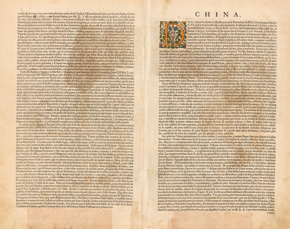
Luiz Jorge de Barbuda (1564? - 1613? ) was a Portuguese cartographer. He is known primarily as the individual credited by Abraham Ortelius as the source for During his 1584 map of China, the first map specifically of China to appear in an atlas. Little is known of his early history and there is little agreement by scholars on his dates. It is understood that he was, in 1582, commissioned by Philip II of Spain to produce navigation charts and world maps. His role as an official cartographer for Spain makes the appearance of his map in Ortelius' atlas all the more remarkable: The Spanish were reluctant to share any of their cartographic information and printed virtually none of it in the 16th and 17th centuries. Nevertheless, his Chinaeappeared in Ortelius' Theatrum Orbis Terrarum accompanied by a brief description of China and its language, derived from Bernardino de Escalante's 1577 Discurso de la navegacion que los Portugueses hacen a los Reinos y Provincias de Oriente, Spain's first book about China. Both the map and the description published in Ortelius' work would remain the most authoritative European description of China until Martini's 1655 work became available. Learn More...
Johannes Baptista Vrients (1552 - 1612) was a Flemish engraver, publisher, and mapseller. Little is known of his early years, but it is to be assumed he came up as an apprentice among the mapmakers of Antwerp, where the guild named him a master in 1575. In the 1590s, he executed world maps for Plancius and Linschoten. (In 1600, after Ortelius died, he became the estate's executor and acquired the plates for the Theatrum.) He would go on to publish further editions of the Ortelius atlas between 1606 and 1612. Vrients also acquired the plates for Gerard De Jode's (1516/17 - 1591) Speculum in and around 1600, but he did not republish that work - though he would preserve the De Jode plates depicting the Electors of the Holy Roman Empire, reprinting it in his editions of the Ortelius atlas after 1603. Most likely, his purchase of the De Jode plates was a play to keep them off the market. Vrients' editions of the Theatrum were not published in Antwerp (that city having fallen during the Dutch war with Spain) but in Amsterdam. Learn More...
Source
Ortelius, A., Theatro del Mondo, (Antwerp: Virents) 1602.
Abraham Ortelius' magnum opus, Theatrum Orbis Terrarum, was the world's first regularly produced atlas, which 'set the standards for later atlases . . . It was the first undertaking of its kind to reduce the best available maps to an uniform format.' (Koeman) A modestly-sized work of fifty-three maps in its first edition of May 1570, it was an immediate success: there were three further editions that year, and the work remained in print for a total of 32 editions, the last of which was 1641, well after its author's 1598 death. Ortelius added to his atlas constantly, and by 1595 the Theatrum contained 147 maps. Ortelius is renowned generally as an editor, and indeed much of the Theatrum is compiled from a variety of sources: in such cases, Ortelius was scrupulous in naming his sources. But Ortelius was also a mapmaker in his own right: many of his maps are a distillation of various sources into his own work, and there were many maps - particularly in his atlas of Biblical and ancient history Parergon - which were entirely Ortelius' work. In his role as an editor, Ortelius followed in the footsteps of Munster, whose Cosmographia was, until Ortelius, the best window on the world for the curious European reader. In terms of the artistry of his maps, Ortelius oversaw the first great flourishing of copperplate engraving in the service of cartography to occur in Northern Europe. Ortelius' work provided the model for the atlases of Mercator, Hondius, Blaeu and all their progeny in the 17th century - many of whom were to produce faithful editions of Ortelius' maps in their own productions.
Condition
Very good. Few marginal mends not impacting printed image. Light toning; else excellent with fine original color.
References
OCLC 710854465. Rumsey 10001.305. Van den Broecke 164.3. Van der Krogt, P. C. J., Koeman's Atlantes Neerlandici, (3 Vols), 31:651. Tibbets G. R., Arabia in Early Maps, map 27, p. 46.