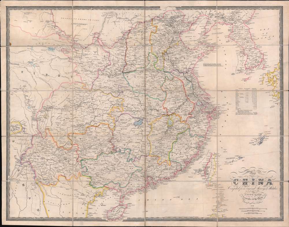
1841 Wyld Map of China (First Opium War)
China-wyld-1841$1,500.00


Title
Map of China Compiled from original Surveys and Sketches.
1841 (dated) 25.5 x 32 in (64.77 x 81.28 cm) 1 : 15000000
1841 (dated) 25.5 x 32 in (64.77 x 81.28 cm) 1 : 15000000
Description
A beautiful example of the scarce 1841 edition of James Wyld's First Opium War Era map of China, with Hong Kong identified here as 'Heong Kong'. This is essentially an early 'newsmap' offering up to date information on the fast-paced war to the invested British public.
The British subsequently dispatched a naval and military force to China. The Royal Navy used its cannon power to inflict a series of decisive defeats on the Qing at various Chinese ports, forcing them to the negotiating table - a tactic later referred to as 'gunboat diplomacy.' When this map was issued, the Qing were forced to sign the Treaty of Nanking, the first of the Unequal Treaties. The Treaty of Nanking created five open treaty ports and ceded Hong Kong to the British Empire. The Opium Trade quickly resumed, but escalating tensions led to the Second Opium War (1856 - 1860) just 14 years later.
A Closer Look
The map covers all of China, extending from the Tibet border to western Japan and from Manchuria to Hainan. Korea, rendered in full, is wildly malformed. Taiwan, appearing near the cartouche, is misshaped, and only the western coast features any detail. There are notes on industry, transportation networks, the Great Wall, population, trade resources, and more.The First Opium War
The First Opium War, or the Anglo-Chinese War (1839 - 1842), was a series of engagements fought between the United Kingdom and Qing China over trade and diplomatic relations. By the middle of the 19th century, an enormous trade imbalance had developed between Europe and China due to the high demand for Chinese goods (silk, porcelain, tea) in Europe and the low demand for European goods (English wool, anyone?) in China. To balance the trade, the British East India Company introduced Indian-grown opium to the Chinese market. The opium trade led to waves of addiction throughout China and reversed the trade imbalance within a couple of years.Historical Context
In 1839, China's Daoguang Emperor, seeking to stem the tide of narcotic addiction, banned opium entirely and blockaded China's only open trade port, Canton (modern-day Guangzhou). They also seized and destroyed nearly 20,000 chests, roughly 1200 tons, of opium. Foreign traders within Canton were confined to their offices without access to outside food or supplies - forcing a 'capitulate or starve' situation.The British subsequently dispatched a naval and military force to China. The Royal Navy used its cannon power to inflict a series of decisive defeats on the Qing at various Chinese ports, forcing them to the negotiating table - a tactic later referred to as 'gunboat diplomacy.' When this map was issued, the Qing were forced to sign the Treaty of Nanking, the first of the Unequal Treaties. The Treaty of Nanking created five open treaty ports and ceded Hong Kong to the British Empire. The Opium Trade quickly resumed, but escalating tensions led to the Second Opium War (1856 - 1860) just 14 years later.
War and Trade
The First Opium War was essentially about trade, as is this map. Wyld offers a wealth of detail regarding trading and resources throughout China. He identifies black tea regions, green tea regions, cotton fields (near Shanghai), chinaware manufactories, silkworm lands, varnish trees, rice grounds, limestone, blue nankeen manufactories, and a place where 'silken fowls are bread.'Wyld's News Maps
Wyld was masterful at capturing political events throughout the world as they occurred and leveraging his impressive publishing operation to quickly produce and distribute pertinent maps to the invested public. The speed with which Wyld could assess news events and produce an informative, fully engraved map contributed significantly to his commercial success. While a small subset of his large cartographic corpus, Wyld's news maps arguably represent his most significant work - forming a vital record of currently developing events from an even-handed, if Anglo-centric perspective. Such maps had an ephemeral period of interest, were separately issued, and necessarily printed in small quantities, leading to their extreme scarcity today.Publication History and Census
James Wyld first published this map in 1840 to capitalize on British public interest in the First Opium War (1839 - 1842). Subsequent editions were issued in 1841 (present example), 1842, 1843, and 1844. Early editions are rare on the market.Cartographer
Wyld (1823 - 1893) was a British publishing firm active throughout the 19th century. It was operated by James Wyld I (1790 - 1836) and his son James Wyld II (November 20, 1812 - 1887) were the principles of an English mapmaking dynasty active in London during much of the 19th century. The elder Wyld was a map publisher under William Faden (1749 - 1836) and did considerable work on the Ordinance Survey. On Faden's retirement in 1823, Wyld took over Faden's workshop, acquiring many of his plates. Wyld's work can often be distinguished from his son's maps through his imprint, which he signed as 'Successor to Faden'. Following in his father's footsteps, the younger Wyld joined the Royal Geographical Society in 1830 at the tender age of 18. When his father died in 1836, James Wyld II was prepared to fully take over and expand his father's considerable cartographic enterprise. Like his father and Faden, Wyld II held the title of official Geographer to the Crown, in this case, Queen Victoria. In 1852, he moved operations from William Faden's old office at Charing Cross East (1837 - 1852) to a new, larger space at 475 Strand. Wyld II also chose to remove Faden's name from all of his updated map plates. Wyld II continued to update and republish both his father's work and the work of William Faden well into the late 1880s. One of Wyld's most eccentric and notable achievements is his 1851 construction of a globe 19 meters (60 feet) in diameter in the heart of Leicester Square, London. In the 1840s, Wyld also embarked upon a political career, being elected to parliament in 1847 and again in 1857. He died in 1887 following a prolific and distinguished career. After Wyld II's death, the family business was briefly taken over by James John Cooper Wyld (1844 - 1907), his son, who ran it from 1887 to 1893 before selling the business to Edward Stanford. All three Wylds are notable for producing, in addition to their atlas maps, short-run maps expounding upon important historical events - illustrating history as it was happening - among them are maps related to the California Gold Rush, the New South Wales Gold Rush, the Scramble for Africa, the Oregon Question, and more. More by this mapmaker...
Condition
Very good. Original linen stable.
References
OCLC 4577124.