1904 Stanford Map of Manchuria and China (Russo-Japanese War)
ChinaManchuriaMongolia-stanford-1904$900.00

Title
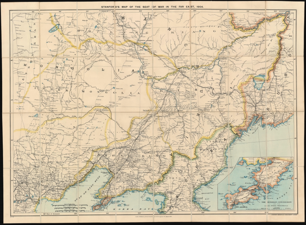
Stanford's Map of the Seat of War in the Far East, 1904.
1904 (dated) 33.5 x 45.5 in (85.09 x 115.57 cm) 1 : 1520640
1904 (dated) 33.5 x 45.5 in (85.09 x 115.57 cm) 1 : 1520640
Description
A scarce 1904 map of China, Manchuria, Mongolia, and northern Korea issued by Stanford's Geographical Establishment to illustrate the theater of the Russo-Japanese War (1904 - 1905). Coverage extends from Beijing to Vladivostok, and from the Amur River to Port Arthur (Lüshunkou), making this one of the most highly detailed and masterful executed contemporaneous maps to illustrate the war.
There was initially some attempt at negotiation between the imperialist powers, but Tsar Nicholas II arrogantly believed it impossible that Japan could challenge a major European power. Japan proved him wrong, launching a surprise attack on the Russian Eastern Fleet stationed at Port Arthur. Throughout the course of the war, the Russians were defeated again and again, humiliating the Tsar and forcing U.S. President Theodore Roosevelt to arbitrate a peace, confirmed by the Treaty of Portsmouth. The treaty recognized Japan's claims on Korea and called for the evacuation of Russian forces from Manchuria, including from Port Arthur.
The overwhelming victory of Imperial Japan came as a surprise to international observers, being the first major military victory in the modern era of an Asian over European power. The consequences transformed the balance of power, confirmed Japan as the pre-eminent power in East Asia.
Russo-Japanese War
The Russo-Japanese War, fought from February 8, 1904 - September 5, 1905, pitted Imperial Japan against Tsarist Russia over rival imperial ambitions in Manchuria and Korea. Both Russia and Japan had grand visions for the region. Russia traditionally had only one Pacific port, Vladivostok, which was operational only during the warm summer months. In 1898, Russia coerced China, then weakened after the First Sino-Japanese War (1894 - 1895), to lease Port Arthur, a warm water port on the Liaodang Peninsula. They also negotiated a right-of-way to connect Port Arthur to the China Eastern Railway, which ran from nearby Dalian (Dalny) to Harbin, a stop on the Siberian Railway. Russia, eager to expand southwards from Siberia, considered Port Arthur the cornerstone of a sphere of influence covering China, Manchuria, and Korea. Japan had its own Imperial ambitions and saw itself as the natural overlord in East Asia. Korea and Manchuria in particular were important as steppingstones into China, with its seemly unlimited resources.There was initially some attempt at negotiation between the imperialist powers, but Tsar Nicholas II arrogantly believed it impossible that Japan could challenge a major European power. Japan proved him wrong, launching a surprise attack on the Russian Eastern Fleet stationed at Port Arthur. Throughout the course of the war, the Russians were defeated again and again, humiliating the Tsar and forcing U.S. President Theodore Roosevelt to arbitrate a peace, confirmed by the Treaty of Portsmouth. The treaty recognized Japan's claims on Korea and called for the evacuation of Russian forces from Manchuria, including from Port Arthur.
The overwhelming victory of Imperial Japan came as a surprise to international observers, being the first major military victory in the modern era of an Asian over European power. The consequences transformed the balance of power, confirmed Japan as the pre-eminent power in East Asia.
Publication History and Census
This present map, a first edition, was published in London by Edward Stanford's Geographical Establishment on March 14, 1904. A second state was issued a in the following year on June 27, 1905. Examples are scarce on the market and in institutional collections, but we have identified holdings at the British Library (St. Pancras), the Library of Congress, the Peabody Essex Museum, the University of Manchester Library, and the National Library of Australia.Cartographer
Edward Stanford (May 27, 1827 - November 3, 1904) was one of the most prolific map publishing firms of the late 19th century. The company began as a partnership in 1848 between the 21 year old Edward Stanford and the established map dealer Trelawney Saunders. By 1853 the partnership had dissolved and Edward Stanford took full control of the business. A subsequent series of expansions and exciting new map issues finally led to the production of Stanford's masterwork, "Stanford's Library Map of London". This map is still available and remains somewhat accurate. At the time of publishing it was hailed by the Royal Geographical Society as "the most perfect map of London that has ever been issued". In 1882 Edward Stanford Sr. passed the firm on to his son, Edward Stanford Jr. who continued in his father's proud tradition. Today the Stanford firm still publishes maps and remains one of the most important and prolific cartographic publishers in the world. More by this mapmaker...
Condition
Very good. Folds into original binder. Linen backing.
References
OCLC 842133170. Library of Congress, G7820 1904 .E3.