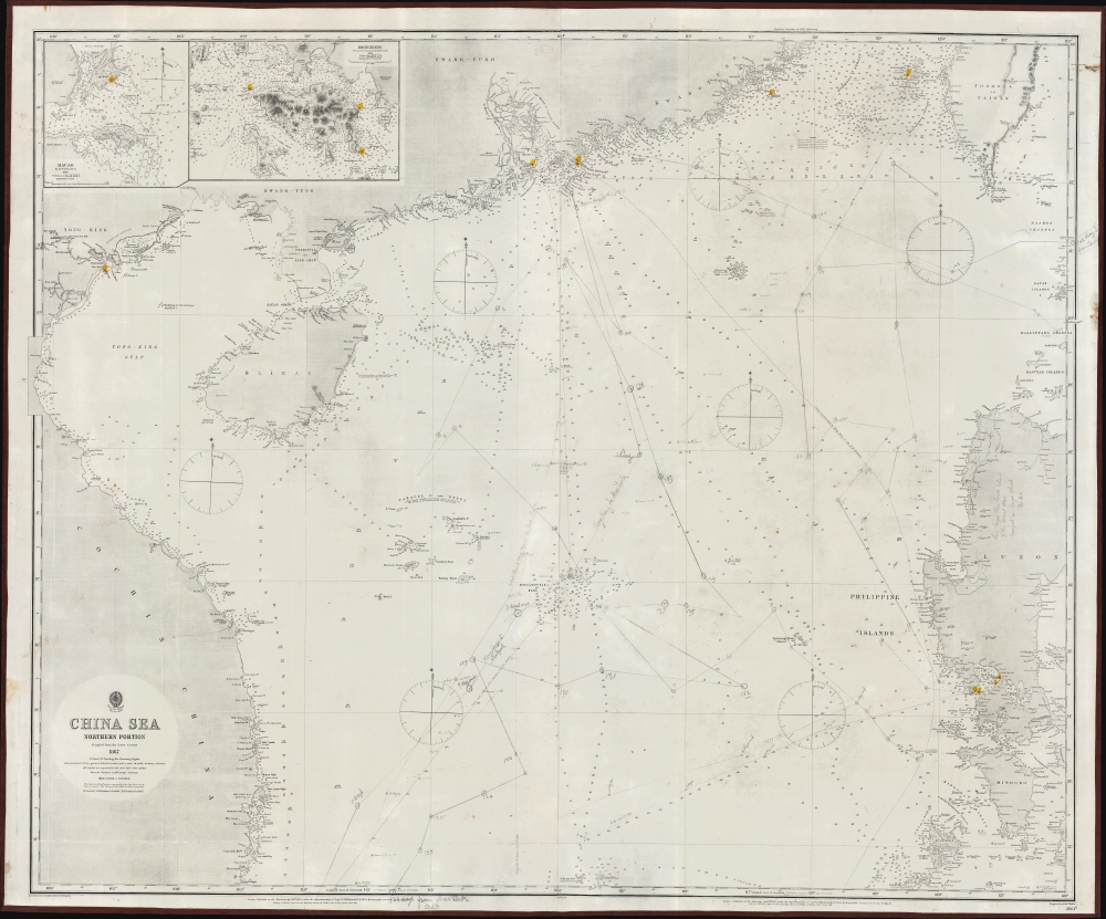
1873 British Admiralty Nautical Map of the South China Sea: Hong Kong, Philippines, Vietnam
ChinaSeaNorth-admiralty-1873$2,700.00


Title
China Sea Northern Portion.
1873 (dated) 39.5 x 48 in (100.33 x 121.92 cm) 1 : 1500000
1873 (dated) 39.5 x 48 in (100.33 x 121.92 cm) 1 : 1500000
Description
This is an exceptional 1867 / 1873 British Admiralty map of the South China Sea, including Hong Kong and the Philippines, representing some of the world's most disputed waters.
There are inset maps detailing Macao (1:64856) and Hong Kong (1:125000). The Macao map is based on the 1866 surveys of W. A. Read. The Hong Kong map follows the 1841 Belcher chart, with updates in sounding and around Hong Kong city (Victoria).
This is a sailed nautical chart with copious pencil annotations reflecting several c. 1890s voyages between New York, Hong Kong, the Philippines, and Cardiff.
A Closer Look
Coverage embraces from the Vietnamese coast and Tong-King Gulf east to the western Philippines, and from the Pearl River Delta, as far as Guangzhou (Canton) and Southern Taiwan, to Mindoro and northern Palawan. The map illustrates some of the world's most trafficked and disputed seas, including primary nautical routes to Hong Kong, Macao, Guangzhou, Taiwan, and Manila.There are inset maps detailing Macao (1:64856) and Hong Kong (1:125000). The Macao map is based on the 1866 surveys of W. A. Read. The Hong Kong map follows the 1841 Belcher chart, with updates in sounding and around Hong Kong city (Victoria).
This is a sailed nautical chart with copious pencil annotations reflecting several c. 1890s voyages between New York, Hong Kong, the Philippines, and Cardiff.
Disputed Seas
This part of the South China Sea is central to geopolitical tension focused on territorial disputes over various atolls, islets, and reefs. Central to these disputes are the Paracel Islands (at center) and the Spratley Islands (south of this map), both of which are subject to overlapping territorial claims by China, Taiwan, Vietnam, the Philippines, Malaysia, and Brunei. These claims are driven by strategic military interests, potential natural resources, and crucial shipping lanes. The situation is further complicated by the construction of artificial islands and military installations, particularly by China. These have led to international condemnation and increased military presence from other nations, including the United States, underscoring the area's status as a flashpoint in regional and global politics.Blueback Charts
Blueback nautical charts began appearing in London in the late 18th century. Bluebacks, as they came to be called, were privately published large-format nautical charts known for their distinctive blue paper backing. The backing, a commonly available blue manila paper traditionally used by publishers to wrap unbound pamphlets, was adopted as a practical way to reinforce the low-quality paper used by private chart publishers to cut costs. That being said, not all blueback charts are literally backed with blue paper, some are unbacked or backed with linen. Moreover, as blueback charts which were typically composed of multiple sheets, they were designed in a modular fashion, so that multiple charts could be joined to create truly massive custom maps suited for specific voyages. The earliest known blueback charts include a 1760 chart issued by Mount and Page, and a 1787 chart issued by Robert Sayer. The tradition took off in the early 19th century, when British publishers like John Hamilton Moore, Robert Blachford, James Imray, William Heather, John William Norie, Charles Wilson, David Steel, R. H. Laurie, and John Hobbs, among others, rose to dominate the chart trade. Bluebacks became so popular that the convention was embraced by chartmakers outside of England, including Americans Edmund March Blunt and George Eldridge, as well as Scandinavian, French, German, Russian, and Spanish chartmakers. Blueback charts remained popular until the late 19th century, when government-subsidized organizations like the British Admiralty Hydrographic Office and the United States Coast Survey, began issuing their own superior charts on high-quality paper that did not require reinforcement.Publication History and Census
This map was first published by the British Admiralty in 1867. It was engraved by the London firm of J. and C. Walker. The present example exhibits updates to about 1873. We see one example in OCLC, but no history of the present full chart on the market.CartographerS
The British Admiralty Office (1795 - Present) or the United Kingdom Hydrographic Office refers to the Branch of the English government that is responsible for the command of the British Navy. In 1795 King George III created the United Kingdom Hydrographic Office, known in short as the U.K.H.O., to provide top notch nautical charts to the vast Royal Navy. Prior the founding of the Admiralty the surveying and creation of nautical charts was primarily a commercial venture wherein the cartographer himself, more of than not, actually financed the printing of his own material. The great navigator Cook himself is known to have scrambled for funds to publish his own seminal charts - the most important and advanced of the period. The system of privately funded nautical mapping and publishing left vast portions of the world uncharted and many excellent charts unpublished. King George III, responding significant loss in trade revenue related to shipwrecks and delay due to poor charts, recognized the need for an institutionalized government sponsored cartographic agency - the Admiralty. The first head of the Admiralty, a position known as Hydrographer, was the important cartographer Alexander Dalrymple. Dalrymple started by organizing and cataloging obtainable charts before initiating the laborious process of updating them and filling in the blanks. The first official Admiralty Chart appeared in 1800 and detailed Quiberon Bay in Brittany. By 1808 the position of Hydrographer fell to Captain Thomas Hurd. Hurd advocated the sale of Admiralty charts to the general public and, by the time he retired in 1829, had issued and published some 736 charts. Stewardship of the organization then passed to Rear Admiral Sir Francis Beaufort. It was under Beaufort's administration that the Admiralty truly developed as a "chart making" as opposed to a "chart cataloging" institution. Beaufort held his post from 1829 to 1854. In his 25 years at the Admiralty Beaufort created nearly 1500 new charts and sponsored countless surveying and scientific expeditions - including the 1831 to 1836 voyage of the H.M.S. Beagle. By 1855 the Admiralty's chart catalog listed some 1,981 charts. More by this mapmaker...
John Walker (1787 - April 19, 1873) was a British map seller, engraver, lithographer, hydrographer, geographer, draughtsman, and publisher active in London during the 19th century. Walker published both nautical charts and geographical maps. His nautical work is particularly distinguished as he was an official hydrographer for the British East India Company, a position, incidentally, also held by his father of the same name. Walker's maps, mostly published after 1827, were primarily produced with his brothers Charles Walker and Alexander Walker under the imprint J. and C. Walker. Among their joint projects are more than 200 maps for the influential Society for the Diffusion of Useful Knowledge Atlas (SDUK). In addition they published numerous charts for James Horsburgh and the British Admiralty Hydrographic Office, including Belcher's important map of Hong Kong and Carless' exploratory map of Karachi. The J. and C. Walker firm continued to publish after both Walkers died in the 1870s. Learn More...
Condition
Very good. Manuscript annotation. Laid on blue linen.
References
OCLC 70895980.