Digital Image: 1877 American Civil War Corps of Engineers Map of Defenses of Cincinnati, Ohio
Cincinnati-engineers-1877_d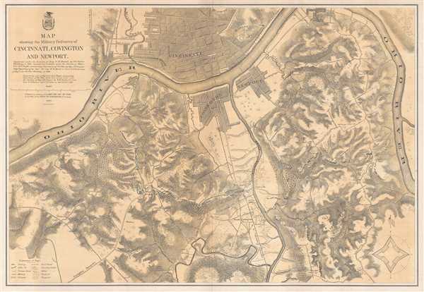

Title
Map showing the Military Defences of Cincinnati, Covington and Newport.
1877 (dated) 25.75 x 37.25 in (65.405 x 94.615 cm) 1 : 16000
1877 (dated) 25.75 x 37.25 in (65.405 x 94.615 cm) 1 : 16000
Description
FOR THE ORIGINAL ANTIQUE MAP, WITH HISTORICAL ANALYSIS, CLICK HERE.
Digital Map Information
Geographicus maintains an archive of high-resolution rare map scans. We scan our maps at 300 DPI or higher, with newer images being 600 DPI, (either TIFF or JPEG, depending on when the scan was done) which is most cases in suitable for enlargement and printing.
Delivery
Once you purchase our digital scan service, you will receive a download link via email - usually within seconds. Digital orders are delivered as ZIP files, an industry standard file compression protocol that any computer should be able to unpack. Some of our files are very large, and can take some time to download. Most files are saved into your computer's 'Downloads' folder. All delivery is electronic. No physical product is shipped.
Credit and Scope of Use
You can use your digial image any way you want! Our digital images are unrestricted by copyright and can be used, modified, and published freely. The textual description that accompanies the original antique map is not included in the sale of digital images and remains protected by copyright. That said, we put significant care and effort into scanning and editing these maps, and we’d appreciate a credit when possible. Should you wish to credit us, please use the following credit line:
Courtesy of Geographicus Rare Antique Maps (https://www.geographicus.com).
How Large Can I Print?
In general, at 300 DPI, you should at least be able to double the size of the actual image, more so with our 600 DPI images. So, if the original was 10 x 12 inches, you can print at 20 x 24 inches, without quality loss. If your display requirements can accommodate some loss in image quality, you can make it even larger. That being said, no quality of scan will allow you to blow up at 10 x 12 inch map to wall size without significant quality loss. For more information, it is best consult a printer or reprographics specialist.
Refunds
If the high resolution image you ordered is unavailable, we will fully refund your purchase. Otherwise, digital images scans are a service, not a tangible product, and cannot be returned or refunded once the download link is used.
Cartographer
Horatio Gouverneur Wright (March 6, 1820 - July 2, 1889) was an engineer and general in the Union Army during the American Civil War. Born in Clinton, Connecticut, in 1834 at the age of fourteen, Wright began attending Alden Partridge's military academy in Vermont (now Norwich University), and three years later entered the United States Military Academy at West Point. After graduating from West Point in 1841 second in his class with a commission in the engineers, he spent the next several years teaching engineering and French at the Academy. He was transferred to Florida in 1846 and spent the next ten years working on the harbor of St. Augustine and the defenses of Key West.At the beginning of the war, Wright participated in the evacuation and destruction of the Gosport Navy Yard (now known as the Norfolk Navy Yard) to prevent the Confederacy from using the facility. Wright saw action at the First Battle of Bull Run and, due to successful raids against military targets along the coast of Florida in 1862, was appointed major general of volunteers and commander of the Department of the Ohio in August of that year. Unfortunately, his promotion was not confirmed by the Senate so he was removed as commander of the Department in March 1863. By May 1863, Wright was in command of the 1st Division of the VI Corps of the Army of the Potomac, with whom he saw combat at Gettysburg, Mine Run, the Battle of the Wilderness, and Spotsylvania Court House, where he assumed command of the Vi Corps following the death of Major General John Sedgwick. Wright and his troops then fought at Cold Harbor and soon after was dispatched to Washington, D.C. to defend against Confederate General Jubal Early's offensive against the city. After the end of the war, Wright commanded the Army of Texas from July 1865 until August 1866. During his post-war career with the engineers, Wright was involved in the construction of the Brooklyn Bridge and the completion of the Washington Monument. Wright was named Chief of Engineers in June 1879 and retired at the rank of brigadier general on March 6, 1884. More by this mapmaker...
References
LOC G4084.C4 1877 .U5. Stephenson, R. W., Civil War Maps; an Annotated List of Maps and Atlases in Map Collections of the Library of Congress, 319. OCLC 47909353.