Digital Image: 1941 Williams Pictorial Map of Cincinnati, Ohio
CincinnatiIn1841-williams-1941_d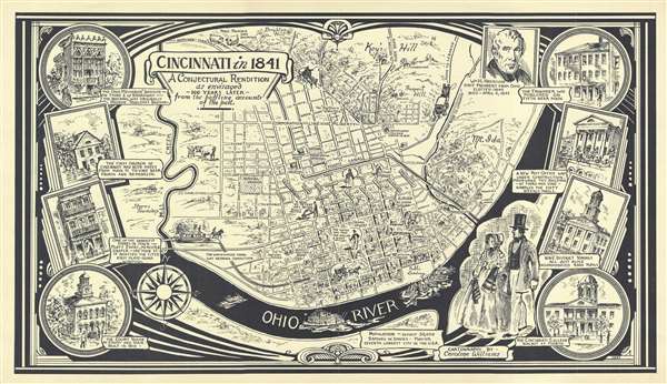

Title
Cincinnati in 1841. A Conjectural Rendition as envisaged 100 years later from the baffling accounts of the past.
1941 (dated) 11 x 19 in (27.94 x 48.26 cm)
1941 (dated) 11 x 19 in (27.94 x 48.26 cm)
Description
FOR THE ORIGINAL ANTIQUE MAP, WITH HISTORICAL ANALYSIS, CLICK HERE.
Digital Map Information
Geographicus maintains an archive of high-resolution rare map scans. We scan our maps at 300 DPI or higher, with newer images being 600 DPI, (either TIFF or JPEG, depending on when the scan was done) which is most cases in suitable for enlargement and printing.
Delivery
Once you purchase our digital scan service, you will receive a download link via email - usually within seconds. Digital orders are delivered as ZIP files, an industry standard file compression protocol that any computer should be able to unpack. Some of our files are very large, and can take some time to download. Most files are saved into your computer's 'Downloads' folder. All delivery is electronic. No physical product is shipped.
Credit and Scope of Use
You can use your digial image any way you want! Our digital images are unrestricted by copyright and can be used, modified, and published freely. The textual description that accompanies the original antique map is not included in the sale of digital images and remains protected by copyright. That said, we put significant care and effort into scanning and editing these maps, and we’d appreciate a credit when possible. Should you wish to credit us, please use the following credit line:
Courtesy of Geographicus Rare Antique Maps (https://www.geographicus.com).
How Large Can I Print?
In general, at 300 DPI, you should at least be able to double the size of the actual image, more so with our 600 DPI images. So, if the original was 10 x 12 inches, you can print at 20 x 24 inches, without quality loss. If your display requirements can accommodate some loss in image quality, you can make it even larger. That being said, no quality of scan will allow you to blow up at 10 x 12 inch map to wall size without significant quality loss. For more information, it is best consult a printer or reprographics specialist.
Refunds
If the high resolution image you ordered is unavailable, we will fully refund your purchase. Otherwise, digital images scans are a service, not a tangible product, and cannot be returned or refunded once the download link is used.
Cartographer
Caroline Williams (November 10, 1908 - 1988) was an artist from Cincinnati, Ohio renowned and celebrated for her ‘A Spot in Cincinnati’ series of sketches, which appeared in the Cincinnati Enquirer from 1932 until 1979. She was recognized for the incredible amount of research she did for each of the captions for her sketches, adding much to local knowledge of Cincinnati. She was born in Covington, Kentucky and grew up in Cincinnati, where her father found a job as a staff artist at the Cincinnati Enquirer. He would rise up through the ranks and eventually become the director of the Art Department of the Enquirer, until he died of pneumonia in 1928. Williams grew up in College Hill, a neighborhood in Cincinnati, and then attended the University of Cincinnati for a year, followed by two year at the Cincinnati Art Academy and another two years at the Art Student’s League in New York. She was hired by the Cincinnati Enquirer as a staff artist in 1932, following in her father’s footsteps. Williams gained notoriety, celebrity even, due to her acclaimed series ‘A Spot in Cincinnati’, which began in November 1932. Cincinnatians would eagerly await their Sunday paper to see what would be the next ‘nook’ featured by Williams in her sketches. Over the course of her career, Williams published several books of her sketches and drawing of Cincinnati, and she left her job at the Enquirer in 1945 to become a free-lance artist. From 1945 until her death in 1988, Williams self-published and printed a series of books and prints, having converted the hen house behind her cabin into her own printing studio. Williams is still fondly remembered in the Cincinnati area, and her works remain popular to this day. More by this mapmaker...