1705 Nicholas de Fer Map of Cologne, Germany
Cologne-nicholasdefer-1705$300.00

Title
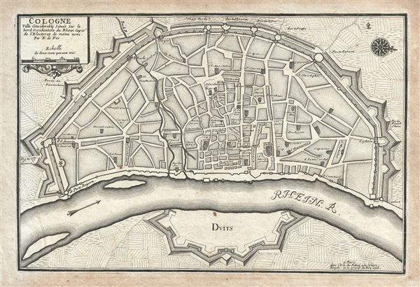
Cologne Ville Considerable Situee Sur le bord Occidentale du Rhein Capit. de l'Electorat de meme nom.
1705 (dated) 9.5 x 14 in (24.13 x 35.56 cm) 1 : 11000
1705 (dated) 9.5 x 14 in (24.13 x 35.56 cm) 1 : 11000
Description
This is a beautiful 1705 Nicholas de Fer map of the walled city of Cologne, Germany. Oriented with North to the right, this map identifies the location of the city on the banks of the Rhine River. Originally the capital city of the Roman province Germania Inferior, Cologne was established in 50 AD. The medieval city wall surrounding the city was built in 1180 and enclosed the Free Imperial City for 600 years. Of the original 12 city gates, only Eigelsteintorburg, Hahnentorburg, Severinstorburg and Ulrepforte remain to this day. The remains of Bayen, the medieval tower and the city wall at Gereonswall can also been seen today.
This map identifies various streets, churches and other notes other topographical details throughout. This map created by Nicholas de Fer in 1705.
This map identifies various streets, churches and other notes other topographical details throughout. This map created by Nicholas de Fer in 1705.
Nicholas de Fer (1646 - October 25, 1720) was a French cartographer and publisher, the son of cartographer Antoine de Fer. He apprenticed with the Paris engraver Louis Spirinx, producing his first map, of the Canal du Midi, at 23. When his father died in June of 1673 he took over the family engraving business and established himself on Quai de L'Horloge, Paris, as an engraver, cartographer, and map publisher. De Fer was a prolific cartographer with over 600 maps and atlases to his credit. De Fer's work, though replete with geographical errors, earned a large following because of its considerable decorative appeal. In the late 17th century, De Fer's fame culminated in his appointment as Geographe de le Dauphin, a position that offered him unprecedented access to the most up to date cartographic information. This was a partner position to another simultaneously held by the more scientific geographer Guillaume De L'Isle, Premier Geograph de Roi. Despite very different cartographic approaches, De L'Isle and De Fer seem to have stepped carefully around one another and were rarely publicly at odds. Upon his death of old age in 1720, Nicolas was succeeded by two of his sons-in-law, who also happened to be brothers, Guillaume Danet (who had married his daughter Marguerite-Geneviève De Fer), and Jacques-François Bénard (Besnard) Danet (husband of Marie-Anne De Fer), and their heirs, who continued to publish under the De Fer imprint until about 1760. It is of note that part of the De Fer legacy also passed to the engraver Remi Rircher, who married De Fer's third daughter, but Richer had little interest in the business and sold his share to the Danet brothers in 1721. Learn More...
Condition
Very good. Original platemark visible. Blank on verso. Minor overall toning.