Digital Image: 1902 Nell's Map of Colorado
Colorado-nell-1902_d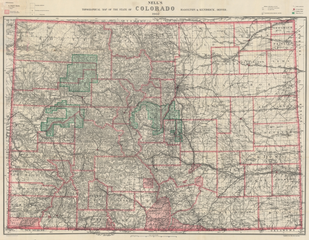


Title
Nell's Topographical Map of the State of Colorado.
1902 (dated) 31.25 x 40.24 in (79.375 x 102.2096 cm) 1 : 633600
1902 (dated) 31.25 x 40.24 in (79.375 x 102.2096 cm) 1 : 633600
Description
FOR THE ORIGINAL ANTIQUE MAP, WITH HISTORICAL ANALYSIS, CLICK HERE.
Digital Map Information
Geographicus maintains an archive of high-resolution rare map scans. We scan our maps at 300 DPI or higher, with newer images being 600 DPI, (either TIFF or JPEG, depending on when the scan was done) which is most cases in suitable for enlargement and printing.
Delivery
Once you purchase our digital scan service, you will receive a download link via email - usually within seconds. Digital orders are delivered as ZIP files, an industry standard file compression protocol that any computer should be able to unpack. Some of our files are very large, and can take some time to download. Most files are saved into your computer's 'Downloads' folder. All delivery is electronic. No physical product is shipped.
Credit and Scope of Use
You can use your digial image any way you want! Our digital images are unrestricted by copyright and can be used, modified, and published freely. The textual description that accompanies the original antique map is not included in the sale of digital images and remains protected by copyright. That said, we put significant care and effort into scanning and editing these maps, and we’d appreciate a credit when possible. Should you wish to credit us, please use the following credit line:
Courtesy of Geographicus Rare Antique Maps (https://www.geographicus.com).
How Large Can I Print?
In general, at 300 DPI, you should at least be able to double the size of the actual image, more so with our 600 DPI images. So, if the original was 10 x 12 inches, you can print at 20 x 24 inches, without quality loss. If your display requirements can accommodate some loss in image quality, you can make it even larger. That being said, no quality of scan will allow you to blow up at 10 x 12 inch map to wall size without significant quality loss. For more information, it is best consult a printer or reprographics specialist.
Refunds
If the high resolution image you ordered is unavailable, we will fully refund your purchase. Otherwise, digital images scans are a service, not a tangible product, and cannot be returned or refunded once the download link is used.
Cartographer S
Louis Max Nell (January 3, 1842 - January 2, 1908) was a German-American surveyor, explorer, publisher, and map maker. Nell was born in Altenkirchen, Germany and studied in Civil Engineering in Coblentz and Berlin. He emigrated to the United States, arriving in New York in 1865. He issues several maps, including maps of New York, New England, and California. He moved to Washington, D.C. in 1870 to work as a civilian contractor for the Corps of Topographical Engineers. He was sent to Colorado as a topographer with Captain George Wheeler's survey expedition from 1871 - 1879. Impressed with Colorado, Nell left the Corps of Topographical Engineers to settle in Denver. Shortly thereafter, he leveraged the wealth of information collected during the Wheeler survey to compile and issue highly detailed and influential commercial maps of the state. His work eclipsed that of his predecessor in Colorado mapping, H. L. Thayer in scope, detail, and regularity of updates. Nell issued 2 map series focused on Colorado entire: The medium format Topographical and Township Map of Colorado, which was issued from about 1880 to 1906; and the large format, Topographical Map of the State of Colorado, issued from 1886 to 1907. In addition to his work in Colorado, he was a member of the Norther Transcontinental Survey from 1882 - 1883. He was also sent to Alabama to complete surveys in 1888 - 1889 under Major Powell. He continued to work as a draftsman at the U.S. Geological Survey office in Colorado until 1907. He died one year later in 1908. More by this mapmaker...
Hamilton and Kendrick (1891 - 1903) was a Denver, Colorado based publishing firm active in the late 19th and early 20th centuries. The firm was founded by Charles Almond Kendrick and William F. Hamilton. Kendrick (October 17, 1862 - September 16, 1946) was born in Randolph, Ohio, but moved to Colorado with his family in 1875. Kendrick got involved in ranching and developed significant holdings just west of Denver. In 1891, he provided financing for William F. Hamilton (1860 - April 16, 1900) to establish a printing and publishing concern, 'Hamilton and Kendrick'. When Hamilton died 9 years later, Kendrick gave up ranching and moved to Denver to take over management. In 1903 it was renamed Kendrick Book and Stationery Company, and again in 1909 as Kendrick-Bellamy Company, reflecting a new partner, Harry Elbert Bellamy. In cartographic circles the firm of Hamilton and Kendrick is best known as the publisher of Louis Nell's (1842 - 1908) Topographical Map of the State of Colorado, issued from 1886 to 1907. Learn More...
Isaac Friedenwald (July 25, 1831 - March 25, 1904) was a German-Jewish-American Baltimore based lithographer and printer active in the late 18th and early 19th centuries. Friedenwald was born in Hesse, Germany, but emigrated to the United States with is parents in 1831, when he was 2 months old. During the American Civil War (1861 - 1865), Friedenwald fought for the Confederate cause. In 1875, Louis E. E Levy, also an Orthodox Jew, patented the Levytype Process, a photo-lithographic technique. Along with Levy and William Deutsch, Friedenwald founded the Levytype Photo-Engraving Company, based at 103 W. Fayette Street. The company's name was almost immediately changed to 'Isaac Friedenwald Company', perhaps suggesting some internal conflict. Levy left the firm in 1877, taking his equipment with him. Friedenwald nonetheless persevered, purchasing new presses ande adjacent business, including a bindery. In 1893 a new entity is formed, the Friedenwald Company, which then fully acquired 'Isaac Friedenwald Company'. In 1906, well after Friedenwald's death, the firm was taken over by Nathan Billstein (18?? - 1931) and Simon Dalsheimer (1858 - 1948), who renamed it Lord Baltimore Press. In 1970, Lord Baltimore Press was absorbed by International Paper. Learn More...
References
OCLC 7223824.