1966 Civic Education Service Pictorial Map of Communist China
CommunistChina-civiceducation-1966$400.00

Title
Communist China. Headline-Focus Wall Map 15.
1966 (dated) 27.25 x 36.25 in (69.215 x 92.075 cm) 1 : 7120000
1966 (dated) 27.25 x 36.25 in (69.215 x 92.075 cm) 1 : 7120000
Description
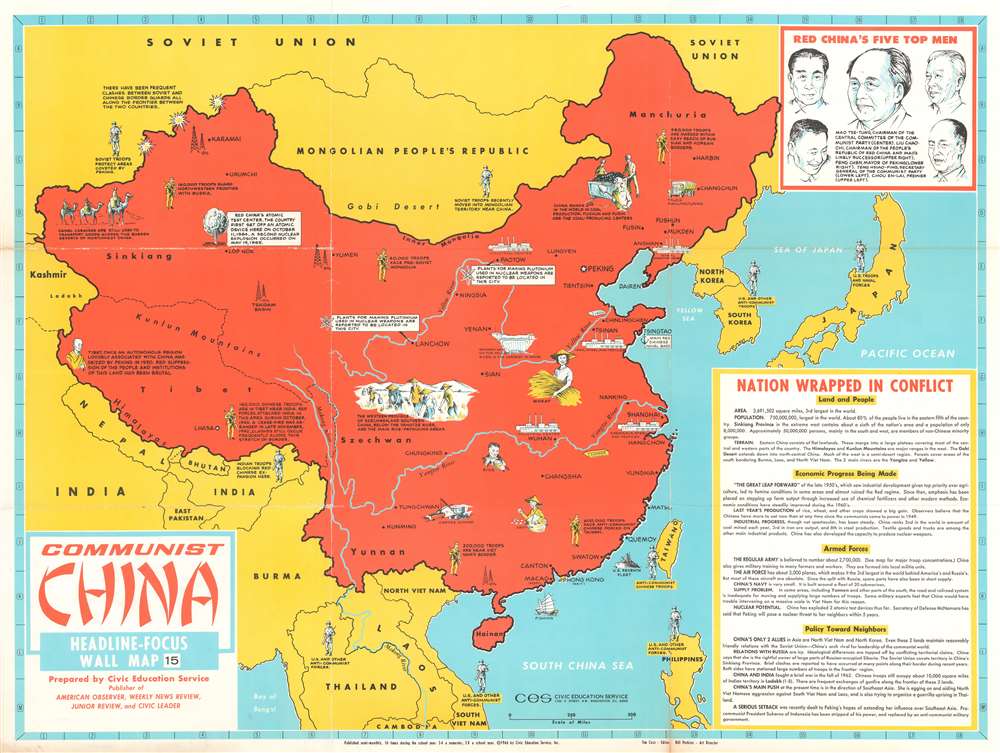
This is a 1966 Civic Education Service pictorial map of China, more specifically 'Communist China'. Created just before U.S.-China relations began thawing in the 1970s, the entirety of China is shaded red, the color most associated with Communism. Pictorial vignettes highlight Chinese industry, with particular interest paid to mining and manufacturing. Chinese progress in the realm of nuclear weapons is also prominently noted. An illustration of an atom marks industrial plants suspected of making the plutonium necessary in the development of these weapons, and a mushroom cloud, the most infamous image associated with nuclear weapons, marks the nuclear test site near Lop Nor. Icons of soldiers, situated throughout China and all of the surrounding countries, reinforce the tense military situation in the region. Short texts also explain that Soviet and Chinese forces had clashed along the border separating the two countries, as have Chinese and Indian troops along their mutual border. 'U.S. and other anti-Communist forces', essential to the American policy of 'containment' are stationed in Thailand, South Vietnam, Taiwan, the Philippines, South Korea, and Japan. A text box entitled 'Nation Wrapped in Conflict' provides details for the viewer about the population and geography of China, as well as the economic, military, and diplomatic situation in China.
Publication History and Census
This map was created and published by the Civic Education Service in 1966. The OCLC records examples of this map as being part of the institutional collection at Cornell University. An example is also part of the David Rumsey Map Collection.Cartographer
The Civic Education Service (fl. c. 1939 - 1945, 1963 - 1972) was a publishing firm based in Washington, D.C. that produced maps and other visual material for academic purposes. Our research has led us to believe that an organization known as the Civic Education Service existed from c. 1939 - c. 1945 (during World War II) and from c. 1963 - c. 1972. We have been unable to determine if this is the same organization that was closed for almost twenty years, or if the organization that published maps and other educational materials in the 1960s and 1970s was unrelated to the Civic Education Service that published books, maps, and other materials during World War II. More by this mapmaker...
Condition
Good. Exhibits wear and slight loss along original fold lines and at some fold intersections. Closed margin tears professionally repaired on verso. Verso repairs to fold separations. Blank on verso.
References
Rumsey 9521.000. OCLC 64055886.