
Civic Education Service

The Civic Education Service (fl. c. 1939 - 1945, 1963 - 1972) was a publishing firm based in Washington, D.C. that produced maps and other visual material for academic purposes. Our research has led us to believe that an organization known as the Civic Education Service existed from c. 1939 - c. 1945 (during World War II) and from c. 1963 - c. 1972. We have been unable to determine if this is the same organization that was closed for almost twenty years, or if the organization that published maps and other educational materials in the 1960s and 1970s was unrelated to the Civic Education Service that published books, maps, and other materials during World War II.
Pacific supply lines.
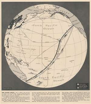
The Pacific Ocean.
$275.00
Acquire
- Digital Map Information
- Suitable for large format printing
- File Size: 20.83 MB
- File Type: ZIP / TIFF
- ICC color profile embedded
- Delivered instantly via download link
This is a 1943 Kermit Johnson and Civic Education Service map of the Pacific during World War II. The map's main focus is the vast distances involved in fighting a war across the Pacific. It illuminates in a simple, straightforward way the challenge of transporting troops and supplies from the United States to Australia, where American supplies were staged. The text along bottom border puts this in perspective, 'In area it [the Pacific] is greater than all the land surface of the world. In width - 10,000 miles at the equator - it makes the Atlantic seems small by comparison.' Johnson uses silhouettes of cargo ships and planes to differentiate between routes (although they are illustrated here as being practically identical). (more details)
Communists and Capitalists during the Vietnam War.
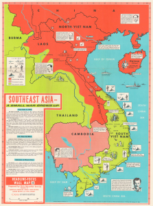
This is a 1965 Civil Education Service pictorial map of Southeast Asia highlighting regional social and political divisions during the Vietnam War. (more details)
Presents Communist China to 1960s American schoolchildren.
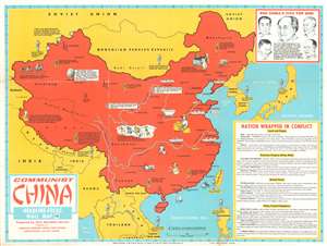
Communist China. Headline-Focus Wall Map 15.
$400.00
Acquire
- Digital Map Information
- Suitable for large format printing
- File Size: 46.8 MB
- File Type: ZIP / TIFF
- ICC color profile embedded
- Delivered instantly via download link
This is a 1966 Civic Education Service pictorial map of China, more specifically 'Communist China'. Created just before U.S.-China relations began thawing in the 1970s, the entirety of China is shaded red, the color most associated with Communism. Pictorial vignettes highlight Chinese industry, with particular interest paid to mining and manufacturing. Chinese progress in the realm of nuclear weapons is also prominently noted. An illustration of an atom marks industrial plants suspected of making the plutonium necessary in the development of these weapons, and a mushroom cloud, the most infamous image associated with nuclear weapons, marks the nuclear test site near Lop Nor. Icons of soldiers, situated throughout China and all of the surrounding countries, reinforce the tense military situation in the region. Short texts also explain that Soviet and Chinese forces had clashed along the border separating the two countries, as have Chinese and Indian troops along their mutual border. 'U.S. and other anti-Communist forces', essential to the American policy of 'containment' are stationed in Thailand, South Vietnam, Taiwan, the Philippines, South Korea, and Japan. A text box entitled 'Nation Wrapped in Conflict' provides details for the viewer about the population and geography of China, as well as the economic, military, and diplomatic situation in China. (more details)
Pictorial map highlighting important events in global exploration.
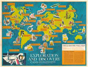
This is a 1966 Civic Education Service pictorial map of the world highlighting historical exploration and discovery. Nearly three dozen historical events are described on banners across the world. These include Leif Ericson's landing at 'Vinland', Hudson's exploration of Hudson Bay, Magellan's circumnavigation of the Earth, Stanley and Livingstone's meeting in Africa, and John Glenn's orbit of the Earth in Friendship 7. Pictorial vignettes illustrate each event, with portraits of Roald Amundsen, Hernando Cortez, and Amerigo Vespucci, among them. An illustration of space exploration appears in the lower left corner, illustrating the next frontier of human exploration. Only three years later Armstrong and Aldrin walked on the Moon. Unfortunately, their prediction that humanity would explore the planets and other galaxies has not come to fruition. (more details)
Created to celebrate the 100th anniversary of the purchase of Alaska by the United States.
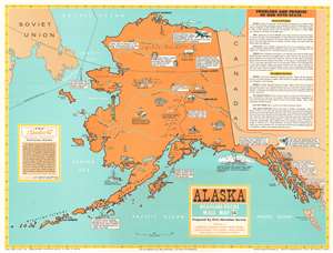
This is a 1967 Civic Education Service pictorial wall map of Alaska celebrating the centennial of the purchase of Alaska. Pictorial vignettes dot the state and highlight the state's industry, people, and wildlife. Fishing boats promote Alaskan halibut and king crab and a special vignette references the impounding of Soviet fishing trawlers discovered in Alaskan waters. Several fish canneries are illustrated, along with mines for gold, tin, and beryllium, and successful trappers. North of the Arctic Circle, Eskimos and Indians are stated to be the only people in residence, with vignettes of caribou, grizzly bears, and a dogsled team alongside them. Alaska's remoteness is also emphasized, aside from the barrenness of the land above the Arctic Circle. The map states that only 550 miles of railroad track has been built in the state, which is the largest in the U.S. Cities and towns are labeled, including Juneau, the state capital, Fairbanks, Seward, Anchorage, and Dutch Harbor. Several rivers are illustrated and labeled, and Mt. McKinley, the tallest mountain in the U.S., is featured in a vignette, as is the Brooks Range above the Arctic Circle. A textbox in the lower left celebrates the 100th anniversary of 'Seward's Folly', better known as the purchase of Alaska from Russia by the United States, while a second, larger textbox summarizes Alaska's people, land, and industries. (more details)
An educational pictorial map of Brazil.
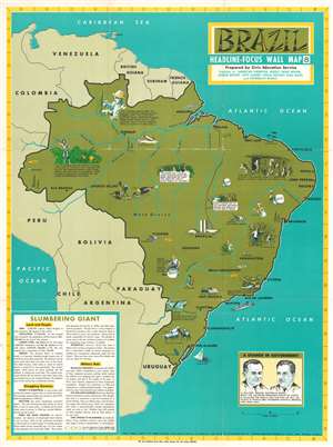
Brazil. Headline Focus Wall Map 8.
$300.00
Acquire
- Digital Map Information
- Suitable for large format printing
- File Size: 80.81 MB
- File Type: ZIP / TIFF
- ICC color profile embedded
- Delivered instantly via download link
This is a 1967 Civic Education Service pictorial map of Brazil. Created only three years after a military coup d'état seized power, the map highlights Brazilian economic hardships as well as exports. Vignettes illustrate the extreme differences between life in the urban slums (called favelas in Brazil) and the uncontacted tribes that live in the Amazon. Brazil's abundant resources, including timber, coffee, copper, manganese, iron, and other ores are promoted, while rubber, which was once Brazil's largest export, had become one of its least exported goods, after the seeds of rubber trees were smuggled out of the country and planted abroad. Iguazu Falls, the largest waterfall in the world, is illustrated in the extreme southern portion of Brazil near Argentina and Paraguay. Perhaps the most intriguing reference to a modern audience, however, is the 'march to the west' in the Amazon, where workers were clearing jungle so it could be replaced by grazing and farmland. This phenomenon still continues today and is of major concern with regard to the current global climate crisis. Another shocking reference, made in the last sentence of the text, is the concern that, if the Brazilian military hadn't seized power, that the country may have turned toward Communism. This fear led to the American government supporting the coup and the authoritarian military regime that took power. (more details)
War of Attrition.
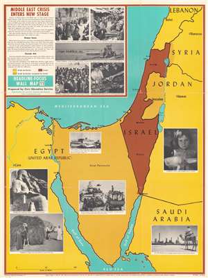
This is a 1969 Civic Education Service map of the Middle East focusing on Israel, the Sinai Peninsula, and the surrounding region. Published during the War of Attrition between Israel and Egypt, Israel is shaded brown, and the surrounding Arab states (Lebanon, Syria, Jordan, Saudi Arabia, and Egypt) yellow. Brown and yellow parallel lines illustrate areas occupied by Israel, including the Sinai, Gaza, the West Bank, and the Golan Heights. Since this piece was created for use in schools, photographs present the conflict and the countries involved, including Egyptian and Jordanian refugees and cultural sites in Israel and Egypt. (more details)
Features an artistic rendering of several submersible vehicles - including the Aluminaut, the world's first aluminum submarine.
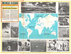
World Ocean.
$400.00
Acquire
- Digital Map Information
- Suitable for large format printing
- File Size: 73.35 MB
- File Type: ZIP / TIFF
- ICC color profile embedded
- Delivered instantly via download link
This is a 1970 Civic Education Service broadside map of the world's oceans. The world map situated at center labels Earth's four major oceans (the Arctic, Atlantic, Indian, and Pacific) and provides the area of each in square miles and each ocean's deepest point. Visually captivating content frames the central map, with photographs of ocean waves, researchers aboard the 'Alvin', and a porpoise delivering a message from a submersible off the California coast. Other photographs present a desalinization plant at Guantanamo Bay, Cuba, an island being formed in Indonesia, and oceanography students conducting field research. (more details)
Celebrates Japan's phoenix-like rise after the devastation of World War II.
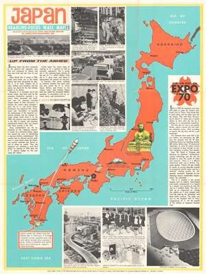
This is a 1970 Civic Education Service wall map of Japan celebrating that nation's meteoric recovery after World War II and the recently-opened Expo '70 world's fair outside Osaka. Japan's home islands, colored orange, are flanked by two blocks of text. The text block on the left applauds Japanese economic successes and their sensational rise 'up from the ashes' of World War II. When this map was printed, Japan had recently passed West Germany to become the world's third-strongest economic power. The photographs printed along the right reinforce Japan's economic power and highlight its auto industry, dressmaking schools, and its shipyards. Japan's generosity toward 'underdeveloped nations' is also promoted. The successful launch of a satellite into space, illustrated here by a rocket 'painted with red and white stripes like a barber's pole,' gained Japan entry into the exclusive 'Space Club' alongside the U.S., the Soviet Union, France, and Britain. (more details)