1870 Vallardi Map of Umbria - Lazio or the Country Around Rome, Italy
CompagnaRoma-vallardi-1870$450.00
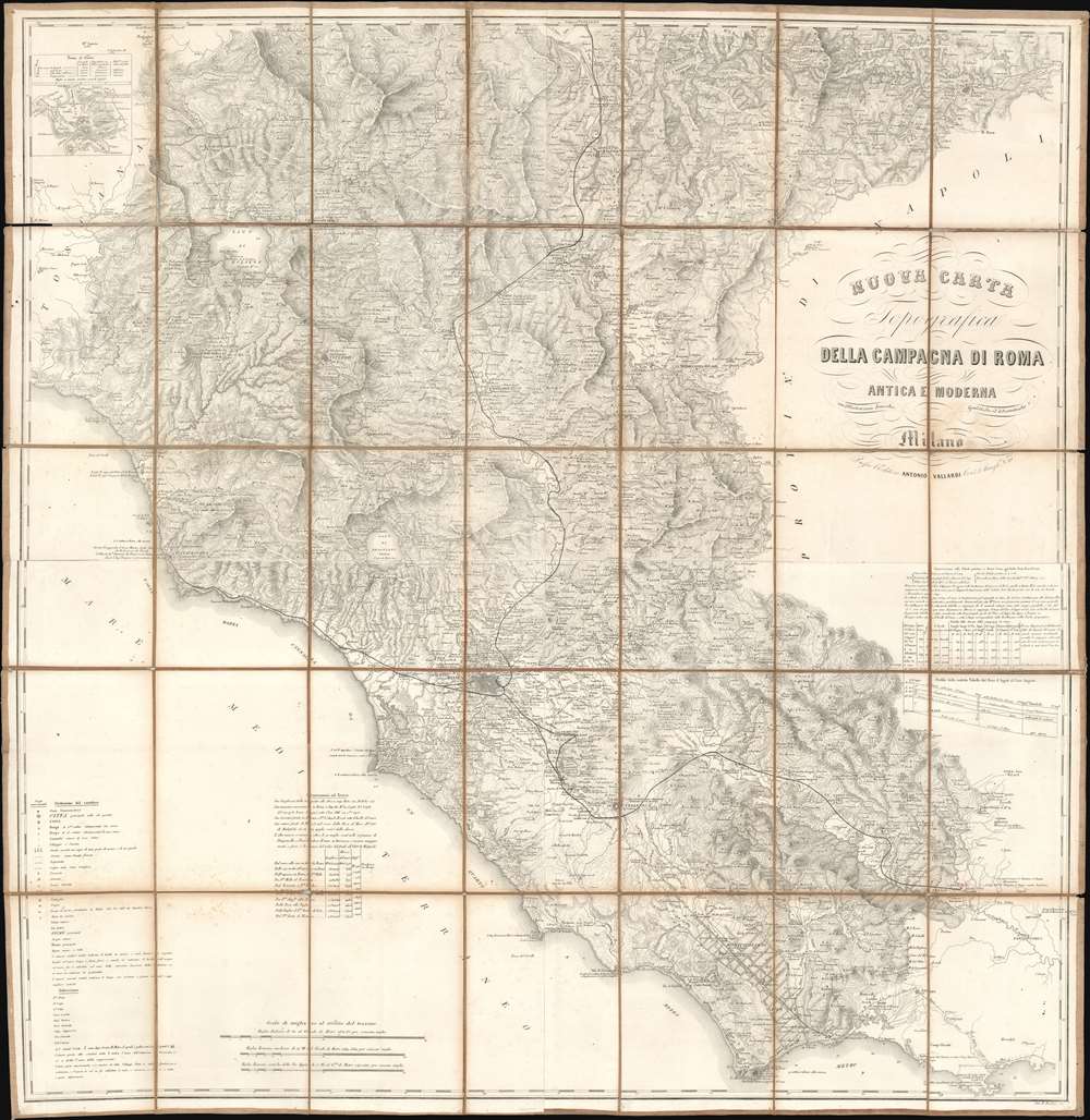

Title
Nuova Carta Topografica della Campagna di Roma Antica e Moderna.
1870 (undated) 39.75 x 38.75 in (100.965 x 98.425 cm) 1 : 200000
1870 (undated) 39.75 x 38.75 in (100.965 x 98.425 cm) 1 : 200000
Description
Published c. 1870, this Antonio Vallardi and Giovanni Battista Bordiga map of Lazio and Umbria details the vestiges of independent Italian city-states during Italian unification. Led by Giuseppe Maria Garibaldi (1807 -1882), wars had raged across Italy that slowly brought the peninsula's various states together under one crown. Victor Emmanuel II of Sardinia became the sovereign of the Kingdom of Italy in 1861. But the last independent state, held by the Pope, stubbornly held out until 1870, when it fell flowing a siege.
The Map's Details
Rome lies below center to the left, and myriad other cities, towns, and villages appear throughout the region. A note references the French army's 1849 landing at Civitavecchia, and a dotted line traces Trajan's aqueduct from that city back to Rome. Crosses mark bishoprics. Crossed swords mark battles throughout the centuries, including some from the Wars of Italian Independence. Dates mark important events both before Christ (A.C. - Avanti Christo) and after (A - anno dopo Cristo). A key situated on the lower left helps elucidate the many notations Vallardi and Bordiga used.Publication History and Census
This map was engraved by Giovanni Battista Bordiga and published by Antonio Vallardi c. 1870. Vallardi published editions of this map beginning as early as 1840 and into the 1880s. Examples of various editions are cataloged in OCLC and appear on the market from time to time.CartographerS
Antonio Vallardi (1813 - 1876) was an Italian publisher and founder of the Antonio Vallardi publishing house. Born into a Milanese publishing family, his grandfather Cesare Vallardi (1736 - 1799) began publishing books in Contrada Santa Margherita in the 1750s. Vallardi's father, Pietro (1770 - 1819), and uncle Giuseppe (1784 - 1861) continued their father's publishing business but renamed the company Fratelli Vallardi and became prominent publishers of books and art prints. Pietro's sons, Franceso and Antonio, both founded their own publishing houses. Antonio Vallardi opened his publishing house in 1843, three years after his brother. Antonio's publishing house became known for academic and linguistic works, alongside the many maps and guides it published for the Touring Club. Antonio's descendants operated the publishing house until 1970, when they sold the firm to Garzanti. More by this mapmaker...
Giovanni Battista Bordiga (1799 - 18xx) was an Italian engraver who produced dozens of works, many of which were maps. Learn More...
Condition
Good. Dissected and mounted on old linen in 35 panels. Exhibits some toning. Linen reinforced in places on verso.