Digital Image: 1895 Promotional Map of Compton Heights, St. Louis, Missouri
ComptonHeights-buxtonskinner-1895_d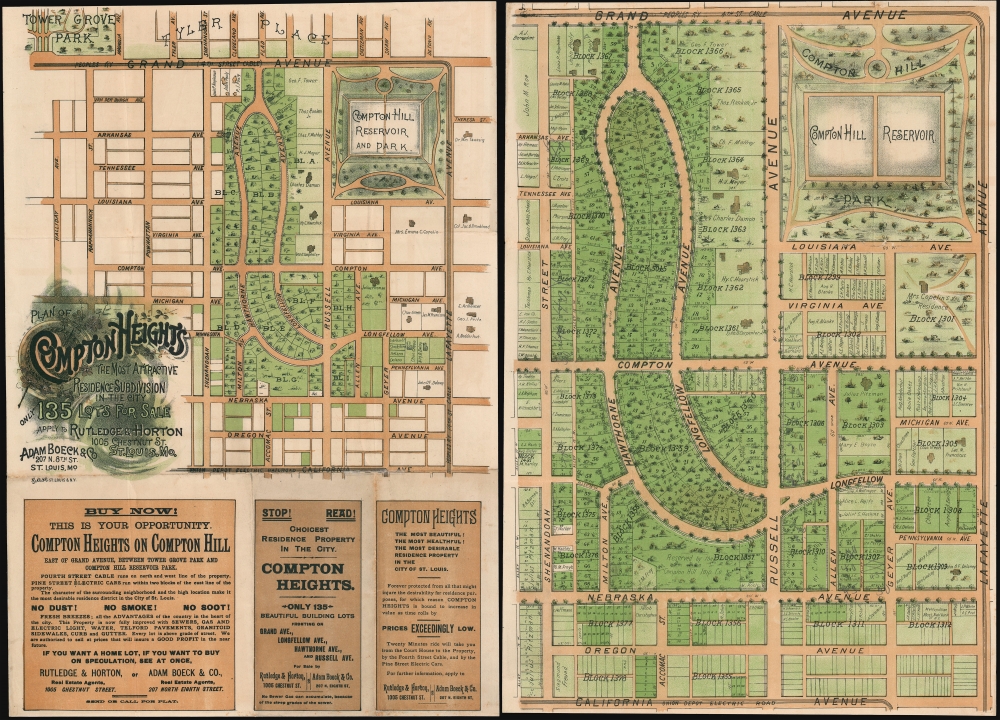

Title
Plan of Compton Heights The Most Attractive Residence Subdivision in the City.
1895 (undated) 20.5 x 14.25 in (52.07 x 36.195 cm)
1895 (undated) 20.5 x 14.25 in (52.07 x 36.195 cm)
Description
FOR THE ORIGINAL ANTIQUE MAP, WITH HISTORICAL ANALYSIS, CLICK HERE.
Digital Map Information
Geographicus maintains an archive of high-resolution rare map scans. We scan our maps at 300 DPI or higher, with newer images being 600 DPI, (either TIFF or JPEG, depending on when the scan was done) which is most cases in suitable for enlargement and printing.
Delivery
Once you purchase our digital scan service, you will receive a download link via email - usually within seconds. Digital orders are delivered as ZIP files, an industry standard file compression protocol that any computer should be able to unpack. Some of our files are very large, and can take some time to download. Most files are saved into your computer's 'Downloads' folder. All delivery is electronic. No physical product is shipped.
Credit and Scope of Use
You can use your digial image any way you want! Our digital images are unrestricted by copyright and can be used, modified, and published freely. The textual description that accompanies the original antique map is not included in the sale of digital images and remains protected by copyright. That said, we put significant care and effort into scanning and editing these maps, and we’d appreciate a credit when possible. Should you wish to credit us, please use the following credit line:
Courtesy of Geographicus Rare Antique Maps (https://www.geographicus.com).
How Large Can I Print?
In general, at 300 DPI, you should at least be able to double the size of the actual image, more so with our 600 DPI images. So, if the original was 10 x 12 inches, you can print at 20 x 24 inches, without quality loss. If your display requirements can accommodate some loss in image quality, you can make it even larger. That being said, no quality of scan will allow you to blow up at 10 x 12 inch map to wall size without significant quality loss. For more information, it is best consult a printer or reprographics specialist.
Refunds
If the high resolution image you ordered is unavailable, we will fully refund your purchase. Otherwise, digital images scans are a service, not a tangible product, and cannot be returned or refunded once the download link is used.
Cartographer
Buxton and Skinner (1878 - 1999) were stationers and lithographer active in Saint Louis in the late 19th and early 20th centuries. The firm was founded by Charles Mather Skinner (November 3, 1847 - January 13, 1929) and Oliver W. Buxton (1835 - 18??). Little is known of Oliver Buxton save that he was a clerk at R. P. Studley and company as early as 1866. Skinner was born in New York and first became involved in the printing business in 1865 in Chicago. He relocated to St. Louis in 1869, taking work with the firm of R. P. Studley and Company. Studley and Company closed its doors in 1878 and their business was taken over by staffers Buxton and Skinner, who renamed after themselves. The firm served initially as a stationer with just two small water driven presses. Their offices were initially located at 219 and 221 Chestnut Street, St. Louis. These offices burnt to the ground in December of 1880, causing considerable loss, and forcing them to relocate to new offices at 215 Chestnuts Street, at the same time they formally incorporated. Buxton retired in 1886, at which point his shares were acquired by Charles Skinner, but the name, Buxton and Skinner, remained. In 1898 they added a new printing facility at 306-308 North Fourth Street. By this time, it had become one of the largest printing concerns in the United States. The firm continued to prosper through multiple generations of the Skinner family. In 1999 Buxton and Skinner was acquired by the conglomerate Mail-Well. More by this mapmaker...