This item has been sold, but you can get on the Waitlist to be notified if another example becomes available, or purchase a digital scan.
1933 Kaiser Persuasive Pictorial Map of the United States
ConquestContinent-kaiser-1933$300.00

Title
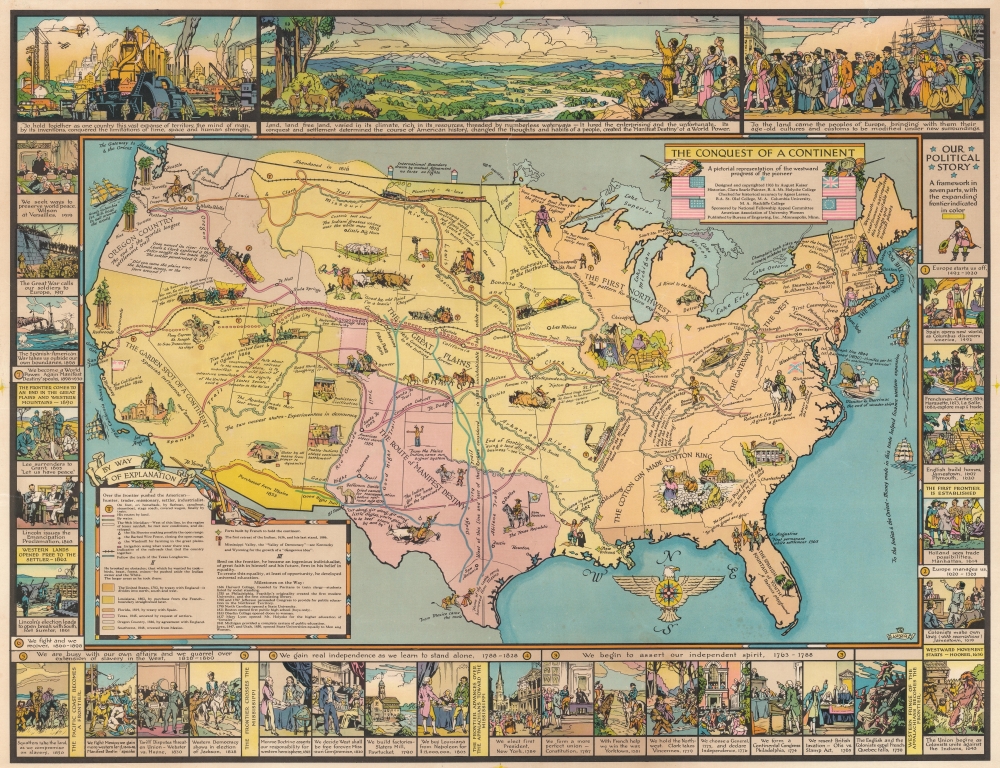
The Conquest of a Continent. A pictorial representation of the westward progress of the pioneer.
1933 (dated) 21 x 27.25 in (53.34 x 69.215 cm)
1933 (dated) 21 x 27.25 in (53.34 x 69.215 cm)
Description
This is a 1933 August Kaiser persuasive pictorial map of the United States. While the map chronicles American expansion across the continent, it also proclaims American Exceptionalism and the rise of the United States to global power. Pictorial vignettes and tidbits of American history populate the map, many of which make broad historical proclamations. Historical firsts (first newspaper, first steamboat, etc.) are lauded alongside achievements such as the National Road and Transcontinental Railroad. Color highlights the territorial expansion of the U.S. from 1783 through the 1803 Louisiana Purchase, to the 1846 annexation of Texas, and the 1848 Mexican Cession. A pictorial border creates a decidedly exceptional version of the history of the United States and features illustrations from Columbus 'discovering' the New World to President Wilson at the 1919 Paris Peace Conference.
Manifest Destiny - American Expansion Across North America
Manifest Destiny, the cultural belief that American settlers were destined to spread across the North American continent, first appeared in 1839 as a 'divine destiny' referred to by journalist John L. O'Sullivan. The phrase 'Manifest Destiny' first appeared in 1845 and advocated for U.S. annexation of the Republic of Texas, stating that it was 'our manifest destiny to overspread the continent allotted by Providence for the free development of our yearly multiplying millions'. The phrase gained popularity through opposition, when Whigs denounced it as advocating for the 'right of conquest'. While expansionists (of which there were many in 19th century America) heartily supported this belief, other prominent figures opposed it. Among them was Ulysses S. Grant, who fought in the Mexican-American War (and later became the commander of the Union Army during the American Civil War and the 18th President of the United States). He wroteI was bitterly opposed to the measure [to annex Texas], and to this day regard the war [with Mexico] which resulted as one of the most unjust ever waged by a stronger against a weaker nation. It was an instance of a republic following the bad example of European monarchies, in not considering justice in their desire to acquire additional territory'.
Publication History and Census
This map was designed and copyrighted by August Kaiser in 1933 from material compiled by Clara Searle Painter for the American Association of University Women and published by the Bureau of Engraving, Inc. in Minneapolis, Minnesota. We note ten examples cataloged in OCLC: Osher Map Library at the University of Southern Maine, the Newberry Library, the University of Wisconsin - Milwaukee, the Wisconsin Historical Society, the University of Minnesota, Minnesota State University Mankato, the Denver Public Library, the University of Washington, and the State Library of Oregon. It is rare on the private market, with only a handful of records appearing in the last few years.Cartographer
August Kaiser (October 2, 1889 - September 7, 1982) was an artist, illustrator, and engraver. Born in Krumbach, Bavaria, Germany, Kaiser studied art in Germany before he immigrated to the United States in 1907. He was living in Minneapolis, Minnesota by 1910, when he was also a naturalized citizen. Kaiser developed a lucrative career as a commercial artist as well as a painter. He designed numerous State Fair posters during the 1920s and designed the Reddy Kilowatt character used in electricity advertisements. Kaiser attended art school in New York in the 1920s and studied in Europe in 1955. He lived in Minneapolis for most of his life and retired to Santa Fe, New Mexico, in 1970. At the time of his retirement Kaiser was one of the best known artists in the Minneapolis region. He continued to paint and create art while living in New Mexico. He married Marguerite Boye on August 12, 1939, with whom he had two sons. More by this mapmaker...
Condition
Average. Backed on archival tissue for stability. Top right corner reinstated. Closed tears extending eight-and-one-half (8.5) and six (6) inches respectively through center portion of image.
References
OCLC 9724264.