This item has been sold, but you can get on the Waitlist to be notified if another example becomes available, or purchase a digital scan.
1749 Vaugondy Map of Morocco, Western Sahara, and Mauritania
CoteOccidAfrique-vaugondy-1749$75.00

Title
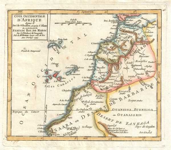
Cote Occidentale d'Afrique depuis le Detroit de Gibraltar jusqu'au C. Blanc où se trouvent les Etats du Roi de Maroc. Par le Sr. Robert de Vaugondy Fils de Mr. Robert Geogr. ord. du Roi.
1749 (dated) 6.5 x 7.75 in (16.51 x 19.685 cm) 1 : 12000000
1749 (dated) 6.5 x 7.75 in (16.51 x 19.685 cm) 1 : 12000000
Description
This is a hand colored 1749 Didier Robert de Vaugondy map of northwestern Africa, depicting from the Canary Islands to Algeria and from southern Spain and the Strait of Gibraltar to Western Sahara and Mauritania. The map centers on Morocco, which is divided into four distinct regions, the States of the King of Morocco (Etats du Roi de Maroc). The first, the Kingdom of Fez (Royaume de Fez), was established in the 8th century and existed until the establishment of the French and Spanish protectorate in 1912. The Kingdom of Fez included both Fez and Tangiers. The Kingdom of Morocco is also labeled, while the other two states are not. The Atlas Mountains divide the three states along the coast, the Kingdom of Fez, the Kingdom of Morocco, and a third, unlabeled, state, from the fouth, which parallels the mountains and is depicted as equivalent in size to the other three combined. Outside of Morocco, the regions are collectively labeled as the Sahara, or Desert of Barbary (Saara ou Desert de Barbarie). Several different tribes of 'Arabs' are labeled in these areas. Off the coast of Africa, the seven Canary Islands are depicted, Tenerife, Fuerteventura, Gran Canaria, Lanzarote, La Palma, La Gomera, and El Hierro (I. de Fer). The 'First Meridian' runs through El Hierro and was fixed there by a decree of French King Louis XIII in 1634. The islands of Madeira and Porto Santo are depicted above the Canary Islands. The southern tip of Spain is also included and Cadiz, Malaga, and Gibraltar are labeled. Rivers are depicted throughout the map and towns dot the landscape in the States of the King of Morocco.
This map was published by Gilles Robert de Vaugondy in his Atlas Universel, Portatif et Militaire in the 1749 edition.
This map was published by Gilles Robert de Vaugondy in his Atlas Universel, Portatif et Militaire in the 1749 edition.
Cartographer
Robert de Vaugondy (fl. c. 1716 - 1786) was French may publishing from run by brothers Gilles (1688 - 1766) and Didier (c. 1723 - 1786) Robert de Vaugondy. They were map publishers, engravers, and cartographers active in Paris during the mid-18th century. The father and son team were the inheritors to the important Nicolas Sanson (1600 - 1667) cartographic firm whose stock supplied much of their initial material. Graduating from Sanson's maps, Gilles, and more particularly Didier, began to produce their own substantial corpus. The Vaugondys were well-respected for the detail and accuracy of their maps, for which they capitalized on the resources of 18th-century Paris to compile the most accurate and fantasy-free maps possible. The Vaugondys compiled each map based on their own geographic knowledge, scholarly research, journals of contemporary explorers and missionaries, and direct astronomical observation. Moreover, unlike many cartographers of this period, they took pains to reference their sources. Nevertheless, even in 18th-century Paris, geographical knowledge was limited - especially regarding those unexplored portions of the world, including the poles, the Pacific Northwest of America, and the interiors of Africa, Australia, and South America. In these areas, the Vaugondys, like their rivals De L'Isle and Buache, must be considered speculative or positivist geographers. Speculative geography was a genre of mapmaking that evolved in Europe, particularly Paris, in the middle to late 18th century. Cartographers in this genre would fill in unknown lands with theories based on their knowledge of cartography, personal geographical theories, and often dubious primary source material gathered by explorers. This approach, which attempted to use the known to validate the unknown, naturally engendered rivalries. Vaugondy's feuds with other cartographers, most specifically Phillipe Buache, resulted in numerous conflicting papers presented before the Academie des Sciences, of which both were members. The era of speculative cartography effectively ended with the late 18th-century explorations of Captain Cook, Jean Francois de Galaup de La Perouse, and George Vancouver. After Didier died, his maps were acquired by Jean-Baptiste Fortin, who in 1787 sold them to Charles-François Delamarche (1740 - 1817). While Delamarche prospered from the Vaugondy maps, he defrauded Vaugondy's window Marie Louise Rosalie Dangy of her rightful inheritance and may even have killed her. More by this mapmaker...
Source
Robert de Vaugondy, G., Atlas Portatif, Universel, et Militaire, (Paris: Vaugondy, Durand, Pissot) 1749.
Condition
Very good. Blank on verso. Original press mark visible.
References
Pedley, M. S., Bel et Utile, p. 206, 434. OCLC 159769980.