1957 U.S. Coast Survey Aeronautical Chart of Dallas, Texas and Environs
DallasAeronauticalChart-uscs-1957$450.00


Title
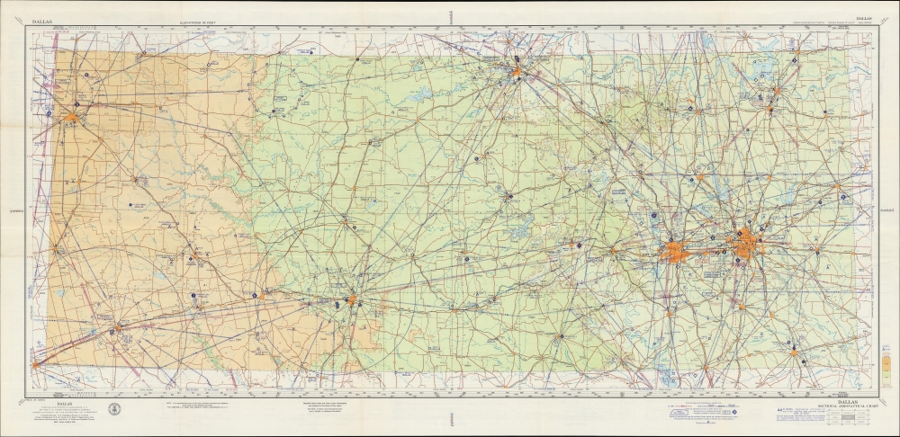
Dallas Sectional Aeronautical Chart. 43rd Edition. U. S. Air Force Edition.
1957 (dated) 23 x 48.5 in (58.42 x 123.19 cm) 1 : 500000
1957 (dated) 23 x 48.5 in (58.42 x 123.19 cm) 1 : 500000
Description
A large-format aeronautical chart of northern Texas, focusing on the Dallas-Fort Worth region, prepared in 1957 by the U.S. Coast and Geodetic Survey. The map records Dallas' pioneering contributions to early American aviation.
A Closer Look
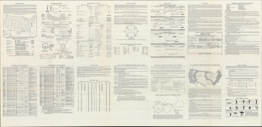
The chart covers a wide portion of northern Texas, from Lubbock and Midland to Dallas and Fort Worth. Civilian and military airports are labeled throughout, connected by flightpaths shaded purple (civilian) or red (military). The verso includes legends explaining aeronautical and topographical symbols used throughout the chart, a full list of aerodromes included on the recto, an index map of the sectional aeronautical charts covering the entire U.S., prohibited and restricted areas, a map of the U.S. with Air Defense Identification Zones indicated information on radio frequencies, emergency signals, cruising altitudes, and more.Dallas and the Early Days of Aviation
Dallas and the surrounding area have played an important role in the history of aviation. Braniff International Airways, founded in Dallas in 1928, was one of the earliest major commercial airlines operating international routes (to Mexico, the Caribbean, and Central and South America). Dallas also became a hub for aviation manufacturing, including North American Aviation (later North American Rockwell, then Rockwell International, which was later acquired by Boeing), which was headquartered in Dallas and played a crucial role in producing aircraft for the United States during World War II. Dallas Love Field, established in 1917, served as a military training base during World War I and later became a commercial airport. It played a significant role in the development of the American aviation industry and continues to be an important airport in the region. Finally, the development of Dallas-Fort Worth Airport (discussed below) and the growth of Southwest Airlines have made the region into one of the centers for commercial aviation in the United States and globally in recent decades.The Days before DFW
This chart predates the construction of Dallas-Fort Worth Airport. While the concept of a unified airport for the cities had existed for some time, the cities and surrounding communities could not agree on a site, so each maintained its own airport, Love Field in Dallas and Meacham Field in Fort Worth, as well as nearby Amon Carter Field. But by the time of this map's production, these airports were sorely inadequate to meet the area's commercial aviation needs. After long discussion, votes, and considerable pressure from the Federal Aviation Administration, a site was finally chosen near Grapevine, and the new airport opened in 1973, ultimately developing into one of the busiest airports in the world.Publication History and Census
This chart was prepared by the U.S. Coast and Geodetic Survey in 1957. It is the 44th edition of the U.S.C.S. Dallas Sectional Aeronautical Chart, which was frequently updated to reflect the addition of new airfields (including military ones) and other changes, which were common in these years. The present edition is not independently cataloged in the OCLC.Cartographer
The Office of the Coast Survey (1807 - present) founded in 1807 by President Thomas Jefferson and Secretary of Commerce Albert Gallatin, is the oldest scientific organization in the U.S. Federal Government. Jefferson created the "Survey of the Coast," as it was then called, in response to a need for accurate navigational charts of the new nation's coasts and harbors. The spirit of the Coast Survey was defined by its first two superintendents. The first superintendent of the Coast Survey was Swiss immigrant and West Point mathematics professor Ferdinand Hassler. Under the direction of Hassler, from 1816 to 1843, the ideological and scientific foundations for the Coast Survey were established. These included using the most advanced techniques and most sophisticated equipment as well as an unstinting attention to detail. Hassler devised a labor intensive triangulation system whereby the entire coast was divided into a series of enormous triangles. These were in turn subdivided into smaller triangulation units that were then individually surveyed. Employing this exacting technique on such a massive scale had never before been attempted. Consequently, Hassler and the Coast Survey under him developed a reputation for uncompromising dedication to the principles of accuracy and excellence. Unfortunately, despite being a masterful surveyor, Hassler was abrasive and politically unpopular, twice losing congressional funding for the Coast Survey. Nonetheless, Hassler led the Coast Survey until his death in 1843, at which time Alexander Dallas Bache, a great-grandson of Benjamin Franklin, took the helm. Bache was fully dedicated to the principles established by Hassler, but proved more politically astute and successfully lobbied Congress to liberally fund the endeavor. Under the leadership of A. D. Bache, the Coast Survey completed its most important work. Moreover, during his long tenure with the Coast Survey, from 1843 to 1865, Bache was a steadfast advocate of American science and navigation and in fact founded the American Academy of Sciences. Bache was succeeded by Benjamin Pierce who ran the Survey from 1867 to 1874. Pierce was in turn succeeded by Carlile Pollock Patterson who was Superintendent from 1874 to 1881. In 1878, under Patterson's superintendence, the U.S. Coast Survey was reorganized as the U.S. Coast and Geodetic Survey (C & GS) to accommodate topographic as well as nautical surveys. Today the Coast Survey is part of the National Oceanic and Atmospheric Administration or NOAA as the National Geodetic Survey. More by this mapmaker...
Condition
Very good. Light wear along original folds. Text on verso.