1972 / 1977 U.S. Geological Survey Topographic Map of Death Valley National Park
DeathValley-usgs-1972$150.00

Title
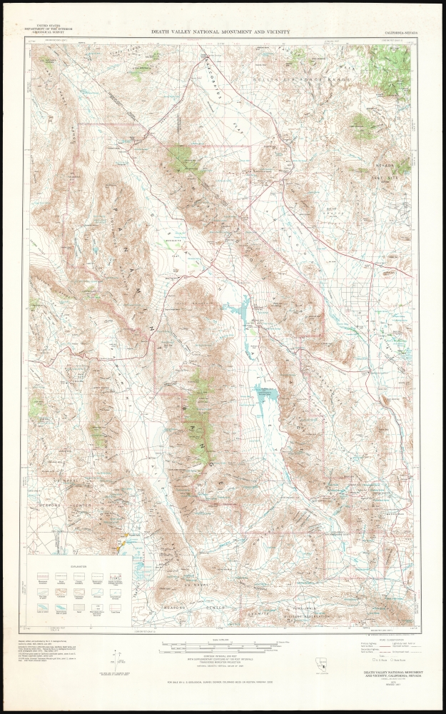
Death Valley National Monument and vicinity, California-Nevada.
1972 (dated) 36 x 12.75 in (91.44 x 32.385 cm) 1 : 62500
1972 (dated) 36 x 12.75 in (91.44 x 32.385 cm) 1 : 62500
Description
This is a 1972/1977 U.S. Geological Survey topographic map of Death Valley National Monument, at the border of California and Nevada. Depicting from Scottys Junction and the Nellis Air Force Range in the north to the Fort Irwin Military reservation in the south, contour lines present the region's forbidding topography in striking detail.
A Closer Look
Mountains throughout are identified and their elevations given. The regions scant, intermittent lakes and streams and rivers are indicated, including Badwater Basin, the lowest elevation in the United States. Towns and villages are labeled as well and dashed lines illustrate county and reservation borders, and the boundary of the National Monument are prominently indicated. Settlements along the few roads spanning the monument are marked along with wells, and hotels along the routes. Roads include CA SR 190, formerly the Eichbaum Toll Road - the first established road to cross Death Valley. In the area surrounding the park are many mines - borate, lead, gold, silver, copper, and lead have all been extracted here. Many features have colorful names, such as the 'Devil's Golf Course,' which is not a golf course at all, but a desolate field of jagged little hills made of salt that have been eroded over centuries to look like a landscape from an alien world.Death Valley National Park
On February 11, 1933, President Herbert Hoover created a nearly two-million-acre national monument in Death Valley. The Civilian Conservation Corps was responsible for the earliest improvements to the park, grading 500 miles of roads, installing telegraph and water lines, and constructing seventy-six buildings. Designated a biosphere reserve in 1994, Death Valley National Monument was expanded by 1.3 million acres on October 31, 1994, and redesignated as Death Valley National Park - the largest national park in the contiguous United States.Publication History and Census
This map was published in 1978 by the U.S. Geological Survey; it was surveyed in 1972, and revised in 1977. The map is well represented in institutional collections.Cartographer
The United States Geological Survey (1878 - Present), aka the U.S.G.S., is a scientific agency of the United States government, which was founded in 1879. USGS scientists study the landscape of the United States, its natural resources, and the natural hazards that threaten it. The organization has four major science disciplines: biology, geography, geology, and hydrology. It is a bureau of the United States Department of the Interior and is the department's only scientific agency. More by this mapmaker...
Condition
Very good. Some light foxing.
References
OCLC 41264024.