Digital Image: 1934 Shepler Map of Dedham, Needham, Norfolk, and Dover, Massachusetts, and Environs
DedhamWestwood-shepler-1934_d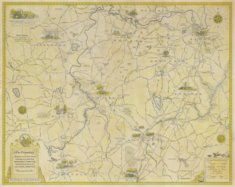

Title
The Townships of Dedham, Westwood, Needham, Dover, Sherborn, Norwood, Medfield, Millis, Walpole, Norfolk, Massachusetts.
1934 (dated) 22 x 27.625 in (55.88 x 70.1675 cm) 1 : 35000
1934 (dated) 22 x 27.625 in (55.88 x 70.1675 cm) 1 : 35000
Description
FOR THE ORIGINAL ANTIQUE MAP, WITH HISTORICAL ANALYSIS, CLICK HERE.
Digital Map Information
Geographicus maintains an archive of high-resolution rare map scans. We scan our maps at 300 DPI or higher, with newer images being 600 DPI, (either TIFF or JPEG, depending on when the scan was done) which is most cases in suitable for enlargement and printing.
Delivery
Once you purchase our digital scan service, you will receive a download link via email - usually within seconds. Digital orders are delivered as ZIP files, an industry standard file compression protocol that any computer should be able to unpack. Some of our files are very large, and can take some time to download. Most files are saved into your computer's 'Downloads' folder. All delivery is electronic. No physical product is shipped.
Credit and Scope of Use
You can use your digial image any way you want! Our digital images are unrestricted by copyright and can be used, modified, and published freely. The textual description that accompanies the original antique map is not included in the sale of digital images and remains protected by copyright. That said, we put significant care and effort into scanning and editing these maps, and we’d appreciate a credit when possible. Should you wish to credit us, please use the following credit line:
Courtesy of Geographicus Rare Antique Maps (https://www.geographicus.com).
How Large Can I Print?
In general, at 300 DPI, you should at least be able to double the size of the actual image, more so with our 600 DPI images. So, if the original was 10 x 12 inches, you can print at 20 x 24 inches, without quality loss. If your display requirements can accommodate some loss in image quality, you can make it even larger. That being said, no quality of scan will allow you to blow up at 10 x 12 inch map to wall size without significant quality loss. For more information, it is best consult a printer or reprographics specialist.
Refunds
If the high resolution image you ordered is unavailable, we will fully refund your purchase. Otherwise, digital images scans are a service, not a tangible product, and cannot be returned or refunded once the download link is used.
Cartographer
Dwight Clark Shepler (August 11, 1905 - September 2, 1974) was an American painter and naval officer who served as an artist during World War II. Born in Everett, Massachusetts, Shepler studied art at Williams College and graduated in 1928. He also took classes at the Boston Museum School of Fine Art. He was a member of the American Artists Professional League and the American Artists' Group. He volunteered for the U.S. Navy in 1942 and, once the Navy was made aware of his education and talent as an artist, assigned him to the newly-created unit of 'officer-artists' as a lieutenant junior grade. He was 36 and had a successful career as an artist in Boston. Shepler saw action in the South Pacific aboard the USS San Juan, on Guadalcanal with the Marines, and aboard the USS Emmons off the coast of Normandy on D-Day. He also saw action in the Philippines. After V-J Day, he was informed that the Navy planned to demobilize him, but he requested an extension so he could finish the paintings he had planned. He completed over 300 paintings during his time in the Navy. He ended up staying in the Navy until 1947 because he was commissioned to complete two murals at the United States Naval Academy. He retired with the rank of Commander and was awarded the Bronze Star for his work. After his time in the service, Shepler continued to work as an artist. He worked as the artist for several mapping expeditions to Mt. Kennedy and Mt. McKinley. He also painted landscapes, sports scenes, and portraits. He died in Weston, Massachusetts. More by this mapmaker...
References
Boston Public Library, Leventhal Map Center G3763.N6 1934 .S54. OCLC 317741999.