Digital Image: 1907 E. M. Beeler Wall Map of Denver, Colorado w/ railroad manuscript
DenverColorado-beeler-1907_d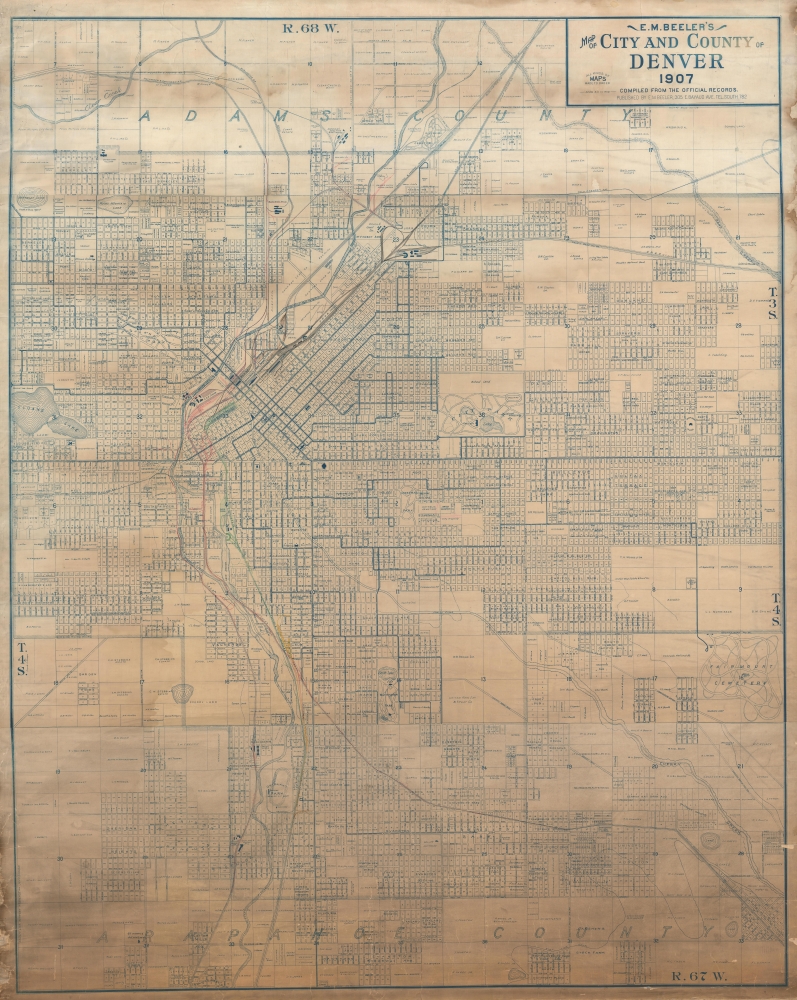

Title
E. M. Beeler's Map of City and County of Denver 1907.
1907 (dated) 71 x 56.5 in (180.34 x 143.51 cm) 1 : 10500
1907 (dated) 71 x 56.5 in (180.34 x 143.51 cm) 1 : 10500
Description
FOR THE ORIGINAL ANTIQUE MAP, WITH HISTORICAL ANALYSIS, CLICK HERE.
Digital Map Information
Geographicus maintains an archive of high-resolution rare map scans. We scan our maps at 300 DPI or higher, with newer images being 600 DPI, (either TIFF or JPEG, depending on when the scan was done) which is most cases in suitable for enlargement and printing.
Delivery
Once you purchase our digital scan service, you will receive a download link via email - usually within seconds. Digital orders are delivered as ZIP files, an industry standard file compression protocol that any computer should be able to unpack. Some of our files are very large, and can take some time to download. Most files are saved into your computer's 'Downloads' folder. All delivery is electronic. No physical product is shipped.
Credit and Scope of Use
You can use your digial image any way you want! Our digital images are unrestricted by copyright and can be used, modified, and published freely. The textual description that accompanies the original antique map is not included in the sale of digital images and remains protected by copyright. That said, we put significant care and effort into scanning and editing these maps, and we’d appreciate a credit when possible. Should you wish to credit us, please use the following credit line:
Courtesy of Geographicus Rare Antique Maps (https://www.geographicus.com).
How Large Can I Print?
In general, at 300 DPI, you should at least be able to double the size of the actual image, more so with our 600 DPI images. So, if the original was 10 x 12 inches, you can print at 20 x 24 inches, without quality loss. If your display requirements can accommodate some loss in image quality, you can make it even larger. That being said, no quality of scan will allow you to blow up at 10 x 12 inch map to wall size without significant quality loss. For more information, it is best consult a printer or reprographics specialist.
Refunds
If the high resolution image you ordered is unavailable, we will fully refund your purchase. Otherwise, digital images scans are a service, not a tangible product, and cannot be returned or refunded once the download link is used.
Cartographer
Edwin Mead Beeler (July 2, 1871 - October 18, 1931) was an American mapmaker, surveyor, businessman, and civil engineer active in Denver, Colorado and New York City, in the early late 19th and 20th centuries. Beeler was born in Cincinnati, Ohio. As a young man he worked as a driver in Cincinnati before taking a clerkship at the Cincinnati offices of the Northern Assurance Company. He remained in this position until about 1895, when he became a 'manufacturing agent.' In search of a better life in the west, he relocated to Denver, Colorado in 1896 or 1897, where he appears in the City Directory as a draughtsman and civil engineer in the employ of the city's Board of Public Works. Given his later career and the content on some of his maps, we suspect Beeler was working on the Denver's tramways. Beeler's earliest maps appear around 1904, all of which focus on Denver. In a rare map, surviving in a single known example, from 1907, he advertises that he makes 'All Kinds of Maps to Order', from his offices at 305 E. Bayaud St. Some are clearly private enterprise, as they contain advertising, others are official-looking maps. He formally established the 'Beeler Map Company' in 1913, when he copyrighted his Official Map of the City and County of Denver, a large format wall map of Denver issued in whiteprint or reverse cyanotype, possibly issued with the support of Denver mapmaker George Clason. Sometime between 1921 and 1930 he relocated to New York City, presumably to retire, but in the 1930s census he is still listed as a 'Street Car Engineer.' Beeler died in 1931 and is buried in Scarsdale, Westchester, New York. More by this mapmaker...
References
OCLC 1008963719.