1854 Pharoah Map of the Chingleput District, Tamil Nadu, India
DistrictChingleput-pharoah-1854$250.00

Title
District of Chingleput.
1854 (undated) 10.5 x 8.5 in (26.67 x 21.59 cm) 1 : 1013760
1854 (undated) 10.5 x 8.5 in (26.67 x 21.59 cm) 1 : 1013760
Description
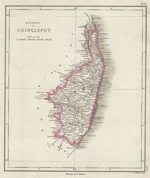
This is an interesting 1854 map of the District of Chingleput in the modern day state of Tamil Nadu, India, issued by Pharoah and Company. It depicts the district from the Pulicat Lake south to Marcanum (Marakkannam) near Pondicheri (Puducherry). Includes Madras (Chennai), Chingleput (Chengalpattu) and other important towns and cities. The map also notes important roads, lakes, rivers and topography. At the time this map was made, India was under British rule and the Chingleput district was part of the Madras Presidency. After India gained independence in 1947, it would become part of Madras State, which would later be named Tamil Nadu. This map was engraved by J. and C. Walker and issued as plate no. 9 by Pharoah and Company in their 1854 Atlas of Southern India.
CartographerS
J. B. Pharoah (fl. c. 1838 – 1869) was a Madras, India, based bookseller and publisher of educational books and maps active in the middle of the 19th century. He maintained a bookshop on Mount Road. The form of which was a general emporium for European published work. They also published a weekly English language newspaper called The Athenaeum and Statesman (in 1864 renamed, The Athenaeum and Daily News). They also published the The Madras Quarterly Medical Journal and The Madras Journal of Literature and Science. More by this mapmaker...
John Walker (1787 - April 19, 1873) was a British map seller, engraver, lithographer, hydrographer, geographer, draughtsman, and publisher active in London during the 19th century. Walker published both nautical charts and geographical maps. His nautical work is particularly distinguished as he was an official hydrographer for the British East India Company, a position, incidentally, also held by his father of the same name. Walker's maps, mostly published after 1827, were primarily produced with his brothers Charles Walker and Alexander Walker under the imprint J. and C. Walker. Among their joint projects are more than 200 maps for the influential Society for the Diffusion of Useful Knowledge Atlas (SDUK). In addition they published numerous charts for James Horsburgh and the British Admiralty Hydrographic Office, including Belcher's important map of Hong Kong and Carless' exploratory map of Karachi. The J. and C. Walker firm continued to publish after both Walkers died in the 1870s. Learn More...
Source
Pharoah and Company, An Atlas of the Southern Part of India including Plans of all the Principal Towns and Cantonments, reduced from the Grand Trigonometrical Survey of India shewing also The Tenasserim Provinces, (Madras) 1854.
The Pharoah and Company Atlas of Southern India was published around 1854. The medium format 4to atlas contained some 70 maps focusing on the southern part of Indian and the Tanasserium Province, or Burma. The atlas was engraved an printed in London by J. and C. Walker, but seems to have been issued only in Madras, India, by J. B. Pharoah and Company. The atlas claims to have been "reduced from the Grand Trigonometrical Survey of India," and, in fact the survey did provide a framework for the atlas, but little of the actual cartographic detail. The atlas is rather novel in that it has universal scale of 16 miles to the inch (1 : 1013760) for most of its regional maps. In addition to its regional maps, the atlas also contained 21city plans. These plans are some of the only obtainable mid-195h century maps of many South Indian cities. It also contained a rare map of Singapore.
Condition
Very good. Minor foxing.
References
OCLC: 710811505.