1924 Bain 'E-Z Guide' Map of Oakland and East Bay Cities
EastBay-bain-1924$250.00

Title
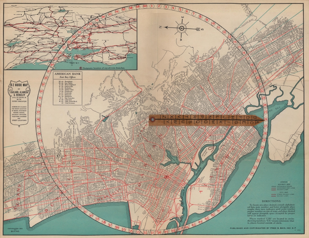
E-Z guide map of Oakland, Alameda and Berkeley, California with patent indicator.
1924 (dated) 13.5 x 17.5 in (34.29 x 44.45 cm) 1 : 42240
1924 (dated) 13.5 x 17.5 in (34.29 x 44.45 cm) 1 : 42240
Description
An example of Fred Bain's 1924 E-Z Guide Map of Oakland, Alameda, Berkeley, and nearby cities in the East Bay portion of the San Francisco Bay area. Employing Bain's trademark, the E-Z Guide uses a rotating indicator surrounded by numbers rather than a conventional grid in the border to provide more precise locations of sites.
Aside from the indicator, perhaps the most immediate feature to strike the viewer is the density of rail lines running through the region. Many of the streetcar (street railway) lines belonged to the San Francisco-Oakland Terminal Railway, later renamed the Key System. This offered service along a pier (not seen here), ending at a mole with ferries bound for San Francisco, the primary means for mass transit across the Bay until the opening of the Bay Bridge in 1936.
A Closer Look
This map is oriented towards the east, as is the inset map of the wider region at top-left. Oakland, Alameda, Piedmont, Emeryville, and a portion of Berkely are ringed by a circle with the numbers 1 to 100 written along it. In the center of the circle is a rotating indicator bearing letters A through Z. This clever system provides a precise coordinate for any street or site, listed in an index on the verso. On the recto, the locations of branches of the American Bank, which sponsored the publication of the map, are highlighted.Aside from the indicator, perhaps the most immediate feature to strike the viewer is the density of rail lines running through the region. Many of the streetcar (street railway) lines belonged to the San Francisco-Oakland Terminal Railway, later renamed the Key System. This offered service along a pier (not seen here), ending at a mole with ferries bound for San Francisco, the primary means for mass transit across the Bay until the opening of the Bay Bridge in 1936.
Publication History and Census
This map was produced by Fred Bain in 1924, though a copyright at bottom-left also notes Bekins, the ubiquitous West Coast moving company, suggesting that Bain used their map as a basis and added his ingenious indicator system. This edition of the map is not cataloged among the holdings of any institution, while a 1920 edition is held by the Oakland Public Library and a 1928 edition is held by the University of California Berkeley and the University of Illinois at Urbana Champaign.Cartographer
Fred Barned Bain (14 March 14, 1880 - November 17 1968) was an American advertiser and businessman based in San Francisco. He was born in New York City, the son of a grocer; the family moved to Alameda shortly thereafter, appearing there in voting records in 1890. By 1910 he had a young family of his own in Oakland, and was working as a sales agent for a manufacturing firm. He did not stay an employee for long: by 1915 he had struck out on his own with an advertising business. Alhough want ads for his company called for salesmen to handle 'a high-class line of advertising calendars and novelties,' surviving products from his company appear to be predominantly maps. In particular, his series of 'E-Z guide' maps seem to have been successful. Bain produced maps mostly of regional California, and city plans. OCLC shows maps of Oakland, San Francisco, Los Angeles and San Diego; Portland, Oregon; and Seattle, Washington. His customers, overwhelmingly, were banks who used Bain's maps as promotional tools. More by this mapmaker...
Condition
Very good. Fold lines visible. Minor wear at edges.