1863 Magnus Civil War Map: 90 Miles Around Richmond (Rare)
EasternArmyGuide-magnus-1863$2,000.00

Title
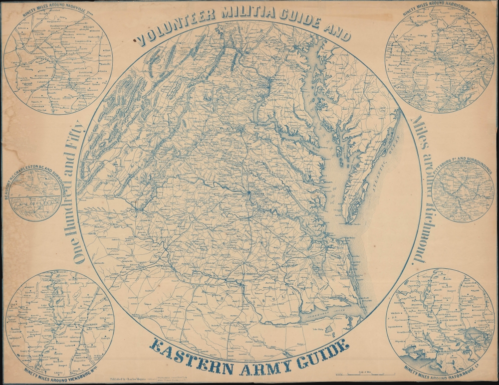
Volunteer Militia Guide and Eastern Army Guide: One Hundred and Fifty Miles around Richmond.
1863 (undated) 22.75 x 29.5 in (57.785 x 74.93 cm) 1 : 920000
1863 (undated) 22.75 x 29.5 in (57.785 x 74.93 cm) 1 : 920000
Description
An extremely rare c. 1863 Charles Magnus broadside map of the Chesapeake, Virginia, Washington D.C. theater of the American Civil War (1861 - 1865). The map records the early days of the war when the Confederacy was rapidly advancing and before the high-water mark at Gettysburg.
A Closer Look
The map is printed on thin paper in blue ink. Coverage embraces roughly 100 miles around Richmond, thus encompassing the primary theater of the early days of the Civil War: the Chesapeake Bay Region, the Richmond-Washington D.C. corridor, and parts of eastern Virginia. Smaller maps detail 'Ninety Miles Around Nashville Tenn.', 'Ninety Miles around Harrisburg Pa.', 'Beaufort N.C. Charleston S.C. and Surroundings', 'Pittsburg Pa. and Surroundings', 'Ninety Miles around Vicksburg Miss.', and 'Ninety Mils around Baton Rouge La.' Battle sites are marked with crossed swords. Major rail lines, vital to the war on both sides, are illustrated.Publication History and Census
This map was engraved and published in New York by Charles Magnus c. 1863. The view is undated, but we do not see any battles predating 1862 and the July 1863 Battle of Gettysburg is not marked, meaning it must have been issued between late 1862 and early 1863. The map likely had a very limited run due to being rapidly outdated by the fast pace of the war. The map is rare. We see just three cataloged examples: the Library of Congress, Boston Public Library, and Pennsylvania State University Libraries.Cartographer
Charles Magnus (1826 - 1900) was a New York City based stationer, illustrator, bookseller, and map and print publisher active in the middle to late 19th century. Magnus was born in Elberfeld, Germany, as Julian Carl Magnus. Fleeing the March Revolution in Germany, the Magnus family immigrated to New York City in 1848. In New York, Charles' brother Carl Emil had already established himself as the editor of a German weekly newspaper, Deutsche Schnellpost. It was through his brother that Magnus learnt the printing and publishing trade. The earliest work to bear the Magnus inscription dated to the 1850s and includes various pictorial broadsides and maps intended to commemorate important events - the most notable for map enthusiasts being his 1855 map of New York commemorating the '79th Year of Independence of the United States'. During the 1860s and years of the American Civil War, Magnus, through various political connections, became one of the few illustrators with unrestricted access to Union military camps. He is consequently particularly well known for his authentic view of Civil War cities, personages, and events. Following the war, Magnus began to develop a prosperous business creating and selling panoramic city views, song sheets, and patriotic envelopes. In all Charles Magnus, with over 1000 known works, was one of the most prolific American printers of broadsides and other lithographs. More by this mapmaker...
Condition
Average. Thin paper. Discoloration and tide marks, left side. Trimmed to neatline, likely by publisher. Upper right corner reinstated. Slight foxing. Multiple minor closed edge tears, stabilized on verso. Some older tape repairs on verso.
References
OCLC 53002619. Library of Congress G3884.R5S5 186- .M34. Boston Public Library, G3884.R5S5 1861 .M35.