
Magnus, Charles

Charles Magnus (1826 - 1900) was a New York City based stationer, illustrator, bookseller, and map and print publisher active in the middle to late 19th century. Magnus was born in Elberfeld, Germany, as Julian Carl Magnus. Fleeing the March Revolution in Germany, the Magnus family immigrated to New York City in 1848. In New York, Charles' brother Carl Emil had already established himself as the editor of a German weekly newspaper, Deutsche Schnellpost. It was through his brother that Magnus learnt the printing and publishing trade. The earliest work to bear the Magnus inscription dated to the 1850s and includes various pictorial broadsides and maps intended to commemorate important events - the most notable for map enthusiasts being his 1855 map of New York commemorating the '79th Year of Independence of the United States'. During the 1860s and years of the American Civil War, Magnus, through various political connections, became one of the few illustrators with unrestricted access to Union military camps. He is consequently particularly well known for his authentic view of Civil War cities, personages, and events. Following the war, Magnus began to develop a prosperous business creating and selling panoramic city views, song sheets, and patriotic envelopes. In all Charles Magnus, with over 1000 known works, was one of the most prolific American printers of broadsides and other lithographs.
One of the most decorative 19th century maps of New York City - here with original full color.
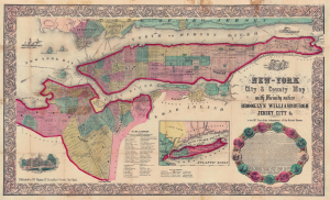
New-York City and County Map with Vicinity entire Brooklyn Williamsburgh Jersey City an c. in the 79th Year of Independence of the United States.
$1,500.00
Acquire
- Digital Map Information
- Suitable for large format printing
- Full resolution TIFF file
- ICC color profile embedded
- Delivered instantly via download link
The rare full-color edition of Charles Magnus's extraordinary 1855 broadside map of New York City, issued to commemorate the signing of the Declaration of Independence. This is one of the finest and most visually striking maps of New York City to appear in the 19th century. Moreover, the present example is only the 2nd full original color example of this map we have seen. (more details)
The Great Republic, Imperiled.
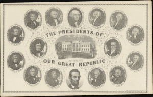
The Presidents of our Great Republic.
$850.00
Acquire
- Digital Map Information
- Suitable for large format printing
- File Size: 2.91 MB
- File Type: ZIP / TIFF
- ICC color profile embedded
- Delivered instantly via download link
A c. 1861 lithographed broadside published by Charles Magnus celebrating the 16 presidents of the United States from Washington to Lincoln. (more details)
The brith of New York Public Transit - view Includes the largest theaters in New York!
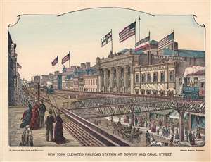
New York Elevated Railroad Station at Bowery and Canal Street.
$325.00
Acquire
- Digital Map Information
- Suitable for large format printing
- Full resolution TIFF file
- ICC color profile embedded
- Delivered instantly via download link
This is a c. 1880 Charles Magnus view of the elevated train station at Bowery and Canal Street in New York City. The focus is on the New York Elevated Railroad, the first public rapid transit system in the United States and an object of considerable popular interest. The view looks across the elevated railroad toward the Thalia Theatre and the Atlantic Garden beer hall. Trains can be seen traveling in both directions and fashionable New Yorkers waiting on the platform in the foreground. Horse-drawn carriages and more well-dressed New Yorkers can be seen on the street below the railroad. (more details)