1943 Owens and Minneapolis Morning Tribune Map of Scandanavia
EffectNorwayInvasion-owens-1943$250.00

Title
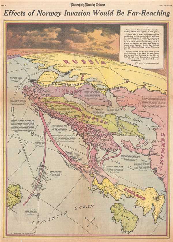
Effects of Norway Invasion Would Be Far-Reaching.
1943 (dated) 22 x 15.75 in (55.88 x 40.005 cm) 1 : 5230000
1943 (dated) 22 x 15.75 in (55.88 x 40.005 cm) 1 : 5230000
Description
This is a Friday, June 18, 1943 Charles Hamilton Owens and Minneapolis Morning Tribune map of the possible Allied invasion of Norway. The map depicts the region from the Arctic Ocean and Iceland to Germany and from Russia to Ireland. During the summer of 1943, following the surrender of Axis forces in North Africa, nearly everyone in the world was waiting to see what the Allies next move would be. Everyone knew that Stalin had been calling for a second front in Europe to ease pressure on Soviet forces in Russia, but no one knew for sure where, or when, that second front would materialize. Hitler had fortified nearly the entire coastline of northern and western Europe, but still had to play a guessing game of where the Allies would strike next. One option, as illustrated here, was to invade Norway. As Owens notes, not all of the Norwegian coast had been fortified by the Nazis, but it also presented natural barriers in the form of steep cliffs. Only certain areas along the Norwegian coast provided adequate landing zones. Owens also states repeatedly that an invasion of Norway would force Germany to transport large numbers of troops across Sweden, which the neutral Swedish had already stated would force them to join the Allied cause, giving Germany yet another variable to watch. While in hindsight the option of an Allied invasion of Norway may appear outlandish, one of the most important factors in the successful Allied landings in Sicily and in Normandy was successfully forcing Germany and her allies to position troops throughout Europe. This meant that there was never an overwhelming concentration of Axis forces in any one location, which allowed for a higher probability of success in any future Allied landing operation.
When Charles Hamilton Owens drew this map, he was doubtless inspired by the work of Richard Edes Harrison, an American illustrator and cartographer who, working for Fortune magazine, pioneered a new style of representing the world for WWII era propaganda maps. Edes developed the convention of using spherical perspective with an exaggerated vertical dimension, as on the present map, to illustrate part of the world as part of a greater global situation. This map was drawn by Charles Hamilton Owens and published in the Minneapolis Morning Tribune on Friday, June 18, 1943.
When Charles Hamilton Owens drew this map, he was doubtless inspired by the work of Richard Edes Harrison, an American illustrator and cartographer who, working for Fortune magazine, pioneered a new style of representing the world for WWII era propaganda maps. Edes developed the convention of using spherical perspective with an exaggerated vertical dimension, as on the present map, to illustrate part of the world as part of a greater global situation. This map was drawn by Charles Hamilton Owens and published in the Minneapolis Morning Tribune on Friday, June 18, 1943.
CartographerS
Charles Hamilton Owens (Feb 16, 1881 - March 3, 1958) was an American painter and illustrator and staff illustrator for the Los Angeles Times. Born in San Francisco, he had a passion for drawing from a young age. After landing a job as a messenger for The San Francisco Examiner, Owens began being taught his trade by the newspaper's illustrators. Although it is unclear exactly where Owens started his career as a newspaper staff artist, his reputation was launched by his detailed sketches of the 1906 San Francisco earthquake and fire for a New York paper, using only wire reports and his knowledge of the city. By 1910, Owens was working for the Los Angeles Examiner. Even at this point in his career, Owens was known for experimenting with new forms of illustration, fusing drawings of events with photographs. Owens's map of the Titanic disaster used a high oblique perspective, 'capturing the earth's sphericity and showing the polar regions on a curving horizon.' By the 1920s, Owens reputation as an artist in Los Angeles had grown beyond the realm of journalism. He had a studio and received commissions for landscapes and had exhibited watercolors of California and Hawaii landscapes. Thus, when Owens began creating his war series in April/May 1942, he had all the necessary skills to create visually striking works. The Los Angeles Times began a series of maps for its readers, which were full-page inserts that would appear every Monday and Saturday. Owens's maps would be included in the Monday issues, and a Rand McNally map would be included on Saturdays. The Rand McNally maps, however, were discontinued on June 27, 1942, but Owens's maps continued to be printed. His last war map was published on September 10, 1945, a little over a week after the Japanese surrender. Owens died in Los Angeles on March 3, 1958. More by this mapmaker...
The Minneapolis Tribune (1867 - present) was founded by Colonel William S. King, William D. Washburn, and Dorilus Morrison and the first issue was published on May 25, 1867. In 1941, the Cowles family of Des Moines, Iowa bought the Tribune and merged it with their other holdings in Minneapolis, giving the Cowles family ownership of all the city's major newspapers. The Tribune became the city's morning newspaper, and the Star-Journal was the evening newspaper. The two published a joint Sunday edition. The newspaper is still published today, under the name Star Tribune. Learn More...
Condition
Very good. Newsprint. Closed minor margin tears professionally repaired on verso. Text on verso.