
Minneapolis Tribune

The Minneapolis Tribune (1867 - present) was founded by Colonel William S. King, William D. Washburn, and Dorilus Morrison and the first issue was published on May 25, 1867. In 1941, the Cowles family of Des Moines, Iowa bought the Tribune and merged it with their other holdings in Minneapolis, giving the Cowles family ownership of all the city's major newspapers. The Tribune became the city's morning newspaper, and the Star-Journal was the evening newspaper. The two published a joint Sunday edition. The newspaper is still published today, under the name Star Tribune.
Printed a week after the Allies secured the surrender of German and Italian forces in North Africa.
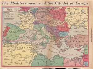
The Mediterranean and the Citadel of Europe.
$200.00
Acquire
- Digital Map Information
- Suitable for large format printing
- File Size: 9.67 MB
- File Type: ZIP / TIFF
- ICC color profile embedded
- Delivered instantly via download link
This is a Friday, May 21, 1943 Van Swearingen and Minneapolis Morning Tribune map of Europe and the Mediterranean a week after the surrender of Italian and German forces in North Africa on May 13, 1943. The map depicts the region from England, the North Sea, and ... (more details)
The third in a series of maps of possible Allied invasions during the summer of 1943.
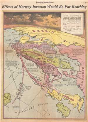
Effects of Norway Invasion Would Be Far-Reaching.
$250.00
Acquire
- Digital Map Information
- Suitable for large format printing
- File Size: 11.68 MB
- File Type: ZIP / TIFF
- ICC color profile embedded
- Delivered instantly via download link
This is a Friday, June 18, 1943 Charles Hamilton Owens and Minneapolis Morning Tribune map of the possible Allied invasion of Norway. The map depicts the region from the Arctic Ocean and Iceland to Germany and from Russia to Ireland. During the summer of 1943, ... (more details)
Includes an incredible view of an imagined Nazi aerial attack on Gibraltar.

Will Hitler Drive Into Spain For Thrust at Gibraltar?
$250.00
Acquire
- Digital Map Information
- Suitable for large format printing
- File Size: 10.45 MB
- File Type: ZIP / TIFF
- ICC color profile embedded
- Delivered instantly via download link
This is a Wednesday, January 6, 1943 Charles Hamilton Owens and Minneapolis Morning Tribune pictorial map of western Europe illustrating a possible Nazi German attack on Gibraltar. The most striking feature on the map is a view of Gibraltar, from the ... (more details)