Digital Image: 1951 Société d'Archéologie Copte Pictorial Map of Christian Egypt
EgypteChretienne-archcopte-1951_d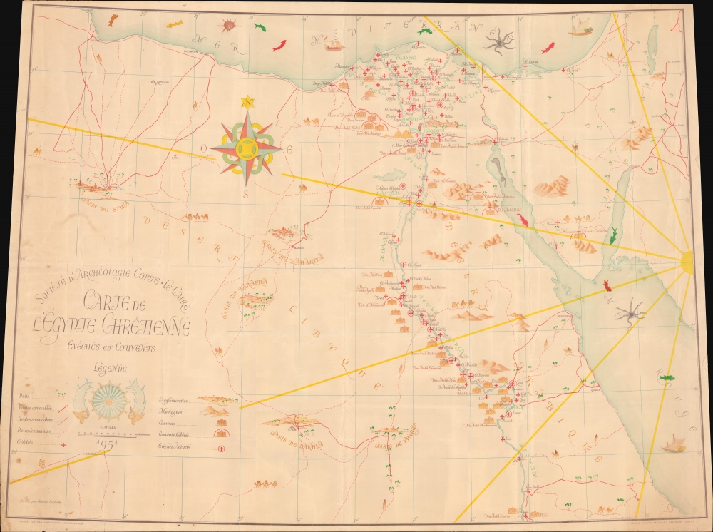


Title
Carte de l'Égypte Chrétienne Evêchés et Couvents.
1951 (dated) 29.25 x 39.5 in (74.295 x 100.33 cm) 1 : 1200000
1951 (dated) 29.25 x 39.5 in (74.295 x 100.33 cm) 1 : 1200000
Description
FOR THE ORIGINAL ANTIQUE MAP, WITH HISTORICAL ANALYSIS, CLICK HERE.
Digital Map Information
Geographicus maintains an archive of high-resolution rare map scans. We scan our maps at 300 DPI or higher, with newer images being 600 DPI, (either TIFF or JPEG, depending on when the scan was done) which is most cases in suitable for enlargement and printing.
Delivery
Once you purchase our digital scan service, you will receive a download link via email - usually within seconds. Digital orders are delivered as ZIP files, an industry standard file compression protocol that any computer should be able to unpack. Some of our files are very large, and can take some time to download. Most files are saved into your computer's 'Downloads' folder. All delivery is electronic. No physical product is shipped.
Credit and Scope of Use
You can use your digial image any way you want! Our digital images are unrestricted by copyright and can be used, modified, and published freely. The textual description that accompanies the original antique map is not included in the sale of digital images and remains protected by copyright. That said, we put significant care and effort into scanning and editing these maps, and we’d appreciate a credit when possible. Should you wish to credit us, please use the following credit line:
Courtesy of Geographicus Rare Antique Maps (https://www.geographicus.com).
How Large Can I Print?
In general, at 300 DPI, you should at least be able to double the size of the actual image, more so with our 600 DPI images. So, if the original was 10 x 12 inches, you can print at 20 x 24 inches, without quality loss. If your display requirements can accommodate some loss in image quality, you can make it even larger. That being said, no quality of scan will allow you to blow up at 10 x 12 inch map to wall size without significant quality loss. For more information, it is best consult a printer or reprographics specialist.
Refunds
If the high resolution image you ordered is unavailable, we will fully refund your purchase. Otherwise, digital images scans are a service, not a tangible product, and cannot be returned or refunded once the download link is used.
Cartographer S
Charles Bachatly (1909 - 1957) was an archaeologist and founding member of the Société d'Archéologie Copte in Cairo, Egypt. He served as the Society's general secretary from 1934 until 1957 and as its first librarian during the same period. He uncovered the Monastery of St. Phoebammon south of Luxor on the west bank of the Nile in 1947 and 1948. Bachatly was also foundational in creating the Society's publications and organized the first exhibition of Coptic art in Egypt in 1944. More by this mapmaker...
The Société d'Archéologie Copte (1934 - Present) is an archaeological society founded in Cairo, Egypt. Originally founded as the Association des Amis des Église et de l'Art Coptes, the name was changed to the Société d'Archéologie Copte in 1937. The Society was founded as a center for research and publication related to the Coptic era. The Society also helped found the International Association for Coptic Studies in 1975. It is an entirely independent scientific institution and is not affiliated with any church body. It began publishing the Bulletin de la Société d'Archéologie Copte in 1936, making it the oldest and first periodical dedicated to Coptology. Learn More...
References
OCLC 1296669343, 1073623445.