1773 Cook Maps of the Endeavor River and Botany Bay, New South Wales, Australia
EndeavourRiverBotanyBay-cook-1773$700.00

Title
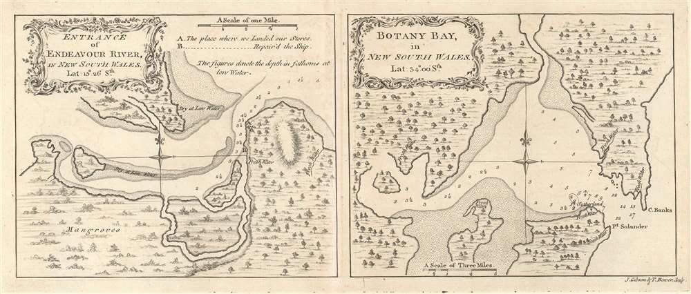
Entrance of Endeavour River, in New South Wales. / Botany Bay, in New South Wales.
1773 (undated) 6.5 x 14 in (16.51 x 35.56 cm) 1 : 37000 / 1 : 149000
1773 (undated) 6.5 x 14 in (16.51 x 35.56 cm) 1 : 37000 / 1 : 149000
Description
This is a 1773 Captain James Cook set of two maps of the entrance to the Endeavour River and Botany Bay in Australia, both of which Cook discovered on his first voyage. Each map focuses on its respective region, with the Endeavour River on the left and Botany Bay on the right.
Entrance of Endeavour River
The map of the entrance to the Endeavor River illustrates a significant part of Cook's first voyage, as he was forced to beach his ship, the Endeavour at the mouth of the river for seven weeks to undergo repairs after the ship hit the Endeavour Reef. Since Cook and his crew were in effect marooned in this remote part of the world, they made the best of their situation by making contact with the local Guugu Yimithirr Aborigines, collecting samples of the local flora, and making sketches of the flora and fauna found in the region. Cook is also responsible for naming the river, bestowing upon it the name of the ship that was beached on its banks for nearly two months. Mangroves, where to find fresh water, and the depth of the river at 'low water' are noted, giving the viewer some idea of the area.Botany Bay
Just as Cook was the first European to set eyes on the Endeavour River, he also has the distinction of being the first European to enter Botany Bay. From Cook's official journal of the voyage, it is said that the name 'Botany Bay' came about because of the large number of botanical specimens his naturalists, Mr. Banks and Dr. Solander, were able to collect in the region. It is known that Cook and others on the voyage originally named the bay Stingray Bay due to the variety of fish they found living in the bay. It is unclear why Cook changed his mind as to the bay's name. The map itself illustrates the bay including both Georges River and Cooks River. Depth soundings throughout the bay indicate water depth in fathoms at low tide. Locations of fresh water are also noted.Census and Publication History
This map was engraved by John Gibson and Thomas Bowen and published in the first official account of Captain Cook's first voyage. This map is present in the collection of around twenty institutions and it is scarce on the private market.CartographerS
Captain James Cook (7 November 1728 - 14 February 1779) is a seminal figure in the history of cartography for which we can offer only a cursory treatment here. Cook began sailing as a teenager in the British Merchant Navy before joining the Royal Navy in 1755. He was posted in America for a time where he worked Samuel Holland, William Bligh, and others in the mapping of the St. Lawrence River and Newfoundland. In 1766 Cook was commissioned to explore the Pacific and given a Captaincy with command of the Endeavour. What followed were three historic voyages of discovery, the highlights of which include the first European contact with eastern Australia, the discovery of the Hawaiian Islands (among many other Polynesian groups), the first circumnavigation of New Zealand, some of the first sightings of Antarctica, the first accurate mapping of the Pacific Northwest, and ultimately his own untimely death at the hands of angry Hawaiians in 1779. The influence of Cook work on the mapping and exploration of the Pacific cannot be understated. More by this mapmaker...
John Gibson (1724 – 1773) was an English map engraver active in London at the end of the 18th century. Gibson was the son of a locksmith. In 1739 he apprenticed to John Blundell as a stationer of Grub Street. Gibson proved a fine engraver and was much in demand by London map publishers. During his career he produced thousands of maps and was admired as a skilled engraver and sculptor. Among others, he engraved for Emanuel Bowen, Robert Sayer, Jean Palairet, John Rocque, Andrew Dury, and Benjamin Martin. His best known work was prepared in conjunction with Gentleman's Magazine. Gibson, sadly, was not as astute in his fiscal affairs as with the engravers pen and consequently spent much of his life consigned to debtor's prison. Learn More...
Thomas Bowen (b. c. 1733 - March 1790) was a Welsh engraver of maps and charts. He was the son of Emanuel Bowen (1693/4–1767), under whom he had apprenticed. His work was printed with his father's, as well as other publishers throughout the latter half of the eighteenth century. He married Alice Downes on December 25, 1768. He appears even thento have not been successful, and more than once found himself a debtor. He was imprisoned for debt in 1761, and he met his death in 1790 in Clerkenwell workhouse. Learn More...
Condition
Very good. Even overall toning. Light wear along original centerfold. Blank on verso.
References
Rumsey 3403.047. OCLC 53453596.