1873 Admiralty Nautical Chart of Maritime Map of the West Coast of England
EnglandWestCoast-admiralty-1873$250.00

Title
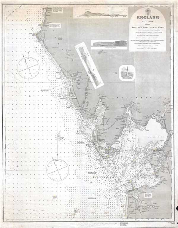
England West Coast. Fleetwood to the Firth of Solway.
1873 (dated) 25.25 x 19.25 in (64.135 x 48.895 cm) 1 : 154000
1873 (dated) 25.25 x 19.25 in (64.135 x 48.895 cm) 1 : 154000
Description
This is an 1873 Admiralty nautical chart or maritime map of the west coast of England. The map depicts the region from Harrington, near the Lake District, to Blackpool, a seaside resort town. Myriad depth soundings are included all along the coastline and highly detailed illustrations of the Duddon Estuary and Morecambe Bay are present. The Dudden Channel is marked in the Duddon Estuary, along with the Ulverstone Channel, Grange Channel, and Haysham Lake in Morecambe Bay. Coastal towns are labeled throughout the region, including Harrington, Whitehaven, St. Bees, Ravenglass, Barrow, Ulverstone, Lancaster, Fleetwood, and Blackpool. Points, heads, and other coastal landmarks are also labeled, and the lighthouses are indicated by yellow and red circles. Navigational notes are included at certain points between Harrington and Blackpool. Coast railways, including the Whitehaven and Furness Railway, the Furness Railway, the Ulverstone and Lancaster Railway, and the Lancaster and Carlisle Railway are illustrated and labeled as well. Little inland detail is shown, however three charming coastal views and a view of the Monument to Sir. J. Barrow, Secretary to the Admiralty, are situated in the inland portion of the map.
The content for this map was originally surveyed by Captain H. Denham and Commander G. Williams in 1846 and Staff Commander Richards resurveyed Morecambe Bay in 1871. The whole was compiled by the Admiralty and published in 1873.
The content for this map was originally surveyed by Captain H. Denham and Commander G. Williams in 1846 and Staff Commander Richards resurveyed Morecambe Bay in 1871. The whole was compiled by the Admiralty and published in 1873.
CartographerS
The British Admiralty Office (1795 - Present) or the United Kingdom Hydrographic Office refers to the Branch of the English government that is responsible for the command of the British Navy. In 1795 King George III created the United Kingdom Hydrographic Office, known in short as the U.K.H.O., to provide top notch nautical charts to the vast Royal Navy. Prior the founding of the Admiralty the surveying and creation of nautical charts was primarily a commercial venture wherein the cartographer himself, more of than not, actually financed the printing of his own material. The great navigator Cook himself is known to have scrambled for funds to publish his own seminal charts - the most important and advanced of the period. The system of privately funded nautical mapping and publishing left vast portions of the world uncharted and many excellent charts unpublished. King George III, responding significant loss in trade revenue related to shipwrecks and delay due to poor charts, recognized the need for an institutionalized government sponsored cartographic agency - the Admiralty. The first head of the Admiralty, a position known as Hydrographer, was the important cartographer Alexander Dalrymple. Dalrymple started by organizing and cataloging obtainable charts before initiating the laborious process of updating them and filling in the blanks. The first official Admiralty Chart appeared in 1800 and detailed Quiberon Bay in Brittany. By 1808 the position of Hydrographer fell to Captain Thomas Hurd. Hurd advocated the sale of Admiralty charts to the general public and, by the time he retired in 1829, had issued and published some 736 charts. Stewardship of the organization then passed to Rear Admiral Sir Francis Beaufort. It was under Beaufort's administration that the Admiralty truly developed as a "chart making" as opposed to a "chart cataloging" institution. Beaufort held his post from 1829 to 1854. In his 25 years at the Admiralty Beaufort created nearly 1500 new charts and sponsored countless surveying and scientific expeditions - including the 1831 to 1836 voyage of the H.M.S. Beagle. By 1855 the Admiralty's chart catalog listed some 1,981 charts. More by this mapmaker...
John Walker (1787 - April 19, 1873) was a British map seller, engraver, lithographer, hydrographer, geographer, draughtsman, and publisher active in London during the 19th century. Walker published both nautical charts and geographical maps. His nautical work is particularly distinguished as he was an official hydrographer for the British East India Company, a position, incidentally, also held by his father of the same name. Walker's maps, mostly published after 1827, were primarily produced with his brothers Charles Walker and Alexander Walker under the imprint J. and C. Walker. Among their joint projects are more than 200 maps for the influential Society for the Diffusion of Useful Knowledge Atlas (SDUK). In addition they published numerous charts for James Horsburgh and the British Admiralty Hydrographic Office, including Belcher's important map of Hong Kong and Carless' exploratory map of Karachi. The J. and C. Walker firm continued to publish after both Walkers died in the 1870s. Learn More...
Condition
Good. Wear along margins. Light soiling. Blank on verso.
References
OCLC 903653245.