1589 / 1597 Bünting Map of Europe in the form of a Queen (Europa Regina)
Europe-bunting-1589$1,900.00


Title
Europa Prima Pars Terrae In Forma Virginis.
1589 (undated) 10.5 x 14 in (26.67 x 35.56 cm)
1589 (undated) 10.5 x 14 in (26.67 x 35.56 cm)
Description
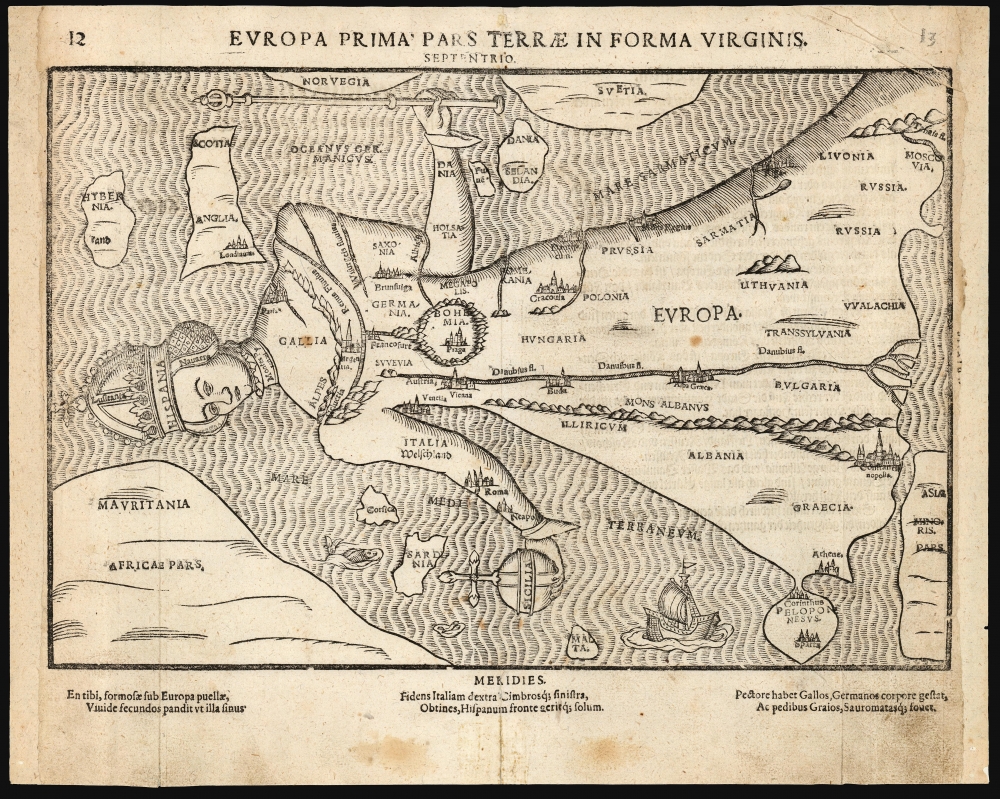
This is Heinrich Bünting's 1589 / 1597 Europa Regina: a map of the continent of Europe, in the form of a woman. This striking woodcut appeared in Bünting's Itinerarium Sacrae, the first and for many years the only complete work of biblical geography.
The major rivers of Central Europe are depicted, most prominently the Danube. Europe's mountains are very stylized, with the Alps forming the neckline of Europa's gown. An array of cities are shown pictorially: London, Paris, Strasbourg (Argentina), Brunswick, Frankfurt, Prague, Vienna, Venice, Rome, Naples, Krakow, Buda, Belgrade (Alba Graeca), Riga, Constantinople, Athens, Corinth, and Sparta.
A Closer Look
Bünting uses the map as a mnemonic to better learn and memorize Europe's geography, and explains the elements on the verso of the map: the crowned head represents Spain with Portugal; France is the chest, although Germany is the heart; The Alps and the river Rhine are two necklaces, from which are suspended a great jewel: Bohemia. Italy forms the right arm, with Sicily representing an imperial orb. The left arm is Denmark. Along the lower border of the queen’s skirt are Greece, the Peloponnesus, and the Baltic lands up to Muscovy.The major rivers of Central Europe are depicted, most prominently the Danube. Europe's mountains are very stylized, with the Alps forming the neckline of Europa's gown. An array of cities are shown pictorially: London, Paris, Strasbourg (Argentina), Brunswick, Frankfurt, Prague, Vienna, Venice, Rome, Naples, Krakow, Buda, Belgrade (Alba Graeca), Riga, Constantinople, Athens, Corinth, and Sparta.
Europa Regina
The symbolization of Europe with a princess or queen derive from ancient myths of the Phoenician princess Europa, but the first printed anthropomorphic map of Europe in this form, known as a Europa Regina, was produced in 1537 by Johannes Putsch (1516 - 1542), a courtier of the Tyrol, who accompanied the image with a poem explaining the symbolism. It was Putsch's sole cartographic work to survive in print, and it was likely scarce even when Bünting copied it: there is now only a single surviving copy of the Putsch in the Tiroler Landesmuseum Ferdinandeum, Innsbruck. That map was dedicated to his patron Ferdinand I, at the time that he was King of Bohemia, Hungary, and Croatia, and Archbishop of Austria. His brother, Charles V, was then Holy Roman Emperor.Publication History and Census
This map is frequently found dated 1581, corresponding to the first Helmstadt edition of Bünting's Itinerarium. Scrutiny of editions of the work in institutional collections indicates that neither this map, nor the accompanying maps of Asia and Africa, were introduced until either the 1587 or 1589 Magdeburg edition. The incorrect dating of these appears to be influenced by the cataloging of Bünting's famous cloverleaf world map, which was included in the 1581 and 1582 Helmstadt editions. This example conforms to the 1597 state of the map. We see twelve examples of the separate map in OCLC, in various editions. The Itinerarium Sacrae Scripturae appears in many editions in institutional collections.CartographerS
Heinrich Bünting (1545 – 1606) was a Protestant pastor and theologian. He was born in Hanover, and studied theologian Witemberg. He is best known for his book of woodcut maps titled Itinerarium Sacrae Scripturae (Travel book through Holy Scripture) first published in 1581. It was the first complete summary of biblical geography available. More by this mapmaker...
Johannes Putsch or Bucius (March 28, 1516 - January 19, 1542) was a Tyrolean courtier and poet. He was born in Innsbruck to royal secretary Wilhelm Putsch (ca. 1480–1551). He was educated at the gymnasium in Innsbruck, joining at 14 the entourage of Ferdinand I. He did travel during this period, including a 1530 journey to Italy during which he seems to have established himself as a poet and mathematician.In 1535 he matriculated at the university of Orléans; after his time at university he returned to Austria to continue his service with Ferdinand as a 'royal councillor and supreme private field secretary.' It was possible that during the campaign in Hungary he received an Imperial knighthood. In spite of his reputation, Putsch has only one printed work surviving him, and that in only a single copy: his 1537 anthropomorphic map of Europe, dedicated to Ferdinand I. Some forty years later, Heinrich Bünting would produce a version of the map in the later editions of his Itinerariums, and Sebastian Petri would add a version in the later editions of Münster's Cosmographey. Learn More...
Source
Bünting, Heinrich, Itinerarium Sacrae Scripturae, (Magdeburg) 1597.
Condition
Good. Evenly toned, few spots. Marginal staining from old mends. Trimmed borders at left and right, with loss of marginal text. Map image not impacted.
References
OCLC 164584476. Rumsey 15301.005 (1589) Karrow, Robert W. Mapmakers of the Sixteenth Century and Their Maps 61/1.2 (incorrectly dated 1581).