1939 Harrison Map of Europe
Europe1939-harrison-1939$400.00

Title
Europe 1939.
1939 (dated) 21.25 x 26.75 in (53.975 x 67.945 cm) 1 : 7000000
1939 (dated) 21.25 x 26.75 in (53.975 x 67.945 cm) 1 : 7000000
Description
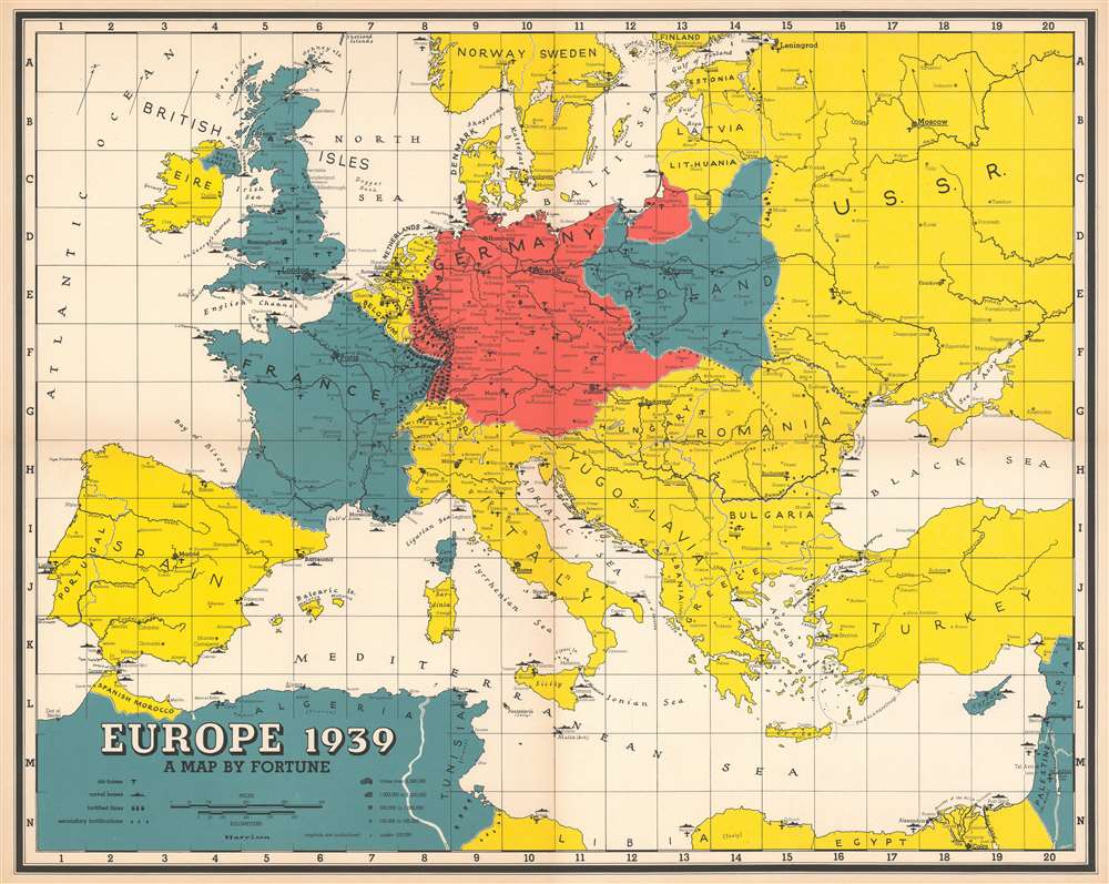
This is a 1939 Richard Edes Harrison map of Europe on the brink of World War II. Depicting the entirety of continental Europe, Harrison employs small icons to indicate air and naval bases as well as fortified lines along international borders. The fortifications built between France and Germany, the vaunted Maginot and Siegfried Lines respectively, represent the highest concentration of illustrated military force. Harrison also uses color to identify military alliances as they stood when this map was published. The Allied powers, France, the United Kingdom, and Poland, are shaded blue, while Germany is colored red. It is important to note that Germany’s borders here include the Anschluss, or the Reich’s forced annexation of Austria, and its invasion of Czechoslovakia, neither of which were opposed by the Western powers. World War II began in earnest in Europe on September 1, 1939, when Germany invaded Poland from the west, and France and Great Britain declared war on Germany, but did little to come to Poland’s defense. As agreed in the Molotov-Ribbentrop Pact between Nazi Germany and the Soviet Union, the Soviets invaded Poland on September 17th. The Soviets would not join the Allied side until Operation Barbarossa (Unternehmen Barbarossa) the June 22, 1941 German invasion of the Soviet Union.
Publication History and Census
This map was created by Richard Edes Harrison and published by FORTUNE Magazine. It is catalogued in the OCLC as being part of the institutional collections at Harvard, the University of Michigan, Missouri State University, the University of Texas, Brigham Young University, the University of California, Los Angeles, and the University of California-Berkeley.Cartographer
Richard Edes Harrison (1902 - January 5, 1994) was an American cartographer and cartoonist active in the middle part of the 20th century. Harrison is credited with redefining cartography, especially journalistic cartography, by employing spherical perspective, bold shading, and graphic design to both make maps more publicly accessible and give them an artistic dimension. Harrison was born in Baltimore and studied design at Yale, graduating in 1923, before relocating to New York City at the height of the Great Depression. He made ends meet through industrial design work, creating everything from bottles to ashtrays. His first foray into the cartographic world was a fill-in job at Fortune magazine. The editors at Fortune must have admired his work for it launched a long-standing collaboration. His work, doubtless inspired by the age of air travel, became exceptionally popular during World War II, where his unique approach and political charged subject matter illustrated the seats of war with exceptional poignancy and clarity. After the war, Harrison continued to produce maps from his base in New York City. In his spare time he was an avid ornithologist and was commonly seen in Central Park in search of rare bird sightings. More by this mapmaker...
Condition
Very good. Light wear along original fold lines. Text on verso.
References
OCLC 34121571.