
Harrison, Richard Edes

Richard Edes Harrison (1902 - January 5, 1994) was an American cartographer and cartoonist active in the middle part of the 20th century. Harrison is credited with redefining cartography, especially journalistic cartography, by employing spherical perspective, bold shading, and graphic design to both make maps more publicly accessible and give them an artistic dimension. Harrison was born in Baltimore and studied design at Yale, graduating in 1923, before relocating to New York City at the height of the Great Depression. He made ends meet through industrial design work, creating everything from bottles to ashtrays. His first foray into the cartographic world was a fill-in job at Fortune magazine. The editors at Fortune must have admired his work for it launched a long-standing collaboration. His work, doubtless inspired by the age of air travel, became exceptionally popular during World War II, where his unique approach and political charged subject matter illustrated the seats of war with exceptional poignancy and clarity. After the war, Harrison continued to produce maps from his base in New York City. In his spare time he was an avid ornithologist and was commonly seen in Central Park in search of rare bird sightings.
An ominous look at Japan's expansionism during the 1930s.
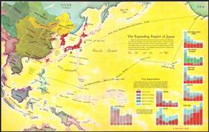
The Expanding Empire of Japan.
$175.00
Acquire
- Digital Map Information
- Suitable for large format printing
- File Size: 14.65 MB
- File Type: ZIP / TIFF
- ICC color profile embedded
- Delivered instantly via download link
This is a 1936 Antonio Petruccelli and Richard Edes Harrison map of the world highlighting the advance of the Japanese Empire in the Pacific. Depicting from Calcutta to San Francisco and from Alaska to Australia, Petruccelli and Harrison paint Japan and Korea (then occupied by the Japanese) deep red. Petruccelli and Harrison then use red to indicate areas of land and sea military advance, along with areas of increased economic activity and control. The Japanese established the puppet state of Manchukuo in 1932, after invading northeastern China. Within a year of this map's publication, Imperial Japan would launch the Second Sino-Japanese War, which would expand into the Pacific War with the United States after the surprise attack on Pearl Harbor on December 7, 1941.
Red arrows emphasize Japan's advance through Manchukuo into northern China, while designs that look like ship's wakes, spread in every direction from Japan and overtake Formosa, the Marianas Islands, Caroline, Islands, and Marshall Islands, among others. No country in the region is immune from an increase in Japanese economic influence, as is evident by the starburst patterns along their coastlines. Bar graphs in the lower right corner visually present this 'yen imperialism', as it is referred to here. Petruccelli and Harrison make Japan's economic and expansionist ambitions immediately apparent, and it likely created feelings of foreboding in its viewers when it was published. (more details)
Red arrows emphasize Japan's advance through Manchukuo into northern China, while designs that look like ship's wakes, spread in every direction from Japan and overtake Formosa, the Marianas Islands, Caroline, Islands, and Marshall Islands, among others. No country in the region is immune from an increase in Japanese economic influence, as is evident by the starburst patterns along their coastlines. Bar graphs in the lower right corner visually present this 'yen imperialism', as it is referred to here. Petruccelli and Harrison make Japan's economic and expansionist ambitions immediately apparent, and it likely created feelings of foreboding in its viewers when it was published. (more details)
Details continental Europe and its military installations on the brink of World War II.
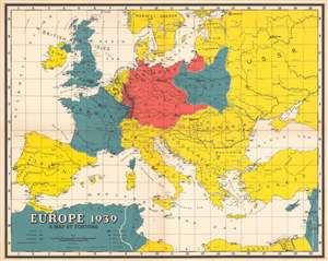
Europe 1939.
$400.00
Acquire
- Digital Map Information
- Suitable for large format printing
- File Size: 28.53 MB
- File Type: ZIP / TIFF
- ICC color profile embedded
- Delivered instantly via download link
This is a 1939 Richard Edes Harrison map of Europe on the brink of World War II. Depicting the entirety of continental Europe, Harrison employs small icons to indicate air and naval bases as well as fortified lines along international borders. The fortifications built between France and Germany, the vaunted Maginot and Siegfried Lines respectively, represent the highest concentration of illustrated military force. Harrison also uses color to identify military alliances as they stood when this map was published. The Allied powers, France, the United Kingdom, and Poland, are shaded blue, while Germany is colored red. It is important to note that Germany’s borders here include the Anschluss, or the Reich’s forced annexation of Austria, and its invasion of Czechoslovakia, neither of which were opposed by the Western powers. World War II began in earnest in Europe on September 1, 1939, when Germany invaded Poland from the west, and France and Great Britain declared war on Germany, but did little to come to Poland’s defense. As agreed in the Molotov-Ribbentrop Pact between Nazi Germany and the Soviet Union, the Soviets invaded Poland on September 17th. The Soviets would not join the Allied side until Operation Barbarossa (Unternehmen Barbarossa) the June 22, 1941 German invasion of the Soviet Union. (more details)
Brilliant, data rich depiction of mid-century New York.
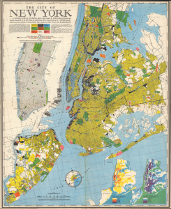
The City of New York.
$500.00
Acquire
- Digital Map Information
- Suitable for large format printing
- File Size: 53.04 MB
- File Type: ZIP / TIFF
- ICC color profile embedded
- Delivered instantly via download link
This 1939 Richard Edes Harrison map of New York City - published in conjunction with the New York World's Fair - represents a triumph of the visual display of quantitative information. Its aesthetic impact is all the more impressive in its clear expression of municipal and demographic data, making this a map of the people of New York City, as much as of the physical city itself. All five boroughs are represented in the primary map. On it, Harrison's masterful use of vivid color to distinguish between residential, commercial, industrial, and federal use of land is clear yet supple, able to clearly present (for example) low-income housing projects using the same palette. Parks and cemeteries both appear as green spaces, with white spots - evoking headstones - indicating the difference between the two. The two major airports (Floyd Bennett Field and North Beach Airport) are given their own color as well. The city's industrial areas, shown in black, dominate the East River and Hudson coastlines, a reminder of the centrality of trade to the city's development and history. (more details)
Focuses on the military situation in Europe between the beginning of World War II and the German invasion of France and the Low Countries.
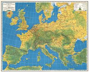
Major George Fielding Eliot's Strategy Map of Europe.
$400.00
Acquire
- Digital Map Information
- Suitable for large format printing
- File Size: 57.53 MB
- File Type: ZIP / TIFF
- ICC color profile embedded
- Delivered instantly via download link
This is a 1940 Richard Edes Harrison and George Fielding Eliot map of Europe during the 'Phoney War'. 'Phoney War' is the name given to the period at the beginning of World War II between September 3, 1939, when the United Kingdom and France declared war on Nazi Germany, and May 10, 1940, when Germany launched its invasion of France and the Low Countries. Very little fighting occurred between the Western Allies and Germany during these eight months, which led U.S. Senator William Borah to comment in September, 'There is something phoney about this war'. This collaboration between Eliot and Harrison provides an impressive overview of the military situation during this period of relative calm. The Maginot Line and Siegfried Line, fortification systems built by France and Germany respectively along the border between their respective countries, are immediately evident due to the high concentration of symbols illustrating fortifications and air bases in the area. Air and naval bases are identified throughout continental Europe and the U.K., along with oil fields, oil pipelines, and railroads. Color is used to illustrate topography. A key situated in the upper right corner explains the different notations used. (more details)
Harrison's approaches to Japan in Newsmap form.
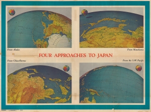
Four Approaches to Japan. Volume III No. 3B / NEWSMAP. For the Armed Forces. 243rd Week of the War - 125th Week of U.S. Participation. Volume III No. 3F.
$275.00
Acquire
- Digital Map Information
- Suitable for large format printing
- Full resolution TIFF file
- ICC color profile embedded
- Delivered instantly via download link
This is a 1944 Army Information Branch double-sided Newsmap for the week of April 27 to May 4, 1944. It was issued on May 8, 1944. One side of the map features four Richard Edes Harrison map views depicting the four approaches to Japan. The other includes information and photographs from both the Italian and Pacific campaigns and a map depicting the pre-invasion air offensive undertaken by the Allies, which presents continental Europe from England and Spain to Leningrad and the Black Sea and from Oslo and the North Sea to Naples, Greece, and Turkey. (more details)