1946 Herault Pictorial Map of Europe
EuropeProduction-herault-1946$500.00

Title
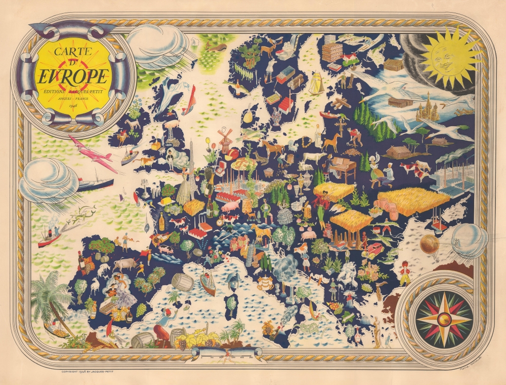
Carte D'Europe.
1946 (dated) 21 x 28 in (53.34 x 71.12 cm) 1 : 7000000
1946 (dated) 21 x 28 in (53.34 x 71.12 cm) 1 : 7000000
Description
This is Pierre Hérault's 1946 curious pictorial map of Europe. Produced in the wake of World War II (1939 - 1945), when much of Europe was in physical and economic ruin, the map presents a bucolic, lively continent with a bright future.
No mention is made of Communism or the brewing Cold War; factories, fields, and a Russian Orthodox cross present a mixed picture of the Soviet Union. Even more unexpectedly, no reference is made to the recent destructive war, which touched every corner of Europe. In fact, the overwhelming feeling is one of peace and prosperity, including a smiling sun at the top-right (rising in the east, the dawn of a new day). It can be inferred that Hérault wanted to move on from the past (perhaps due to his own dubious record during the war) and promote a more integrated Europe focused on economic development rather than nationalism and war.
A Closer Look
The entire continent of Europe, from the British Isles to the Ural Mountains, is illustrated without national borders. Illustrations reflect local industries, culture, and landmarks, including an elegant woman next to the Eiffel Tower, reminiscent of Hérault's interwar illustrations for fashion and culture magazines (see biography below). Some of the illustrations are unusual or meant to be humorous, including Napoleon's head superimposed on Corsica, a large ghost in Scotland, and unflattering passé portrayals of North Africans and Turks.No mention is made of Communism or the brewing Cold War; factories, fields, and a Russian Orthodox cross present a mixed picture of the Soviet Union. Even more unexpectedly, no reference is made to the recent destructive war, which touched every corner of Europe. In fact, the overwhelming feeling is one of peace and prosperity, including a smiling sun at the top-right (rising in the east, the dawn of a new day). It can be inferred that Hérault wanted to move on from the past (perhaps due to his own dubious record during the war) and promote a more integrated Europe focused on economic development rather than nationalism and war.
Sunny Skies Ahead?
Hérault's portrayal of postwar Europe is unusual for being so hopeful at this early date. In fact, most of Europe (including the victorious countries) was suffering immensely, making Hérault seem like either a crank or a clairvoyant. Many of Europe's great cities were in ruins, with Warsaw effectively completely destroyed and several German cities like Berlin and Dresden nearly so. There was little economic activity to speak of outside of shady black markets, and significant parts of the adult male population were either in the military, prisoners of war, injured, or dead, especially in Germany. Food production was so paltry that even the wealthiest parts of Europe were on the brink of starvation. Millions of refugees wandered the continent, fleeing the Soviets or trying to piece together their lives after being displaced. As in the aftermath of the World War I (1914 - 1918), Socialism and Communism found a receptive audience amid the misery, which now had a millions-strong Soviet Red Army in Eastern Europe as a bulwark. Few could have predicted at the time that within a handful of years, (West) Germany, France, Italy, Britain, and other countries would be in the early stages of an economic 'miracle' much more in line with the rosy picture Hérault presents here.Publication History and Census
This pictorial map was drawn by Pierre Hérault and published in Angers by Éditions Jacques-Petit. A second, seemingly identical (aside from the date) printing appeared in 1955 when the map's optimistic tone was more reflective of contemporary social and economic conditions. The map appears on the market from time to time but seems to be absent from institutional collections.Cartographer
Pierre René Hérault (1900 - 1982) was a French illustrator and artist. He was best known for his lively, Art Deco-inspired, humorous, and often very racy (practically pornographic) illustrations for French magazines such as Fantasio, La Rire, and Le Sourire. These highly-stylized cartoons celebrated the sexual independence of the 'flapper girls' of the era and mocked traditional mores. Herault also produced advertisements for a range of products, but most often cosmetics, perfumes, shampoo, and related products, including the likes of L'Oreal, as well as Dubonnet aromatized wine, which was marketed heavily towards women. Hérault also occasionally illustrated books. For example, during the Second World War, he illustrated a French edition of Machiavelli's satirical play The Mandrake, published in 1943 in Angers by Éditions Jacques Petit, which may have been intended as an oblique criticism of the Vichy regime and German occupation (exactly 666 copies of the work were printed; at the same time, he had illustrated a 1941 book titled La Vie d'honneur du Maréchal Pétain Racontée et Illustrée pour les Jeunes Français). The details of Hérault's life are scant, aside from his being born and dying in Cholet, in the Maine-et-Loire département in western France, though he almost certainly lived in Paris during the most productive phase of his career in the 1920s and 1930s. His cartographic production is limited to a surprisingly upbeat pictorial map of Europe published in 1946, reflecting hopes for a postwar revival of the continent's fortunes. More by this mapmaker...
Condition
Good. Closed and repaired tear passing through cloud extending about 6 inches into the map from right side.
References
OCLC 1077728489.