Digital Image: 1946 Herault Pictorial Map of Europe
EuropeProduction-herault-1946_d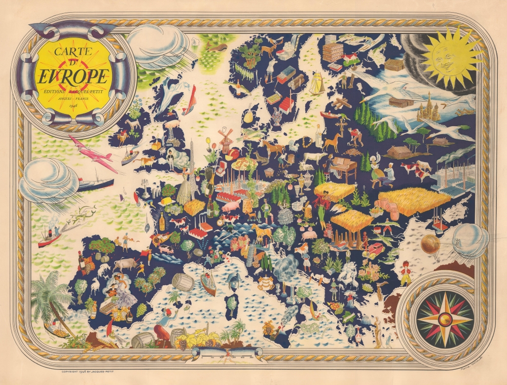

Title
Carte D'Europe.
1946 (dated) 21 x 28 in (53.34 x 71.12 cm) 1 : 7000000
1946 (dated) 21 x 28 in (53.34 x 71.12 cm) 1 : 7000000
Description
FOR THE ORIGINAL ANTIQUE MAP, WITH HISTORICAL ANALYSIS, CLICK HERE.
Digital Map Information
Geographicus maintains an archive of high-resolution rare map scans. We scan our maps at 300 DPI or higher, with newer images being 600 DPI, (either TIFF or JPEG, depending on when the scan was done) which is most cases in suitable for enlargement and printing.
Delivery
Once you purchase our digital scan service, you will receive a download link via email - usually within seconds. Digital orders are delivered as ZIP files, an industry standard file compression protocol that any computer should be able to unpack. Some of our files are very large, and can take some time to download. Most files are saved into your computer's 'Downloads' folder. All delivery is electronic. No physical product is shipped.
Credit and Scope of Use
You can use your digial image any way you want! Our digital images are unrestricted by copyright and can be used, modified, and published freely. The textual description that accompanies the original antique map is not included in the sale of digital images and remains protected by copyright. That said, we put significant care and effort into scanning and editing these maps, and we’d appreciate a credit when possible. Should you wish to credit us, please use the following credit line:
Courtesy of Geographicus Rare Antique Maps (https://www.geographicus.com).
How Large Can I Print?
In general, at 300 DPI, you should at least be able to double the size of the actual image, more so with our 600 DPI images. So, if the original was 10 x 12 inches, you can print at 20 x 24 inches, without quality loss. If your display requirements can accommodate some loss in image quality, you can make it even larger. That being said, no quality of scan will allow you to blow up at 10 x 12 inch map to wall size without significant quality loss. For more information, it is best consult a printer or reprographics specialist.
Refunds
If the high resolution image you ordered is unavailable, we will fully refund your purchase. Otherwise, digital images scans are a service, not a tangible product, and cannot be returned or refunded once the download link is used.
Cartographer
Pierre René Hérault (1900 - 1982) was a French illustrator and artist. He was best known for his lively, Art Deco-inspired, humorous, and often very racy (practically pornographic) illustrations for French magazines such as Fantasio, La Rire, and Le Sourire. These highly-stylized cartoons celebrated the sexual independence of the 'flapper girls' of the era and mocked traditional mores. Herault also produced advertisements for a range of products, but most often cosmetics, perfumes, shampoo, and related products, including the likes of L'Oreal, as well as Dubonnet aromatized wine, which was marketed heavily towards women. Hérault also occasionally illustrated books. For example, during the Second World War, he illustrated a French edition of Machiavelli's satirical play The Mandrake, published in 1943 in Angers by Éditions Jacques Petit, which may have been intended as an oblique criticism of the Vichy regime and German occupation (exactly 666 copies of the work were printed; at the same time, he had illustrated a 1941 book titled La Vie d'honneur du Maréchal Pétain Racontée et Illustrée pour les Jeunes Français). The details of Hérault's life are scant, aside from his being born and dying in Cholet, in the Maine-et-Loire département in western France, though he almost certainly lived in Paris during the most productive phase of his career in the 1920s and 1930s. His cartographic production is limited to a surprisingly upbeat pictorial map of Europe published in 1946, reflecting hopes for a postwar revival of the continent's fortunes. More by this mapmaker...
References
OCLC 1077728489.