This item has been sold, but you can get on the Waitlist to be notified if another example becomes available, or purchase a digital scan.
1687 Van Keulen Map of Florida, Cuba, and the Bahamas
FloridaCubaBahamas-vankeulen-1687$750.00

Title
Pas Kaart Vande Noord Oost Kust van Cuba en d'Oost Kust van FLORIDA vervaatende de Canal van Bahama met de Bahaamse Eylende Door Vooght Goemetra…
1687 (undated) 20.5 x 23.25 in (52.07 x 59.055 cm) 1 : 1748700
1687 (undated) 20.5 x 23.25 in (52.07 x 59.055 cm) 1 : 1748700
Description
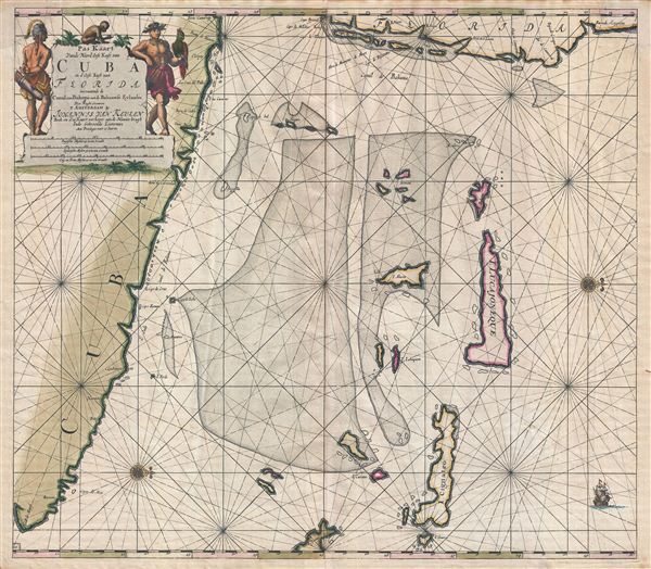
A fine old color example of Claes Jansz Vooght and Johannes Van Keulen's 1687 nautical chart or maritime map of the approaches to the Straits of Florida. Oriented to the west, this map covers from the eastern tip of Cuba to the Bahamas and from Florida to exuma, Bahamas. This is the first maritime chart to focus in such remarkable detail on the southeast coast of Florida. Portions of the Florida coast covered include the region from West Palm Beach to Miami and the northern Florida Keys. Several of the northern Florida Keys are named, including Key Biscayne (Cayo de Biscambos). Cape Canaveral is also noted (Cabo de Canaveral). A decorative title cartouche featuring New World Fauna and stylized American Indians appears in the upper left quadrant.
Cartographically Van Keulen derived this map from the 1675 map of Arent Roggeveen, Pascaerte Van 't Canael de Bahama as well as from Hessel Gerritsz's 1631 chart. The cartographic work of compiling this map is attributed in the title to Claes Jansz Vooght, a known partner in the Keulen firm.
<h6>Golden Age of Caribbean Piracy (c. 1650 - 1730)</h6>From a historical perspective, this map appeared at the height of the Golden Age of Caribbean Piracy (c. 1650 - 1730) and nowhere were pirates more likely to strike than in this narrow passage between Florida and the Bahamas. Dutch pirates operating with the support of the Dutch West India Company dominated the 17th century until the rise of English piracy in the 1690s. Roughly three years after this map was issued English (and many other) pirates began establishing themselves in the Bahamas, which were ideally situated to raid Spanish treasure galleons on <i>en route</i> from Havana to St. Augustine, their last stop in the New World before veering to open water for Europe. By early 1700s, Nassau had been declared a 'Pirate Republic' and more than 1,000 pirates had established themselves in the region. Despite its somewhat inaccurate presentation of the Bahamas, many pirates would have found this map useful, making it a true pirate's treasure.
Van Keulen issued this map in three states, of which this is the second. The first state appeared in 1684 and is identifiable for its lack of page number. Subsequent states appeared in 1687, which corresponds to the present example, and c. 1695. This map was published in both Van Keulen's Zee-Fakkel and his Zee-Atlas, which were published congruently to about 1702.
CartographerS
Johannes Van Keulen (1654 – 1715) was a Dutch cartographer active in Amsterdam during the late 17th century. Van Keulen was the son of Lucas van Keulen. Van Keulen's firm, ‘In de Gekroonde Lootsman' (In the Crowned Pilot), was founded in 1678 and registered with the Amsterdam bookseller's guild as 'Cross staff-maker and bookseller.' (The cross-staff is a nautical instrument used to determine latitude.) Two years later, in 1680, they obtained a patent from the States General of Holland and West Friesland to publish nautical charts and atlases. Together with his partner, the cartographer Claes Janz Vooght, Van Keulen published numerous atlases and nautical charts, including the Zee Atlas and Nieuwe Lichtende Zee-Fakkel. It was a massive five-volume atlas containing more than 130 nautical charts. The Zee-Fakkel established the Van Keulen firm as the pre-eminent maker of Dutch sea charts in the late 17th and early 18th century. In 1714, one year before Johannes Van Keulen's death, his son, Gerard van Keulen (1678 - 1726), took charge. Gerard continued to update and republish the Zee-Fakkel until his own death in 1726. The firm was later passed on to Gerard's son, Johannes II Van Keulen (1704 - 1755), who significantly updated the atlas, especially with regard to Asia, issuing the 1753 4th Volume, known as the 'Secret Atlas'. The final editions of the atlas were published by Gerard Hulst van Keulen (1733 - 1801), Joannes II's son. The final true Van Keulen edition of the Zee-Fakkel was published posthumously in 1803. It is noteworthy that though ostensibly controlled by the Van Keulen men, it was the Van Keulen widows who maintained and managed the firm in the periods following their husbands' deaths. After the death of Gerard Hulst Van Keulen's son, Johannes Hulst Van Keulen, ownership of the family plates and business fell into the hands of the Swart family, who continued to publish until the company closed its doors 1885, ending a cartographic legacy spanning nearly 207 years. More by this mapmaker...
Claes Jansz Vooght (1638 – 1696) was a Dutch astronomer, mathematician, teacher, surveyor and cartographer active in Amsterdam during the 17th century. Vooght described himself as a 'surveyor and teacher of mathematics and the art of navigation' and published extensively on these subjects. His is known to have been a surveyor for the Council of Holland and co-authored several books with Rembrantsz Dirck van Nierop. Though little is known of Vooght's life, his most important cartographic work appeared in conjunction with the prominent Johannes Van Keulen firm, with whom he partnered in 1680. Vooght was responsible for creating and compiling most of the maps in Van Keulen's seminal Nieuwe Lichtende Zee-Fakkel, with many early editions bearing only his name. Learn More...
Source
Keulen, J. van, De Nieuwe Groote Lichtende Zee-Fakkel, Part IV (Amsterdam) 1687. Also in: Keulen, J. van, Zee-Atlas (Amsterdam) 1687.
Condition
Very good. Repaired corner, upper left quadrant. Minor verso reinforcement on centerfold. Large rip from bottom margin extending about 13 inches, repaired with archival tissue. Some age toning. Like most examples of this map, there is some slight discoloration around the original centerfold due to variance between the acid level in the map itself vs. the acid content of the atlas tabs.
References
Burden, P., The Mapping of North America II, 590. Koeman, C., Atlantes Neerlandici. Bibliography of Terrestrial, Maritime and Celestial Atlases and Pilot Books, Published in the Netherlands up to 1880, vol IV,pp. 276-401. Phillips (Atlases) 530, 3444, 3453.